
BEFORE
I UNROLL THE LAST TALE of adventure which hound Day Twenty-Seven of this
first-ever Thruhike of Cebu, let me first acknowledge the people and the
establishments that had put their faith in me and my team. They are mentioned
from time to time in like articles and in Facebook. For the last time, they
will have their worthy participation in the completion of the Cebu Highlands
Trail and the ensuing Thruhike noted below:
DEREK’S CLASSIC BLADE EXCHANGE
TITAY’S LILOAN ROSQUILLOS & NATIVE DELICACIES
GV TOWER HOTEL PHILIPPINES
SILANGAN OUTDOOR EQUIPMENT
GALILEO SATELLITE CONTROL SYSTEMS-PHILIPPINES
BAKHAWAN BEACH HOME
GOV. HILARIO DAVIDE III & PROVINCE OF CEBU
SUGBU TURISMO (PROVINCIAL TOURISM OFFICE)
ADRENALINE ROMANCE BLOG
PARK N GO BAKESHOP
VIAJERO OUTDOOR CENTRE
LAVILLES FAMILY OF AUSTRALIA
FRONTGATE BURGER RESTOBAR
VERSA TWO-WAY RADIOS
APP OPS PHILIPPINES
HAM RADIO CEBU
CAMP RED BUSHCRAFT
& SURVIVAL GUILD
•
MR.
ALVIN JOHN OSMEÑA
•
MS.
JULIET MOLINA
•
MR.
NIÑO PAUL BERIALES
•
MR.
PERCIVAL ESPINA
•
PACING’S
HOUSE OF BARBECUE
•
VEN
GOING PLACES STORIES BLOG
•
MR.
MICHAEL SCHWARZ
•
MS.
WILMA RELLORA
•
MR.
RANDY SALAZAR
•
MR.
MARKUS IMMER
•
MR.
LESTER PADRIGA
•
MR.
ADOLFO OLMEDO
•
MR.
RONALD ABELLA
•
MS.
LOCEL NAVARRO
•
ATTY.
BRUCE RAGAS
•
MR.
JOAQUIN GOCHOCO
•
MR.
EMERSON BENOZA
•
MR.
GLEN DOMINGO
•
MR.
HAROLD BUTANAS
•
TACTICAL
SECURITY AGENCY
•
MR.
ALAN POOLE
•
SHOESTRING
XAYD BLOG
•
MS.
MIRASOL LEPON
MS. DIOCEL HINAY
•
QUIJANO
FAMILY
•
MR.
JEROME TIBON
•
MR.
ROMMEL MESIAS
•
MR.
JONATHAN BLANES
•
MR.
MELO SANCHEZ
•
MS.
AMAYA MONTECALVO
•
MR.
JEREMIAH DAYTO
•
DRINOX
KITCHEN
•
MR.
GLENN PESTAÑO
•
MR.
MATTHEW DE LEON
•
THE
KNIFEMAKER
•
SESEBLADES
•
MR.
MARC IVAN DE EGURROLA
•
ZUE
FASHION
•
MS.
LAILA MANTOS-ABADINGO
My
apologies for any omission that I might have made but let me take this occasion
to cite the following brave individuals who comprised my CHT Exploration Team,
namely: JONATHANIEL APURADO, JUSTIN APURADO, JOVAHN YBAÑEZ and late addition
FRITZ BUSTAMANTE; and my Base Support Crew in JHURDS NEO and CHAD BACOLOD. They
were all there on their own accord, offering their time, intellect, skills,
muscles and naked enthusiasm for a place under the sun.
This
citation also goes to another set of individuals who were in earlier explorations
with me on the first two segments of the CHT like ERNESTO SALOMON, CIRILO
TOLEDO, MARCO ALBEZA, CHARLTON BATHAN, ARCHIE MAYOL, RAYMUND PANGANIBAN, ELI
BRYN TAMBIGA, LEOMIL PINO, JAMES CABAJAR, JOHN SEVILLA, GLENN PESTAÑO, SILVERIO
CUEVA and ANTONIO VERGARA. They slogged and charged the unknown with me.
Finally,
I could not have done this without the faith and trust in the ALMIGHTY; the
support, love and understanding of my wife VILMA and my family. These are the
strengths and the inspirations why I persevered, against all odds, since I
started the exploration on February 20, 2011 from Lutopan, Toledo City; and the
first step of the Thruhike twenty-six days ago from Liloan Point, Santander.
Today,
February 14, 2017, is a special day, not that it is Valentine’s Day, but it is
the day that I will put closure of this historic Thruhike. The early morning is
still silent as I rose from the comforts of my Therm-a-Rest laid on the
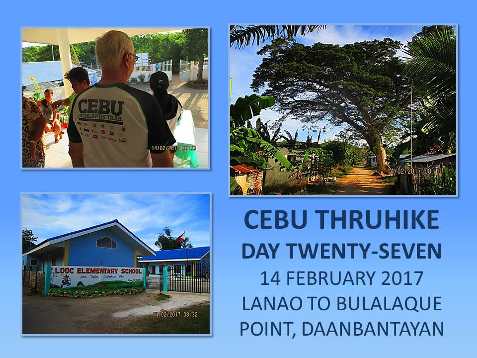
concrete floor of the multi-purpose building of the village of Lanao, Daanbantayan.
My morning habit for a glass of water led me to a water dispenser. The noise
woke up both Markus Immer and Jonathaniel Apurado.
The
sun had not thrust its will on this part of the world but I see five residents
starting to enter the iron gate that lead to us. They were carrying pots and I
believe there would be a feast later. We decide to clean up the place and put
all our equipment and gear into our backpacks as neatly as possible as was
practiced many times. We would not be needing our extra food anymore and we
decide to leave it with our hosts.
I
prepared the fossilized shell I picked up from Liloan Beach on the first
minutes of the first day of the Thruhike and placed it inside a small ziploc
plastic along with my business card and a paper indicating the origin of the
shell and the date of the Thruhike. Jon prepared his also and labeled a small
paper with his name and the date of the long walk. I drank coffee for the last
time on the CHT.

The
CHT itinerary says: 09:00 Arrival at Bulalaqui Point. Too stiff! It is
just a morning hike of a few kilometers but I can tweak it by walking at a
snail’s pace. We have a lot of time! Now the village hall is a beehive of
activity and the people of Lanao are preparing a breakfast in our honor. Food
are brown rice and bitter gourd with egg, organically grown along the lakeside
shores of the heretofore unknown Lake Lanao.
After
saying our deepmost thanks to the village council and the people of Lanao, we
faced the cold northeast monsoon wind outside and lurched forward at 07:45 to
fulfill our once-in-a-lifetime mission which no person or group have done
before. Markus is in high spirits, extending his adventures in his adopted
home. Connecting with the right people is his uncanny skill and he will not be denied
today.
We
follow an unpaved road that I have already identified as our route to Bulalaqui
Point. I have explored this route last November 2016 which capped the more than
five years long exploration of routes for the CHT. We entered the village of Tapilon,
Daanbantayan when we reached the Looc Elementary School. In the mildest of
weather, we barely shed sweat. We were not forcing our pace but walked in a
manner akin to touring with a bike.
From
a rough road, we were now walking on a new concrete pavement for just a few
paces only as an old trail that have served the residents in the past is now my
preferred path. It is a short cut to the highway which connect the town center
of Daanbantayan to the Port of Maya and vice versa. We reach a bridge and I guess
the stream below as the outlet of Lake Lanao. A concrete sign says we are now
entering the village of Maya.

A
motorcade celebrating National Heart Health Day overtook us as we walk
towards Maya. Some of the participants on the vehicles must have known our
presence and our business in their municipality and pointed their hands towards
us. They waved at us. The noise of the drums drowned out their shouting voices
as they were in the process of communicating with us. We waved back and became
part of their celebration while it lasted for a fleeting seconds.
We
arrived at the village hall of Maya and made a courtesy call to whoever is in
charge. A watchman welcomed and entertained us as we try to explain our
presence. A village council woman, Hon. Vanessa Laspinas, came and learned the
purpose of our Thruhike and she was glad upon learning that their village,
especially at Bulalaqui Point, is the terminus of our 27-day journey.
After
a customary picture, we bade goodbye and seek the route to Cebu’s own finis
de tierra, our land’s end of the north. I seek the small streets that would
lead us to the new Port of Maya. The wharf is still under construction but,
nevertheless, in operation. Two Ceres Liner buses parked at its empty parking
area waiting for a boat from Malapascua Island or from Palompon, Leyte. There
is a path that goes into a growing community and it had not changed despite
construction of more houses.
We
are now hiking uphill. It is grassy with patches of waist-high shrubs, some
coconut trees and a few huge trees. The trail goes into another hill which the
locals referred to as “pawikan gatakal”, because it looked like one turtle
riding on the back of another turtle. Whatever it is, I climbed over the great
hump and into wilder shrubs and better views of the yet-unfinished wharf and of
a beautiful cove on the other side.

There
is a cairn right on the trail and I stood above it and tried to propagate the
Versa Duo VHF radio in the direction of the repeater tower of Ham Radio Cebu,
140 kilometers or so away, just like I did in Day Three, Day Fourteen, Day
Fifteen and Day Twenty-two. At five watts power, the distance was just too
great even when I have the strong amihan to my back. The Versa served me
well and satisfies my experimentation.
There
are just a few meters of open space on the trail for soon we would be entering
a stunted forest cover. The trees would provide us shade and we would be partly
protected from the strong northeast monsoon winds, which is now more pronounced
due to our proximity to open sea. I have to tread the trail slowly because,
somewhere beyond my vision, would be the precipitous edges of Bulalaqui
Point.
At
exactly 11:07, we arrive at Cebu’s northernmost point. The adventure of the
Thruhike which had spun for 27 days plus two days rest halfway in Cebu City is
now at a close. The jagged rock that had separated from the headland many many
years ago danced among the waves a hundred feet below. My Canon IXUS camera,
its very existence bounded to document in still and moving images the CHT
Exploration and the Thruhike, is now more relevant than ever.

SPO4
Condino and PO1 Arreglado of Daanbantayan Police Station arrived to look over
our safety and witnessed our small celebration in this most uninhabited corner
of the great island province of Cebu. I am in the midst of the greatest
performance of my life, talking before my camera in video mode for a total of
211 seconds, acknowledging Providence, the people I am with and those who have
helped in the realization of the Thruhike and the CHT.
In
a location I previously marked months ago, I retrieved a “time capsule” which I
left last November 3, 2016. With that, I dug a shallow hole on the ground and
place it there, together with my fossilized shell and that of Jon’s as well. I
covered the hole back and placed a small cairn over it. I hope it would soon
become a landmark. A shrine for adventurers who would leave their marks
someday.
How
many would be placed there in the future? At that moment, I was clueless. The
idea of another Thruhike is a thing that I would not like to think of at that
moment. What I am thinking of right now is to go home and be with my wife and
my family. I missed them all especially my little grandson, Gifford. His
grandpops has a lot of tales for him. Another reason is the Brew Kettle beer
that I readied before Day Twelve. It would be very cold now. A good match for
my deprived body.

The
Thruhike had proven that Cebu can be walked along the middle, the interior, and
at its most rugged terrain from the southernmost beach to its northernmost
headland or vice versa. On both ends, you are assured of a dip in the sea by a
beach. Although there had been attempts to walk across its length, notably by
the party of Judge Meinrado Paredes in 1996-1997, it was not realized due to
the prevailing peace and order situation and scarcity of maps.
During
my explorations, the insurgency in Cebu have died a natural death but residues
of suspicions remained. For several times I was placed in many awkward
situations. People in the hinterlands are not used to seeing strangers walking
with big backpacks. It reminded them of the violent past. Although we talked in
the same dialect but there is no way I could explain to them of what is a
“hiker”, a “mountain climber” or a “mountaineer”. A few times, we settled on a
neutral word - “tourist”.
I
carefully planned my exploration hikes, making it sure that the local
government units, through Capitol, and the police are properly informed. It
does not give assurance though as what happened on separate occasions of April
and September 2016, where I or my team were escorted by the police and had to
terminate the activity. Once, we were threatened with harm in March 2012 and,
another time in January 2015 and October 2016, we were denied camp in a
village.
Maps
are important but I used it only during pre-route planning. Analog maps sold by
NAMRIA are utterly outdated by 20+ years. I used and studied online maps
provided by DOST Project Noah, before it was mothballed. I even screen printed
the mouse-enlarged maps on several bond papers which I brought in my
exploration hikes, just for reference only. Just like the analog maps, some
villages are off their true locations. Most of the time, I used traditional
navigation.
Anyway,
the Thruhike needs careful planning, enough logistics and a walk of AT LEAST a
month or more. (If people are intimidated of strangers casually walking, how
would they find you running?) Food is a consideration. You know, I have
developed a trauma of a certain breakfast food. You need to cook dinner and
breakfast with denatured alcohol. You need to use an alcohol burner. There is
no other way unless you hire a porter.
I
got cold sweat when I thought of doing another Thruhike with guests as I sat
inside the empty Ceres Liner. I am sure a lot of people would like to try the
CHT end to end. Unfortunately, I still have not possessed the data that the
radio tracking device provided by Galileo Satellite Control System-Philippines
and my memory would serve that purpose for the time being. However, I would
accept guideship jobs in segments only. The CHT is composed of eight segments.
It is much friendly that way and easy for me.
We
did it, finally. On that first few steps of that February 20 morning six years
ago, I never thought that I would reach the end of my quest. At that time, I
find it too ambitious and I was afraid that I might get sucked into obsession.
How did I overcome everything? Especially the logistics and the trickles of
support. I do not know. But one thing I know is you enjoy your passion and let
people believe what you do. You must be credible, honest, bold and human. And
you must pray.
Distance
Walked: 8.54 kilometers
Elevation
Gained: 35 meters and a low of 5 meters
Document
done in LibreOffice 5.2 Writer








