Showing posts with label Segment IV. Show all posts

Friday, January 7, 2022

2022-002 | ADRENALINE ADVENTURE HIKE: SEGMENT IV-B

TEAM ADRENALINE ROMANCE HAD walked through the first half of Segment IV and came out stuffed with better appreciation of the Cebu Highlands Trail. The challenges of the fresh sceneries that the “no man’s land” route provided have excited Team Adrenaline Romance so much so that they filed a leave of absence the soonest time possible.


When we breezed past Mount Manunggal on our way to Lawaan, Danao City the last time, they begun to enjoy the landscapes of their backtrail and picked off the familiar landmarks which had given their confidence a shaky ground to stand on. The second part of Segment IV – Segment IV-B – has different difficulties than the first and it offers another different side of Cebu. This is still a “no man’s land”. 

We choose the Cebu North Bus Terminal as our meeting place on October 13, 2018. Gian Carlo and Sheila Mei arrived first. Later, Apol came, and we found an empty bus bound for Danao City. The bus left Mandaue City at 05:30 and arrived at Danao at 06:45 and we found a small eatery to take breakfast. We also bought extra food for our lunch which our itinerary says 12:30 at Mount Mago. 

We left the busy city center at 07:30, each astride in tandem on a motorcycle-for-hire, bound for the village of Lawaan, our last place of engagement two weeks ago. We arrived there at 09:10 when the motorcycle I rode conked out and we waited for another. We hit the trail at 09:15. We were following a paved road that was quite shady and very peaceful. We faced a road junction and followed the one on the left.


The road rose in elevation and we were now exposed to the morning sun. As we walked over a ridge, we saw Mt. Kalabasa of Danao City; Garces Peak of Asturias; Mt. Matun-og, Mt. Mauyog and Mt. Manunggal, all in Balamban; and – surprise! – Mt. Babag, Cebu City. These were the great landmarks that we saw on our northerly quest that created furrows on our foreheads. As we checked our backtrails, these were now just drops of water in a pail. 

Walking on, we passed by a farmer harvesting pomelo from his fruit-laden trees and gave us two which Sheila Mei and Apol devoured without a trace and brought another with us. We walked on and we arrived on the trailhead in the village of Pili, Danao City. There is a trail that goes to Mt. Mago but I have to make a courtesy call first to a military detachment located nearby. 

After my business with the authorities, we pushed north at 10:20, following the trail that go over the ridges of this unnamed mountain range. The path is soft earth blazed by generations of feet while all around us are green meadows. It is rolling terrain without forest cover. On a rise, I read an elevation of 755 meters from my Casio Pro Trek.


We still brought a pair of Versa Quicktalk Go UHF/FRS transceivers which we used for our communications in Segment IV-A. While I took the point, Gian Carlo swept last and Apol and Sheila Mei in between. We used the radio to check each other out when visibility is hampered by rolling terrain or when a branch of a trail placed Gian Carlo in a bind. 

We arrived at the camping grounds of Mt. Mago at 12:40 and quite famished. We spent noonbreak here under the shade of one puny tree, enjoying lunch from food we bought earlier and finishing the one last pomelo for dessert. I noticed a pond. It had always been there the two times I was here. I excused myself and made a brief inspection. 

I found out that it is a seep that overflowed to a very tiny brook. I deduced that it became a small stream, ultimately dividing Carmen from Tuburan, until it became a river that flows out to the Camotes Sea. This unassuming pond could be the headwater of the Panalipan River! We took water from the pond and washed our plates, spoons and forks from twenty meters away dowhill.


We left Mt. Mago when dark clouds appeared with the clap of thunder and followed a trail in a forested area. The ground is dry and plenty of loose soil and pebbles. We came upon a very steep part which was kind of tricky. This path is so enchantingly silent that only locals know and, of course, me. Overnight campers would never go beyond Mt. Mago. We rested after that descent and rehydrated. 

From then on it would be rolling terrain once more, passing by solitary houses and farms and, sometimes, a family of cows blocking the way. The trail goes down to the remote village of Bangkito, Tuburan. We passed by a public school, going into their center where there was a basketball game in progress. Everyone stopped playing and looked at us. 

This was one of the critical areas during the insurgency problem in the ‘80s until the early years of the third millennia and everyone wanted to make sure that we were not armed. When they resumed their game, I released a sigh of relief. Then and there, I did a courtesy call to their village council while Team Adrenaline Romance stayed behind to fill water from a water reservoir.


On the way back, I brought a cold big bottle of Coke. We emptied it fast and we hoped we could produce another one later. We prepared our campsite and then our dinner. When the food was almost cooked, I went back to the community store to buy another cold big bottle of Coke. But it was the last they sold to me earlier. 

We had our dinner and pairing it with warm Coke was not bad after all. That night there was another basketball game and there were many onlookers from the different places. After the game there was a disco. The noise interfered in our quest to snatch that sleep. Motorcycles would park nearby and leave. Nevertheless, it did stop at 03:00 of the next day, October 14. 

We woke up collectively at 05:30 with eyes that hungered for more sleep. We prepared breakfast and, after eating, we broke camp. I went back to the village center to give the village council my appreciation of thanks in the form of a certificate, as I did yesterday with the villages of Pili and Lawaan. This was for their hospitality in accepting us in their localities and aiding me and my team during the exploration phase of the CHT and that epic Thruhike.


We left Bangkito and went east for that deep valley under the shadow of another mountain range found across us: Ngipon-sa-Ilaga. I almost missed a trail were it not for a girl who was observing us. After asking her directions, we followed the trail down the deep valley of Anahawan. It would twist and wind its way among the lower foothills of Mt. Mago. 

Cows and carabaos were tethered along trails and we have to make wide detours. When we reach a stream we rest for a while from the brunt of the morning sun. This was the same stream that I suspected to have originated from that small pond at Mt. Mago and this could be the upper portions of the Panalipan River. Downstream of me are small waterfalls and Team Adrenaline Romance had to change to Project BLUE t-shirts for a photo ops.     

After a generous rest of thirty minutes, we resumed our journey. The trails pass by meadows and farms and a very old oleander-leafed euphorbia (Local name: soro-soro). The biggest I have seen. This marked the start of the ascent to Taguini. The trail is well beaten and easy to follow.


We arrived at Taguini so early at 10:00 but it was empty of people and traders. I expected a market fair. I missed by a day! Anyway, we are two hours early for a noonbreak and we decide to have that at the village of Caurasan, Carmen instead. So we spent rest here and bought locally-baked bread and paired it with cold soda drinks. 

After twenty minutes, we resumed the last few kilometers of Segment IV-B. Team Adrenaline Romance, perhaps, assured that the last half of the CHT was about to end, walked with a confident and springy stride this time. We reached Caurasan at 12:30 and checked in at their village center with our identification cards with a civilian interloper who insisted on voter’s ID! 

After that, I did another courtesy call on a military detachment nearby and then we ate lunch there. We left Caurasan for the town market of Carmen astride motorcycles-for-hire. The ride down to town was a long one and we arrived at 14:00, time good enough to take it easy for our return to Cebu City. Team Adrenaline Romance celebrated their feat with an early dinner in a Japanese restaurant inside SM City.

Team Adrenaline Romance had achieved one-half of the CHT by finishing Segment IV-B, which was 17.68 kilometers in length. With that, they extended their mileage total to 207.73 kilometers which was quite impressive! They had adapted to the rigors of what it was like when walking a long trail like the CHT which is partly wild, very humid, unimaginable difficulty in terrain and somewhat dangerous!  

The lands we passed by in all of Segment IV, to include parts of Segments I, II and III, were indeed very dangerous if we walked it in another time, say 1987 or 1995. That is the reason why adventure tourism and outdoors leisure activities did not grew beyond the known safe havens. Many have tried to open these corridors among Cebu’s mountains but it never prospered. 

The exploration of the CHT and its opening to the public as a guided adventure hiking tour came at a favorable time when such threats and troubles to foot travel have disappeared although residues of it remained which comes in the form of suspicion and distrust. By and by, people will come to terms with their past and embrace change which is harmless, fun and productive.  

Gian Carlo and Sheila Mei wrote about their Segment IV-B experience on the Adrenaline Romance Blog under two installments: 

Cebu Highlands Trail Segment IV-B: Lawaan, Danao to Bangkito, Tuburan.

Cebu Highlands Trail Segment IV-B: Bangkito, Tuburan to Caurasan, Carmen.


Sunday, November 21, 2021

2021-045 | ADRENALINE ADVENTURE HIKE: SEGMENT IV-A

SEGMENT IV OF THE CEBU Highlands Trail is the beginning of where leisure mountain camping ends. The latter had been popular, especially at its two prominent peaks: Mt. Manunggal and Mt. Mauyog. These had been shaped by constant activities of outdoor clubs beginning in the ‘80s. What lies beyond is terra incognita or “no man’s land”. 

I decided to break that impasse by boldly walking through those areas in October 2015 with which places have confined the activities and stunted the growth of the collective outdoor community only on those two peaks because it was risky to do so. That exploration opened a corridor of passage where I eventually used during my Thruhike in January to February 2017.

Segment IV is divided into two sub-segments because of its length: Segment IV-A starts from Mt. Manunggal, Balamban and ends in Lawaan, Danao City. Segment IV-B takes off from Lawaan and finishes at Caurasan, Carmen. These were the very places which were frequented by armed groups in the ‘80s up to the earliest years of the third millennium. 

But Gian Carlo and Sheila Mei of Team Adrenaline Romance were ready. They understood that mindset which only long trails could provide. They honed this, starting from Mt. Manunggal to Mantalongon, Dalaguete, churning a mileage of 166.56 kilometers on four sets of weekends for Segment I, II and III. It was beyond my expectations considering that segment hiking the CHT was still an experiment yet. 

Experiment, in the sense, that I could not choose the people who desires to walk the CHT’s rugged length, the tyranny of the humid tropical climate, the remoteness from help and the very inquisitive locals. There was one major adjustment that I had made in the light of these and this was the deliberate reduction of pace. I cannot afford accidents in the middle of nowhere. I had to have a modicum of control on people’s movements, especially at places where you cannot observe them. Then, of course, there is the radio.

So the paths to the north of Mt. Manunggal were ripe for the taking on that day of September 29, 2018 and Team Adrenaline Romance were in the right place, at the right time, with the right person leading them to places where only a handful had been. Going with them were Apol and Swiss adventurer, Markus. This was the very first time that adventure tourism would be exposed on these misunderstood places. 

After a meet-up at the Ayala Mall van-for-hire terminal at 05:00, we cruised over the Transcentral Highway in a passenger van and to our preferred starting point, on a lonely corner where a feeder road led to Mt. Manunggal. On this very spot, Team Adrenaline Romance launched their campaign of the CHT seven months ago, which was the first half of Segment I. It was an extraordinary feeling for everyone who were here. 

We transferred by motorcycles-for-hire to the campgrounds of Mt. Manunggal and proceed to acquire something to eat for we simply forgot to eat breakfast, except for Markus. Then the journey for Segment IV lurched under a controlled pace at 07:15. The weather was mild but, once out of the mantle of fogs, it would be humid out there. We followed the route I explored in 2015 and it remained wild.


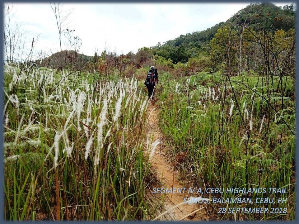
The forest had reclaimed what was theirs after a road was created in their midst. On a trail in between tall grasses, I spotted a large bird scat. It was made by a mature grass owl, perhaps a pregnant female. This was her breeding ground. Trees abound on both sides, 20 meters away and, ahead, were wild raspberries (Local: sampinit) which branches were heavy with succulent fruits. 

The path narrowed as we passed through it, plucking as many raspberries as we could and enjoying the freedom of the hills. We delighted the solitude of the moment, for we know, in five years’ time, people would come to settle and claim farm patches here. That would be alright if you are a subsistence farmer but what I feared really are outsiders who would buy rights to big chunks of land and then fence off both humans and beasts away in the name of “development”. 

I saw a couple of homesteads along the way but I know also that the lure of money from these outsiders would make them exchange their way of life for the lowlands, forfeiting their children’s rights to the land and its bounties. It is a cycle as moneyed lowlanders from the cities purchase properties to do “farming” while the true farmers on the mountains sold those rights to make a living in the urban areas. Then they exchange places, maybe in a hundred years. 

After snaking our way through that beautiful forest, we were met by wide open spaces – Cebu’s “Big Sky” – where you could see beyond the highlands rolling north before you without any obstacle. We stopped here for a while to rest and rehydrate. Markus carried with him binoculars and I saw better with a larga vista than with my own naked eyes.

With magnified vision, I noted Garces Peak of Asturias, Mt. Kalabasa and Mt. Mago of Danao, Ngipon sa Ilaga of Carmen and Mt. Kapayas of Catmon. Beyond was a blur of blue. All of these are on the fringes of Segment IV. These might be very far from where we stood but, in a matter of a day, we would be below Mt. Kalabasa. Another 2-and-a-half days, Mt. Kapayas. Team Adrenaline Romance have used my assessments to gauge their strength, stamina and rest time since day one of their journey. 

If Markus had brought a binocular, he would be bringing other items as well. While a binocular is a valued item, it is not a necessity on this long trail. He has a backpack with him and another big sling bag made of canvass. He answered to my appeal in bringing a gift for the grandchildren of Candelario Garces, who lived on a very remote mountain of Kaluwangan, Asturias. It was a board game and I decided to remove the burden from him and carry it myself.

We all carried extra loads for the Garces grandchildren. We would unload that tomorrow and we need to reach Cabasiangan first for the day was getting warmer. Tech1 Corporation, distributor of VERSA 2-Way Radios, loaned me a pair of their VERSA QuickTalk Go, for field tests. It is in FRS/UHF band which is ideal for urban areas with transmission distances of up to 200 meters but equally effective where there were no obstacles like unpaved mountain roads. I let Gian Carlo carry one of the pair. 

This heavily-furrowed road brought us to a small community which has a small store that sells cold soda drinks. They did not have something cold, this time, since a ref conked out. What the place had was a wounded, leopard cat (maral). It was breathing heavily half-alive and I cannot understand why people here did not put it out of its misery. Pity aside, it was my first time to see it so close, although I saw glimpses of this many times on the mountains. 

Leaving that poor animal, we decided to move on. We took a short cut but the imperious sun was still bearing its heat to our exposed skin no matter how we tried to be smart. As I was with Apol, a hundred meters away from the village center of Cabasiangan and waiting for them, my VERSA QuickTalk Go caught a transmission from Gian Carlo. I left my bag with Apol and proceed to their location. 

It was very warm at 11:15 yet I overtook a male local and appealed to him to carry a bag of one companion who may have been bogged down by the severe warmth. After a few minutes, Gian Carlo, Sheila Mei and Markus emerged with the local carrying a backpack. We thanked the local and paid him for his valuable services and we all decided to enjoy our noonbreak under the shade of a covered basketball court. 

At 13:30, we left Cabasiangan but not after ensuring that Markus gets a motorcycle ride down the lowlands and safety. The tropical heat was just too much for him. When we continued our journey, it was really warm. No amount of breeze could stymie the heat. We rest when we find a shady spot where there were no houses. We city people have habits, ways of talking and body language which locals might find unusual and might gave off a different connotation if espied.


We arrived at the village center of Ginatilan and, fortunately for us, their village chairwoman was present and I personally asked her approval to let us stay for the night at their old village square found at the bottom of this mountain where it meets the Lusaran River. It was downhill walk but, at least, it hid us from the overpowering heat of the mid-afternoon. At 16:00, we arrived there and claimed their granary as our billet area. 

On the second day, September 30, we left Ginatilan to cross the Lusaran River at 07:45. The water was just right as against the last time where it was thigh level. Everyone crossed the stream safely to the other side, which became the Municipality of Asturias. On the higher bank was a community square and a public school. 

Seen a familiar face. It was the farmer whom I talked to during my 2017 Thruhike. He was the son of a Korean War veteran and currently employed as a sentry in the said school. I gave him my extra Swiss Army Knife as my token of friendship and as my gesture to establish rapport in this place, as I did so on other places.  

Of course I printed certificates of appreciation for those villages which welcomed me during the CHT route explorations and the Thruhike. In Segment I, it was the village of Buot, Cebu City. In Segment II: Tubod, San Fernando. In Segment III: Mantalongon, Barili; Mompeller and Balaas, Argao; and Mantalongon, Dalaguete. Here, in Segment IV-A, I already gave Ginatilan. 

Soon, I would provide a different appreciation of thanks to Candelario Garces and his wife for welcoming me during the October 2014 exploration and for sharing what little food they had during the Thruhike where I passed by here last February 2, 2017. We have gifts for the Garces couple and their grandchildren. Yes, we have extra cargo but it would be worth its weight in bringing it here. 

I followed the trail up a ridge. It was another very warm day but I have one person less to look after this time. The view from up here was superb and you could see the serpentine path of the Lusaran River below, shining as the sun reflected its surface. I struggled with my breathing under the naked sun until I reached a forest line and stopped to rest, leaning my weight on a live tree. The canvass sling bag with its cargo were both heavy. 

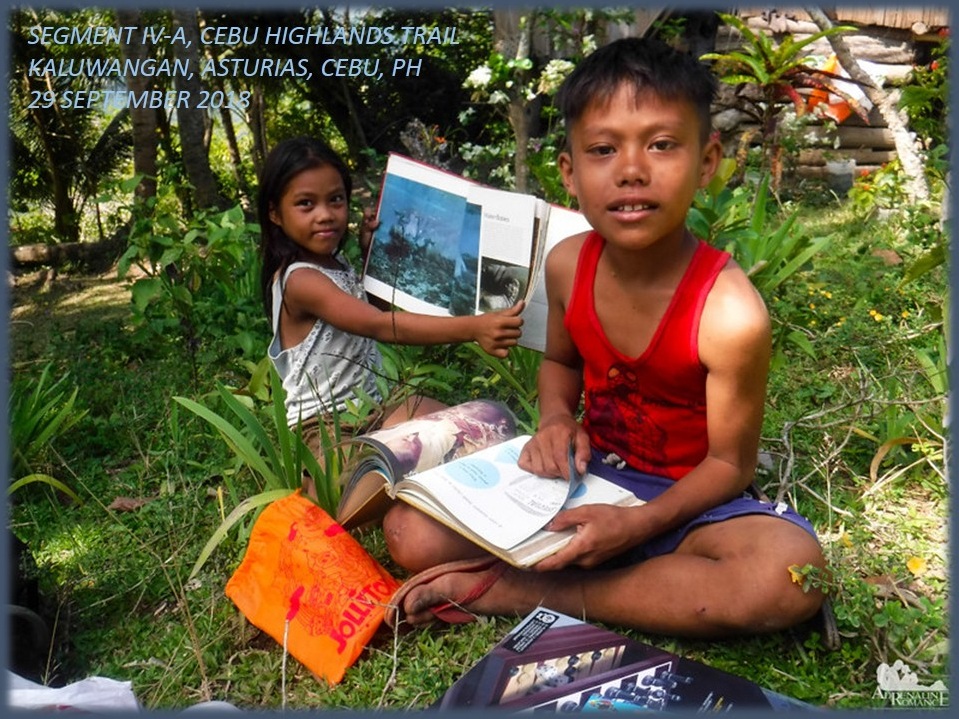
After a few minutes of catching my breath, the covered trail led to a high meadow where there were two children playing. Instantly, the kids recognized me and respectfully took my hand to kiss it. The kids, a boy and a girl, were very happy and laughing to see visitors. They led us to their remote home. We finally arrived at the Garces Homestead at 09:40 and unloaded our gifts.

There was the expensive boardgame bought by Markus which I carried on his behalf. Gian Carlo and Sheila Mei unpacked their bags to produce two loaves of sliced bread, chocolates and more food. Apol has notebooks, pencils, ballpens, crayons and writing pads. On my part, I brought two books, four paracord bracelet assembly kits and free giveaways from a popular fastfood chain.

Apol was most helpful with her experience in dealing with children, orphans and youths in conflict with the law. She made the children overcome their shyness and sang and played with her. She even taught them how to create a paracord bracelet from the assembly kits. We gave all the food we brought to the beaming grandparents.

After an hour of rest and interaction with the two children, we bade goodbye and proceed on our journey to finish this sub segment. We were feeling blessed to impart something which would be appreciated very well by them as well as to their grandparents. It was a nice feeling and the hour-long rest was well deserved for the four of us. 

So I followed the rest of the trail through the graces of a kind memory. Sometimes I missed a path but most of the time I was correct. If I was in doubt, I brought out my compass for the cardinal directions. If it could not help me, I consult my map but it rarely came to that. Navigating in an almost unfamiliar terrain by memory sometimes burn you out.

When I missed a trail, I retraced my path until I found a familiar something. It could be a landmark, a familiar smell or just a gut feeling. But a chance meeting with a local is most valued. So I found the true path on the premise of the familiar and I found the unnamed river that separates Asturias from Danao City. It is a long descent and somewhere up ahead would be the pot of gold. 

We reached the bottom and prepared our lunch at a time. We are behind schedule. It was already 13:00. While Gian Carlo was at it, Apol and Sheila Mei took a dip on a deep pool of a stream where there was a small waterfall. God, it was so warm. I keep Gian Carlo company and exchanged stories to keep us occupied on dry ground. It was a good moment under the shade, recouping strength with coffee even on a very warm day! 

After a more than an hour of noonbreak, we crossed the stream and were now in Danao City. A path led to a large tree where there was a bull blocking the way. Although it was leashed, it could still reach us should we took any of the safest spaces to walk. The best thing to do is walk as one tight group so as to intimidate or confuse him. Small fries do that to keep at bay bigger fishes. 

There was a community and we moved through it and over a steep hillside which was bare and loose. Then we crossed a smaller stream and we were now in the village of Sacsac. We reached a paved road and stopped at a store to hydrate with cold RC Cola, just like I did during my thruhike here. For a good 15 minutes we took our rest ignoring a huge but empty jeepney calling out for passengers. We disregarded the opportunity, afraid that it may stay longer and ruin our itinerary. 

By 15:20, we moved out, following the ascending road that offered a view of the imposing karst formation and forest that was visible from yesterday’s walk. At the steepest part of the road, the empty jeepney roared ahead of us on its way to the Danao City terminal. Pride kept us grounded afraid to cheat for just a while. Anyway, after an hour of walking up several rises which seemed to have no end, we arrived the main road at Lawaan. 

We made it at 16:45 but, at this hour, in these places, transportation were scarce. After a longer wait, we were able to convince two motorcycle-for-hire drivers to ferry us down to the city center. Although downhill, the distance was great and we arrived 30 minutes later. We transferred to midget public jeepneys, dropping by at Liloan, to grace the opening of a friend’s halo-halo franchise and ingratiate ourselves with the specialty of the house to recover lost energies.

Team Adrenaline Romance, after Segment IV-A, have amassed a total of 190.05 kilometers and there is the Segment IV-B that is scheduled for October 13-14, 2018, which would surely goad them over the 200-kilometer mark and complete the first half of the CHT. That was a tough walk and the trail north has lots of these. But Team Adrenaline Romance is now in the groove of things of how the CHT ought to be walked…and enjoyed.  

Gian Carlo and Sheila Mei wrote about their Segment IV-A experience on the Adrenaline Romance Blog under two installments: 

Cebu Highlands Trail Segment IV-A: Mt. Manunggal to Ginatilan, Balamban.

Cebu Highlands Trail Segment IV-A: Ginatilan to Lawaan, Danao.