Wednesday, May 24, 2017
THE THRUHIKE JOURNAL: Day 6 (Mantalongon to Balaas)
IT
IS A COLD DAY AND IT IS DECIDED that Jingaling Campomanes, Mark
Lepon, Christian Tan and Glyn Formentera would not walk with us
today, January 22, 2017. They were planning to separate from us once
we reach the foot of Mount Kandung-aw but plans changed as easily as
water shifts its current. The artificial mood of yesterday left.
Back to reality, of walking the Thruhike with only Jonathaniel
Apurado as companion. We do not speak often because I walk far ahead
of him. We only converse during rests and with locals. The Thruhike
is not a jolly activity, it is solitude.
The
Thruhike then is a pilgrimage of silence, imposed on you by no one
else, except, by you. Seriously, the Thruhike is thought to be an
amazing journey of the self through places where your soul would want
itself to be – in the serenity of the hills. I can not yet
decipher the intrinsic value of the Thruhike for I am yet at Day Six
and the hardest parts are yet to come, although five days of hiking
are daunting enough. I will soon arrive at places where either my
will, my patience or my determination will be stretched thin or
pressed hard. I have experienced these often during the early
explorations of the Cebu Highlands Trail and I was fortunate it had a
short time frame of three to five days. But this is different. This
is 27 days!
After
saying my appreciation and thanks to the officials of Mantalongon,
Dalaguete, we set off at 08:30. The weather is almost Baguio
weather, cool and very mild. A thick cloud dropped a wispy shower
that vanished instantly as it began. Sunday is a day of rest for
most of Cebu and the rest of the world. For most people visiting the
outdoors, it is a trip to peaks, beaches or waterfalls. For most
destinations, people are expected, whether on official routes or on
“backdoors”. In a Thruhike, or for that matter, explorations,
you are viewed with suspicion since you are not supposed to be there
or there are no precedents of people turning their places into
tourist destinations.
Sunday
is then a day which I considered very much with importance in my
itinerary. This is the Thruhike’s first and I designed it that we
walk today for Balaas, Argao. Whether we arrive early or late, it
does not matter, for people there are already familiar with us. We
spent a night there last February 20, 2015 after a lengthy
explanation. We were then in the middle of the Segment III
Exploration Hike and the late afternoon brought us to there. It
ended well and, today, it would not be difficult to obtain their
goodwill again.
There
is no other way to walk the “Vegetable Highway” except on
pavements. As of today, I cannot see a good reason yet to find a
trail to Argao. I see many and they criss-cross deep valleys and
climb over hillsides, which might be romantic but impractical due to
its difficulty. Whoever designed this road was a genius and this
road was not made when things were started to be ran by people
“running the country like hell”. It was designed and constructed
by someone who belonged to a country that was supposed to “run this
country like heaven”, if you quote a dead president’s statements
which does not make sense.
However,
I see such two options in a future shift of paths. The first would
enter Argao through the Cambantug Mountain Range, cross the Salug
River over to Cansuje, Argao and go north to Alumbijud, Argao. The
other would be that you would have to go to the side of Badian from
Osmeña Peak, follow a route over the mountain ridges that connect
with that of Argao which are dotted with coal mines and pockets of
lawless enclaves. If I could have started the explorations 10 or 20
years ago, I would have not been wandering on roads but on trails.
The fact that I started this epiphany in 2011 and finished it only in
2016, is a testament of that shortcoming plus, another fact, that I
have no big corporate backing or a team of corporate personalities.
You
would have to appreciate of what I did in completing my explorations
of finding a route for the CHT, which no one had ever done before on
the island province of Cebu, without support, except from a few
notable individuals like Alvin John Osmeña, Aljew Frasco and Jose
Mari Gochangco, who believed in what I was doing. And you would also
have to appreciate me even more of my boldness to go on a Thruhike of
a CHT that was not even made and documented with the benefit of a
global positioning satellite system but on the premise of memory
borne out of the quirks of traditional navigation.
Anyway,
this memory brought me to the sixth day in such progress and
precision as good as using a GPS. The week-long rain that happened
before I started the Thruhike had left its mark on the appearance of
this road. Just repaved with solid concrete, rockfalls from above
and landslides undermining below threaten people who use this. It is
simply dangerous to use this road for the moment. We are forced to
walk on the outer edges, a safe distance from a rock fall, of even a
size of a thumbnail, could be life threatening if it falls directly
on the head.
Hazardous
that might be but one village seems to live with that. On the road
to Ablayan, Dalaguete are many small banners placed on both sides of
the road, aside from three bigger ones strung across, declaring a
fiesta celebration. People were in a festive mood and screams of
pigs were heard everywhere up a hill or down a gully. The road wove
on more hazards but not that many anymore yet this is one scenic
stretch highlighting the valleys around Mantalongon as the
“Breadbasket of Cebu”. We arrive at Maloray, Dalaguete at 10:30
and you will see many little rice terraces planted with an upland
variety.
Mount
Kandung-aw towered over us but we had been there in February 2015 and
is now included as one of the interesting features of the CHT. The
peak is a good alternative to spend a weekend in these parts and
would relieve the pressure off the very popular Mount Osmeña from
local tourists. We walk on and we see a lot of people waiting for
porters to carry their goods over the other side of the road since a
big part of the road was swept away by the rains of early January.
Likewise, farm produce were dumped here coming over from the other
side where it is loaded onto trucks while motorcycles waited on both
sides. Ah, commerce.
We
crossed the chasm nimbly as locals do while a few motorcycles braved
the slippery and steep stretch. Since we covered so much ground in
the morning, I deem it necessary to take our noonbreak as early as
10:55 since the mild climate changed into warmth. I munch on two
pieces Titay’s Liloan Rosquillos, six pieces of Park N Go Bakeshop
bread, a Nutribar and my jumble of trail food. With water I popped
in a Herbalife Natural Raw Guarana capsule into my mouth and watch
three locals walk past me with big baskets at their backs, carrying
70-80 kilos of vegetable pears, cauliflowers and carrots supported
with tumplines to their head. This road made their lives bearable.
At
12:00, we proceed up the road. We saw another road joining the ones
we are following. The junction got washed and a temporary patchwork
of rocks and concrete were arranged to hold the earth above it but
got washed again. It looks scary and that is why I saw no trucks
parked on this side from the chasm we crossed. This road goes up to
Badian while our direction goes to Argao. We stop by a new parish
somewhere in Manlapay, Dalaguete where parishioners in their Sunday’s
best just came out from a church service. The rest took longer,
since there is a shady spot and a cold Sparkle to beat the heat as
Jon enjoyed talking with the locals.
The
journey continues into the heart of Manlapay, the last village of
Dalaguete, and then into Argao. At a road corner going to Balaas,
Argao, I immediately dispatch a text message to the Argao Police
Station so they will be informed of our presence and our activity. We
arrive at Balaas at 13:40 where the honorable barangay chairman,
Ricardo Gonzaga, and the village council welcomed us. They expected
us at 16:00 since that was the one indicated on our itinerary but we
somewhat have developed wings on our heels. Or is it that I just
made this day’s schedule conservatively kind?
Why
are we expected along the way? Well I found it out the hard way
early in my exploration hikes, especially at San Fernando during
Segment II which was done last March 2012. Since then, I made it
necessary to make my activities known by sending out letters to
Capitol and to the Cebu Police Provincial Office but, sometimes, it
does not give assurance like what happened during the last day of
Segment VII last August 2016 in Daanbantayan. To make my Thruhike
seamless, I made a courtesy call on the Honorable Governor Hilario P.
Davide III last November 25, 2016 and the rest is history.
Under
the protective shelter of the barangay hall, we claimed our billet
area. We released all the stress of the day and just enjoyed the
stillness of rest. Across us is the view of the wide Salug River
Valley, the Cambantug Mountain Range and Mount Lantoy. We are
treated as guests and a plastic tray with cold Sparkles and bread
came our way courtesy of Hon. Gonzaga and the people of Barangay
Balaas. We arrived early and the early rest benefited our feet. We
are now in the middle of the southern leg and we made good progress.
Tomorrow would be different. We would be expected at Sibonga and it
would be a long day.
Distance
Walked: 13.47 kilometers
Elevation
Gained: 793 meters and a low of 502 meters
Document
done in LibreOffice 5.2 Writer
Posted by
PinoyApache
at
09:00
0
comments
Labels: Argao, Cebu, Cebu Highlands Trail, Dalaguete, journal, thruhike
Wednesday, May 17, 2017
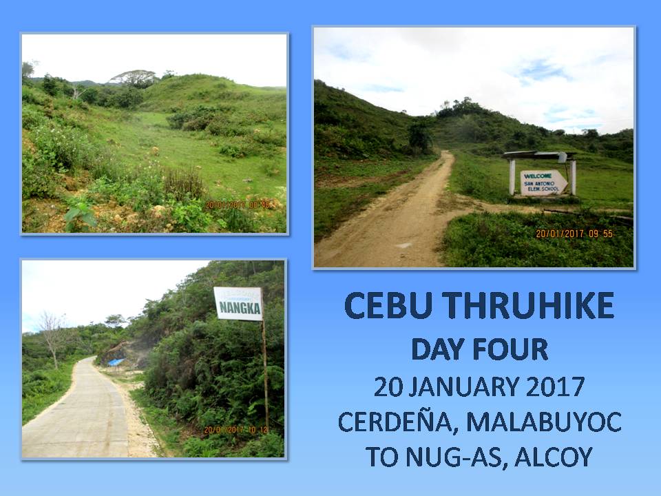
THE THRUHIKE JOURNAL: Days 4 and 5 (Cerdeña to Mantalongon)
DAY
FOUR ::::: IT IS GOOD TO SEE SUNRISE after three days of moody early
mornings. It rained the whole night but it was not that cold. The
forest protected us from the elements. Although there was light rain
today, it is so-so and is not bound to stay for long. I touched my
wet clothes that I hanged under the canopy sheet. Partly-moist but
wearable just the same. The Lorpen socks are now better than the
time I removed it yesterday. This would be its last day of use and
would probably be worn again on the northern leg of the Thruhike.
Today is January 20, 2017.
It
is 06:00 and I decide to tour the campsite for a good place to call
in nature. When I returned, Jonathaniel Apurado is holding a pot
that hot water is ready for coffee. Same breakfast fare of Knorr
soup and rice as was done in past mornings. We break camp at 08:12
and it is a very very mild day. We would be walking on roads where,
before, were trails. I may be a romantic but I am also a realist.
Gone are the days when life was difficult for mountain residents.
The presence of roads are a blessing for them, removing them from
isolation, having access now to the economy of the lowlands, wide
opportunity for education and better income which they could not
wrestle in the past.
Despite
the roads, the scenic views have not changed. The deep valleys on
both sides are filled with seas of clouds after a rain. There are
such few places in Cebu where you could view, while walking, both the
western coastline, which includes Tañon Strait and Negros Island,
and the eastern coastline, where you can see past Bohol Strait, Bohol
Island and Siquijor Island. The route follows a narrow range of
mountains, skirting two opposing big river systems, that connect the
Southern Cebu Mountain Range, that start from Barili to Alcoy, to
another mountain range in Oslob which is dominated by Mount Bandera.
A
lone Brahminy kite flew over me and it circled overhead riding the
thermals as I was about to make my way down to where this new road
would join the road at Upper Beceril, Boljoon. We turned left and
rest instead at San Antonio, Boljoon, at 09:25 near where we could
replenish our water bottles. This is the road that goes to Nangka,
Boljoon and this is the road where so much verdant hills are seen at
closer distance on both sides, separated by narrow strips of farms.
It is unpaved for the most part. Another scenic stretch which goes
all the way to Nug-as, Alcoy.
We
arrive at Nug-as at 11:35, hours ahead of schedule. We cannot just
proceed to the next destination, which is in Mantalongon, Dalaguete,
even if we are capable of doing it today. We cannot just alter the
order of things this time just because I have the upper hand. There
are times where you would have to honor what is on the itinerary and,
for that matter, we would have to stay at Nug-as for the rest of the
day. I have guests who would arrive later and we also have to meet
our supply team tomorrow afternoon at Mantalongon. Good sense
dictates that we would have to follow the itinerary to the letter.
The
early arrival would do well instead for our bodies so it could
recover from the hike of four straight days. This is another phase
of the Thruhike where you would have to balance things out since the
body could not bear the punishment for long. Remember, we still have
23 days more of walking. I do not want ourselves getting burned out
halfway to the end or giving up somewhere along the way to injuries.
Besides, I have a couple of sore toes to look over and a pair of
shoes to dry. Considering all these, I sent a message to the Alcoy
Police Station informing them of our presence.
We
proceed to the barangay hall and asked permission to stay. It was
not difficult to obtain since the one assigned today was someone who
knew us from last time. We tied our hammocks on the same places
where we fixed it last time. We do not have to use the sheets since
there is a roof. We eat for the very first time a hot noontime meal
of local noodles, the extra I carried just in case. I rehydrate a
lot of liquid from powdered juice and Extra Joss and tuned in to an
FM station signal coming from Negros Oriental. It was a very
relaxing afternoon just lying down on a bamboo cot which the body
really needs.
I
would have stayed on the cot long but I have to find a cellular phone
signal. We do not know if the GPS tracking device provided by
Galileo Satellite Control System Philippines is transmitting our
geolocations to them. The problem is that the only place where I
could catch cellular signals here is on a waiting shed located 250
meters away. Photos and information from Day One to Day Four would
be sent by my Lenovo A7000 smart phone and have to be posted in my
Facebook wall to update my wife and family, my friends, my sponsors
and my followers. It was slow at times when the signal appeared on a
single bar and disappears from time to time. For text messages, I
relied on my Cherry Mobile U2.
At
17:00, a police car from the Alcoy Police Station, led by PO1
Regidor, arrived to see how we are doing. They were sent to assist
us if ever we encountered difficulty in finding our way in their
area, which did not happen anyway. They stayed until 19:30. When we
were on our own, we commenced our dinner of Korean spicy noodles with
a sprinkling of shredded dried squid, sweet potato leaves and
dehydrated seaweeds. We were well rested and waited for our friends
to come but somehow they got delayed. We slept instead when the
clock hits 22:00.
Distance
Walked: 11.55 kilometers
Elevation
Gained: 839 meters and a low of 359 meters
DAY
FIVE ::::: JONATHANIEL APURADO WOKE ME UP at 05:00 that our guests
have arrived some three hours ago. I am sure they would be tired so
I let them rest for a couple of hours more. They have set up
shelters in a car porch just a few meters away from the building
where we are housed. They are Jingaling Campomanes, Mark Lepon,
Christian Tan and Glyn Formentera and all belonged to the Camp Red
Bushcraft and Survival Guild. Their presence and participation are
more of supporting the Thruhike. They would engage in a dayhike with
us today – January 21, 2017, from Nug-as, Alcoy to Mantalongon,
Dalaguete.
Jon
had taken over the cooking and there is Knorr soup and rice, boiled
quail eggs and coffee. After breakfast, we took down our hammocks
and stuffed all our things inside our backpacks. I changed into a new pair of undershorts and a clean pair of Kailas socks. The Jack
Wolfskin shoes are now dry as well as my “uniform”. We are now
ready to start Day Five except that our guests were still asleep. We
shook them awake at 08:00.
We
all leave Nug-as at 09:25 and this was the most late that the
Thruhike had started. I have an additional cargo, ten small bottles
of Yakult Cultured Milk, courtesy of Jingaling, which I carried
inside a plastic bag with either hand. The sun finally appeared but
not that scorching. January and February are the best time to engage
in a Thruhike here in Cebu. You will be facing the cold winds that
the northeast monsoon would bring in from the icy winters of Japan,
Siberia and China. The sun would slightly be at your back since
winter solstice changes the angle of its shadow.
We
cross the boundary into the Municipality of Dalaguete and the village of Catolohan at 10:45. A lone Brahminy kite
appeared in the sky, this time, much nearer. We arrive at Nalhub,
Dalaguete at 12:10 and stopped for our noonbreak. Jon and I subsist
on our food supply while the rest make use of theirs. Cold bottles
of Sparkles cured those parched throats. Afterward, I shoot a text
message to the Dalaguete Police Station and informed them of our
activity, providing them our names. This is now a necessity since
our party becomes bigger and noisier and it might send wrong signals
to locals.
After
an hour, we proceed on our hike and passed by Langkas, Dalaguete at
14:00. The hills here becomes like those seen around Osmeña Peak
which is good as scenic attractions. The road goes up and up but I
kept on going without stopping. I have taken my regular doses of one
Enervon Multivitamin capsule and two Herbalife Natural Raw Guarana
capsules each day and these might be the reasons I packed so much
power today? Perhaps, but it is too early to tell. The long rest of
yesterday might have to do with it.
Anyway,
I arrived first at the Mantalongon Vegetable Market at 15:00. I
expect to be here at 16:00, enough time to receive my supply team who
will arrive at 17:00. As soon as everyone were all accounted for, we
walk to the short distance to the barangay hall of Mantalongon. We
are expected today by their officials and we were provide the free
use of a building with toilet and running water. Just a few minutes
after us, the Toyota pickup of the supply team arrived very early.
Driving is Markus Immer from Switzerland with passengers Ernie
Salomon, Justin Apurado and Glenn Pestaño with son.
They
are also with the Camp Red Bushcraft and Survival Guild and how glad
I am of seeing all of them, giving their support wholeheartedly of
the Thruhike as volunteers. I could not ask for more. The supply
team had brought bread from Park N Go Bakeshop, courtesy of Randy
Salazar, aside from our daily fare of food and fuel for the alcohol
burners. Markus also brought two boxes of small brownie cakes baked
by his wife Analyn as his personal contribution. I shared what we
have with the barangay officials of Mantalongon.
We
left for a while the barangay hall and proceed to the market to eat
early dinner at 16:00. We found one local restaurant big enough to
accommodate all eleven of us. It was the first time in the Thruhike
that Jonathaniel and I eat food that was not our cooking. Glad that
the itinerary brought us to Mantalongon and break that monotony.
Again, Markus chipped the bill and we go back to our billeting area.
The supply team left at 18:00 while Jingaling, Mark, Christian and
Glyn decides to stay with us. They still cannot decide how they
would spend the day tomorrow – a Sunday.
We
partied in the room provided for us with the brownie cakes, juice and
Korean spicy noodles. I took a bath for the very first time after
five days and washed my upper “uniform”. Mantalongon is famous
for its cold weather and that is why it is called as Cebu’s “Little
Baguio”. The guys even had a “blade porn”, a bushcraft
tradition of exhibiting all knives in one place – a sort of
pageantry. Then the activity transforms into a pageantry of first
aid kits and another for fire kits. My Term-a-Rest sleep pad proved
its efficiency by providing me a good night’s sleep.
Distance
Walked: 13.65 kilometers
Elevation
Gained: 779 meters and a low of 603 meters
Document
done in LibreOffice 5.2 Writer
Posted by
PinoyApache
at
09:30
0
comments
Labels: Alcoy, Boljoon, Cebu, Cebu Highlands Trail, Dalaguete, journal, thruhike
Subscribe to:
Posts (Atom)