Showing posts with label Alcoy. Show all posts

Tuesday, February 1, 2022

2022-005 | ADRENALINE ADVENTURE HIKE: SEGMENT V

TEAM ADRENALINE ROMANCE have walked the entirety of the first half of the Cebu Highlands Trail before 2018 ended. For the last four sets of weekends, Gian Carlo, Sheila Mei and their friend, Apol, have crossed over “no man’s land” from Mount Manunggal, Balamban to Caurasan, Carmen, leaving nothing but goodwill and the thawing away of distrust that locals usually heaped on strangers.

After nailing Segment IV, they had consciously and purposely accumulated a total of 207.39 kilometers, a modest achievement but which, nevertheless, will increase, as their sights are now focused on the snaring of this great prize which only two people have so far achieved. The CHT is a difficult challenge and hard to wrestle. As 2019 entered, their plans of finishing the CHT are on due course. 

At 05:00 of January 12, 2019, we all met at the Cebu South Bus Terminal. The bus left Cebu City at 05:30 for Dalaguete. We dropped off at the road corner at 07:45 where we found a restaurant. At 08:30, we rode on motorcycles-for-hire bound for the village of Mantalongon, Dalaguete. We arrived at 9:15 and set about buying the needs for our meals which we would consume along Segment V. 

Segment V starts here in Mantalongon and terminate at Upper Beceril, Boljoon. This is two days with Nug-as, Alcoy as our resting place in between. Mantalongon has a huge public market where all the vegetables grown from around here are sold which is then distributed to the cities, towns and supermarkets. When we have bought enough vegetables and spices, we start our journey to the south at 09:30.

We left the very busy vegetable market and followed an asphalt pavement that became concrete. This is the other side of Mantalongon that barely had a visit by tourists. Mantalongon is also famous for being the jump-off point to Osmeña Peak, Cebu’s highest point. In the old days we walked from the market to the campsite which took us three hours. Nowadays, the trailhead is just a fifteen minute walk. 

The features you see around Osmeña Peak are everywhere even on this farm road, but much closer. Big baskets full of cabbages over the brim, some standing four feet high, are whisked from farms to the markets on motorcycles, a basket rigged on each side with ropes. It passes by you with the driver in full concentration on the road and his balance. Many such baskets wait for their turn beside the road. 

We pass by the village of Langkas, Dalaguete at 10:00 and we get to see the different crops grown on the many farms. It came out of the earth on all forms: cabbage, vegetable pear, spring onions, eggplant, bitter gourd, sponge gourd, string beans, mung beans, sweet potato, turnips, spinach vines, lemon grass, ginger, squash, taro, turmeric, breadfruit, lime, pepper, coconut hearts, bananas and their blossoms and many more. Such bounties earned the high Mantalongon Valley as “Cebu’s Breadbasket”.  

It was more of the same in the village of Nalhub, Dalaguete at 10:45 where we took a rest at a bakery to gulp down cold soda drinks to beat the humidity. After 15 minutes, we resumed our walk, oblivious of the motorcycles and baskets, full and empty, speeding by you on this narrow vegetable highway. At 12:00 we enjoyed noonbreak somewhere in the village of Catolohan, Dalaguete.

After an hour of rest, it was time to go. The narrow asphalt roads became a wide concreted highway. We are now entering the outskirts of the village of Nug-as, Alcoy, famous for its last stand of original forest cover. Along the way, we get to see some of this remaining forest, in pockets, as the land around it were trimmed to introduce farming. It is in Nug-as where people embrace tree farming. 

By 14:00 we arrived at the village center and did a courtesy call on their village council for a place to stay. Our arrival, however, was already expected by virtue of my liaisons with the Office of the Governor and the Cebu Police Provincial Office. Their multi-purpose building was made available for our use. After a very savory dinner, lights out came so early. Then it rained very hard!

We woke up to a very cold morning of January 14. The village and the whole landscape were swathed in fog. Even so, we have to keep the fire burning. On the stove, I meant. Under the comforts of a roof and a wall, cooking was seamless. After breakfast, we repacked our things inside our backpacks. We left Nug-as at 08:00 under a heavy downpour. The road was wet but it was wetter where there were puddles.

On this stretch of the road where there used to be a big coffee farm, the robusta shrubs were cut to make way for a fighting cock farm. What madness sometimes people inherit? Beyond the game cocks, the earth was turned inside out to the whims of another fake landscaping in progress. What got my ire is the building of a road into the last stand of the original forest of Cebu! I walked with a heavy heart for the government could do nothing with this madness! 

It was a long walk to the next village of Nangka, Boljoon which we reached at 09:15. The road narrowed into another concrete pavement. Farms and forested hills clasped each other perfectly to the joys of a passersby, seeing all these so close to the road. It was just beautiful and a balm for the soul tormented by the sight he previously saw and protested to the four winds.

The skies cleared for a while of raindrops as we approach the village of San Antonio, Boljoon at 10:45. Here we stopped at a community store to enjoy another round of cold soda drinks. It was at this time when a fellow hiker stopped by and introduced himself to us. He is Ronald Villanueva and he is the tourism officer of the Municipality of Boljoon. He invited us to visit Dayhag Waterfalls and he will be waiting for us. 

Naturally, we disengaged abruptly from our rest and hastened our pace, hoping that we would arrive there before noon. The waterfalls would be found at the village of Upper Beceril, Boljoon, and it was very far from San Antonio. We could never close the distance with the way Mr. Villanueva was moving. He was running, but we could try in our own pace. 

The road started to cant favorably for us and we arrived at a road corner leading to Dayhag Waterfalls. We have arrived at the terminus of Segment V. It is 11:30 and just a few minutes more we would be at this local resort. I have never been here but I found it, aided by signposts and a big welcome sign on its entrance. Entrance fee was waived because it was closed on Sundays.

Mr. Villanueva welcomed us and assigned a gazebo for us and, immediately, Sheila Mei and Apol changed clothes for bathing. Gian Carlo too. I followed them after I had rested for about 20 minutes but they were on the other waterfalls. There were seven. I did not stay long in the water. There was a slight drizzle and I need to dry my undershorts. I did not carry a spare. 

Mr. Villanueva surprised us with a free lunch courtesy of his office. It was black chicken (Local name: dongkoy) soup, grilled free-rein chicken, boiled bananas and unlimited milled corn. The food, except the soup, were splayed on banana leaves above a bamboo table. Meal was hand to mouth, literally, and it was deliciously cooked, especially the dongkoy. 

This was a real surprise on all of us, to be invited for a free meal and free use of this LGU-ran enterprise. But our unexpected visit in Boljoon was an opportunity also for Mr. Villanueva to take advantage of, upon knowing that Gian Carlo and Sheila Mei were genuine travel bloggers; while I, for my part is some sort of blogger and could bring clients here. It was, so to speak, a perfect exchange deal.

We said goodbye and many thank yous to Mr. Villanueva and his team for their hospitality. We found motorcycles-for-hire and we reached the highway at 15:30. Buses were full but we hopped onto one that was not full at 16:00. It would be a long way to Cebu City and the long day made us drowsy. It was perfect for the bus was airconditioned. 

Team Adrenaline Romance in their high momentum of adventure on this southern jaunt have acquired another 22.35 kilometers after snatching another segment of the CHT. They now have a total mileage of 229.74 kilometers and they are hot on the heels of the last three segments which they vowed to finish before the end of 2019.  

Gian Carlo and Sheila Mei wrote about their Segment V experience on the Adrenaline Romance Blog under two installments plus an extra on Dayhag Falls: 

Cebu Highlands Trail Segment V: Mantalongon, Dalaguete to Nug-as, Alcoy.

Cebu Highlands Trail Segment V: Nug-as, Alcoy to Upper Beceril, Boljoon.

Dayhag Falls: An Unexpected Surprise Down South.

Wednesday, May 17, 2017

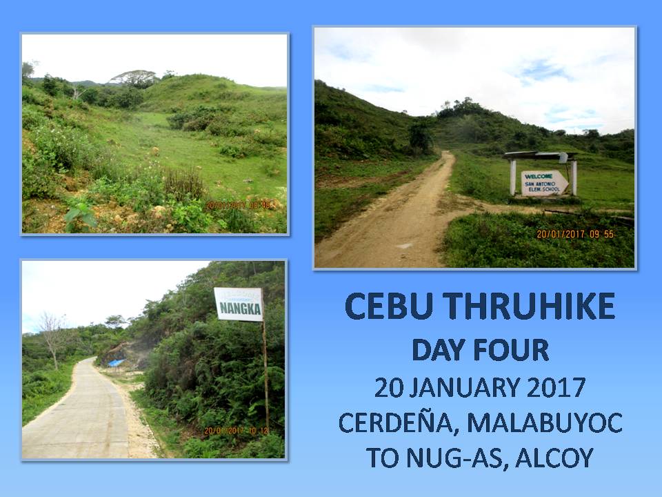
THE THRUHIKE JOURNAL: Days 4 and 5 (Cerdeña to Mantalongon)

DAY FOUR ::::: IT IS GOOD TO SEE SUNRISE after three days of moody early mornings. It rained the whole night but it was not that cold. The forest protected us from the elements. Although there was light rain today, it is so-so and is not bound to stay for long. I touched my wet clothes that I hanged under the canopy sheet. Partly-moist but wearable just the same. The Lorpen socks are now better than the time I removed it yesterday. This would be its last day of use and would probably be worn again on the northern leg of the Thruhike. Today is January 20, 2017.

It is 06:00 and I decide to tour the campsite for a good place to call in nature. When I returned, Jonathaniel Apurado is holding a pot that hot water is ready for coffee. Same breakfast fare of Knorr soup and rice as was done in past mornings. We break camp at 08:12 and it is a very very mild day. We would be walking on roads where, before, were trails. I may be a romantic but I am also a realist. Gone are the days when life was difficult for mountain residents. The presence of roads are a blessing for them, removing them from isolation, having access now to the economy of the lowlands, wide opportunity for education and better income which they could not wrestle in the past.


Despite the roads, the scenic views have not changed. The deep valleys on both sides are filled with seas of clouds after a rain. There are such few places in Cebu where you could view, while walking, both the western coastline, which includes Tañon Strait and Negros Island, and the eastern coastline, where you can see past Bohol Strait, Bohol Island and Siquijor Island. The route follows a narrow range of mountains, skirting two opposing big river systems, that connect the Southern Cebu Mountain Range, that start from Barili to Alcoy, to another mountain range in Oslob which is dominated by Mount Bandera.

A lone Brahminy kite flew over me and it circled overhead riding the thermals as I was about to make my way down to where this new road would join the road at Upper Beceril, Boljoon. We turned left and rest instead at San Antonio, Boljoon, at 09:25 near where we could replenish our water bottles. This is the road that goes to Nangka, Boljoon and this is the road where so much verdant hills are seen at closer distance on both sides, separated by narrow strips of farms. It is unpaved for the most part. Another scenic stretch which goes all the way to Nug-as, Alcoy.


We arrive at Nug-as at 11:35, hours ahead of schedule. We cannot just proceed to the next destination, which is in Mantalongon, Dalaguete, even if we are capable of doing it today. We cannot just alter the order of things this time just because I have the upper hand. There are times where you would have to honor what is on the itinerary and, for that matter, we would have to stay at Nug-as for the rest of the day. I have guests who would arrive later and we also have to meet our supply team tomorrow afternoon at Mantalongon. Good sense dictates that we would have to follow the itinerary to the letter.

The early arrival would do well instead for our bodies so it could recover from the hike of four straight days. This is another phase of the Thruhike where you would have to balance things out since the body could not bear the punishment for long. Remember, we still have 23 days more of walking. I do not want ourselves getting burned out halfway to the end or giving up somewhere along the way to injuries. Besides, I have a couple of sore toes to look over and a pair of shoes to dry. Considering all these, I sent a message to the Alcoy Police Station informing them of our presence.


We proceed to the barangay hall and asked permission to stay. It was not difficult to obtain since the one assigned today was someone who knew us from last time. We tied our hammocks on the same places where we fixed it last time. We do not have to use the sheets since there is a roof. We eat for the very first time a hot noontime meal of local noodles, the extra I carried just in case. I rehydrate a lot of liquid from powdered juice and Extra Joss and tuned in to an FM station signal coming from Negros Oriental. It was a very relaxing afternoon just lying down on a bamboo cot which the body really needs.

I would have stayed on the cot long but I have to find a cellular phone signal. We do not know if the GPS tracking device provided by Galileo Satellite Control System Philippines is transmitting our geolocations to them. The problem is that the only place where I could catch cellular signals here is on a waiting shed located 250 meters away. Photos and information from Day One to Day Four would be sent by my Lenovo A7000 smart phone and have to be posted in my Facebook wall to update my wife and family, my friends, my sponsors and my followers. It was slow at times when the signal appeared on a single bar and disappears from time to time. For text messages, I relied on my Cherry Mobile U2.

At 17:00, a police car from the Alcoy Police Station, led by PO1 Regidor, arrived to see how we are doing. They were sent to assist us if ever we encountered difficulty in finding our way in their area, which did not happen anyway. They stayed until 19:30. When we were on our own, we commenced our dinner of Korean spicy noodles with a sprinkling of shredded dried squid, sweet potato leaves and dehydrated seaweeds. We were well rested and waited for our friends to come but somehow they got delayed. We slept instead when the clock hits 22:00.

Distance Walked: 11.55 kilometers
Elevation Gained: 839 meters and a low of 359 meters

DAY FIVE ::::: JONATHANIEL APURADO WOKE ME UP at 05:00 that our guests have arrived some three hours ago. I am sure they would be tired so I let them rest for a couple of hours more. They have set up shelters in a car porch just a few meters away from the building where we are housed. They are Jingaling Campomanes, Mark Lepon, Christian Tan and Glyn Formentera and all belonged to the Camp Red Bushcraft and Survival Guild. Their presence and participation are more of supporting the Thruhike. They would engage in a dayhike with us today – January 21, 2017, from Nug-as, Alcoy to Mantalongon, Dalaguete.

Jon had taken over the cooking and there is Knorr soup and rice, boiled quail eggs and coffee. After breakfast, we took down our hammocks and stuffed all our things inside our backpacks. I changed into a new pair of undershorts and a clean pair of Kailas socks. The Jack Wolfskin shoes are now dry as well as my “uniform”. We are now ready to start Day Five except that our guests were still asleep. We shook them awake at 08:00.


We all leave Nug-as at 09:25 and this was the most late that the Thruhike had started. I have an additional cargo, ten small bottles of Yakult Cultured Milk, courtesy of Jingaling, which I carried inside a plastic bag with either hand. The sun finally appeared but not that scorching. January and February are the best time to engage in a Thruhike here in Cebu. You will be facing the cold winds that the northeast monsoon would bring in from the icy winters of Japan, Siberia and China. The sun would slightly be at your back since winter solstice changes the angle of its shadow.

We cross the boundary into the Municipality of Dalaguete and the village of Catolohan at 10:45. A lone Brahminy kite appeared in the sky, this time, much nearer. We arrive at Nalhub, Dalaguete at 12:10 and stopped for our noonbreak. Jon and I subsist on our food supply while the rest make use of theirs. Cold bottles of Sparkles cured those parched throats. Afterward, I shoot a text message to the Dalaguete Police Station and informed them of our activity, providing them our names. This is now a necessity since our party becomes bigger and noisier and it might send wrong signals to locals.


After an hour, we proceed on our hike and passed by Langkas, Dalaguete at 14:00. The hills here becomes like those seen around Osmeña Peak which is good as scenic attractions. The road goes up and up but I kept on going without stopping. I have taken my regular doses of one Enervon Multivitamin capsule and two Herbalife Natural Raw Guarana capsules each day and these might be the reasons I packed so much power today? Perhaps, but it is too early to tell. The long rest of yesterday might have to do with it.

Anyway, I arrived first at the Mantalongon Vegetable Market at 15:00. I expect to be here at 16:00, enough time to receive my supply team who will arrive at 17:00. As soon as everyone were all accounted for, we walk to the short distance to the barangay hall of Mantalongon. We are expected today by their officials and we were provide the free use of a building with toilet and running water. Just a few minutes after us, the Toyota pickup of the supply team arrived very early. Driving is Markus Immer from Switzerland with passengers Ernie Salomon, Justin Apurado and Glenn Pestaño with son.

They are also with the Camp Red Bushcraft and Survival Guild and how glad I am of seeing all of them, giving their support wholeheartedly of the Thruhike as volunteers. I could not ask for more. The supply team had brought bread from Park N Go Bakeshop, courtesy of Randy Salazar, aside from our daily fare of food and fuel for the alcohol burners. Markus also brought two boxes of small brownie cakes baked by his wife Analyn as his personal contribution. I shared what we have with the barangay officials of Mantalongon.


We left for a while the barangay hall and proceed to the market to eat early dinner at 16:00. We found one local restaurant big enough to accommodate all eleven of us. It was the first time in the Thruhike that Jonathaniel and I eat food that was not our cooking. Glad that the itinerary brought us to Mantalongon and break that monotony. Again, Markus chipped the bill and we go back to our billeting area. The supply team left at 18:00 while Jingaling, Mark, Christian and Glyn decides to stay with us. They still cannot decide how they would spend the day tomorrow – a Sunday.

We partied in the room provided for us with the brownie cakes, juice and Korean spicy noodles. I took a bath for the very first time after five days and washed my upper “uniform”. Mantalongon is famous for its cold weather and that is why it is called as Cebu’s “Little Baguio”. The guys even had a “blade porn”, a bushcraft tradition of exhibiting all knives in one place – a sort of pageantry. Then the activity transforms into a pageantry of first aid kits and another for fire kits. My Term-a-Rest sleep pad proved its efficiency by providing me a good night’s sleep.

Distance Walked: 13.65 kilometers
Elevation Gained: 779 meters and a low of 603 meters

Document done in LibreOffice 5.2 Writer

Sunday, January 22, 2017

MAN-SIZED HIKES XXIII: Nug-as to Liloan Point

IT IS ALMOST OVER. Just one segment more and the CEBU HIGHLANDS TRAIL PROJECT will be all over. The Year 2016 will always be a very memorable year for me. Kind of busy. Busy of doing things that I loved most like travel, teaching, blogging, humanitarian work and explorations. I had put to history Segment IV, Segment VI and Segment VII and, mind you, these were not easy walks. It resulted to an estimated total of 190 kilometers walked in just a single year, not counting Segment VIII yet.

Segment VIII is that walk from Upper Beceril, Boljoon to Cebu’s southernmost tip - Liloan Point, Santander. But, me and my Exploration Team will start from Nug-as, Alcoy instead and I gave just four days for this exploration hike. Can you dig that? It is not impossible, you see. When you are focused on something, everything can be done. I wished outdoorsmen with a purpose will be inspired by this and would develop the ability to replicate Cebu in their native Palawan or Negros or even combining Samar and Leyte.

Today, September 21, 2016, the Exploration Team composed of this writer, Jonathaniel Apurado and Justin Apurado are on a final mission. We are all pepped up and we are grim and serious. We know not what lies ahead after Boljoon but, definitely, we will try all routes where there is a good sense to walk. We know we would be at Oslob, at Samboan and at Santander a day or some days after but we know not if we will be at Malabuyoc or at Ginatilan. That remains to be seen.

We were all buoyed up by the success of Segment IV last January, of Segment VI last February and of Segment VII last month, even though we aborted this at a point when we were almost at the end. It was not a big deal. We could return any day to finish that short stretch. We were also on a high morale for our benefactors delivered when we needed it the most. Without them, maybe it would take another two years to complete this Project. I will deliver the CEBU HIGHLANDS TRAIL in January 2017 and that is a promise that I will fulfill.

Notable among our sponsors who provided funds and very useful gears and equipment are Titay’s Liloan Rosquillos and Native Delicacies, Alvin John Osmeña, Aljew Frasco, GV Hotel Philippines, Silangan Outdoor Equipment, Jonathan Blanes, Glen Domingo, Alan Poole, Jose Neo, Tactical Security Agency, App Ops Philippines, Lester Padriga, Harold Butanas, Lavilles of Australia, Bakhawan Beach Home, Melo Sanchez, Glenn Pestaño, Amaya Montecalvo, Marc de Egurrola and Markus Immer.

Not to be outdone, the following had contributed to the CEBU HIGHLANDS TRAIL PROJECT in the form of services, perishable goods and their acknowledgments. They are Drinox’s Kitchen, the Quijano Family, Jeremiah Dayto, Matthew de Leon, Mountain Stories Blog, Ham Radio Cebu, the Mountain Climbers Alliance of the Philippines, the Camp Red Bushcraft and Survival Guild, PAC Gear, and the Philippine Mountaineering Blog.

All that is or what had been, with regards to the CEBU HIGHLANDS TRAILS PROJECT, are chronicled in WARRIOR PILGRIMAGE as the Man-Sized Hike series. This is the blog that inspired the exploration and this is the exploration that exposed the blog to more readership following. Below is the itinerary of the days, time, events and other useful information where the Exploration Team boldly finished Segment VIII in three days instead of the four days allotted to it:

SEGMENT VIII, CEBU HIGHLANDS TRAIL PROJECT
NUG-AS, ALCOY TO LILOAN POINT, SANTANDER

FIRST DAY
SEPTEMBER 21, 2016


04:30 – Leave Cebu South Bus Terminal, Cebu City for Alcoy by bus.
07:00 – Arrive Poblacion, Alcoy. Take breakfast in town proper.
07:15 – Leave Poblacion for Nug-as, Alcoy by motorcycles.
07:50 – Arrive Nug-as. Prepare gears, tighten straps.
07:55 – Leave Nug-as for Nangka, Boljoon. Pace: Moderate to fast. Weather: Warm with cloudy skies.
09:15 – Arrive Nangka. Rest to repair external frame backpack of Justin.
09:20 – Leave Nangka for Cerdeña, Malabuyoc. Pace: Moderate to fast. Weather: Warm with cloudy skies.
09:45 – Arrive Cerdeña. Chance meeting with village official and make courtesy call.
11:00 – Leave Cerdeña for San Antonio, Boljoon. Pace: Slow to moderate. Weather: Very warm and sunny.
11:30 – Arrive San Antonio. Rest and rehydrate. Coffee break with snacks.
13:00 – Leave San Antonio for Cansaloay, Oslob. Pace: Moderate to fast. Weather: Very warm and sunny but with thunderstorms in the middle of afternoon.
16:10 – Arrive Cansaloay. Courtesy call on village head but we were refused audience. 16:45 – Eagle One decides to make a stealth camp in darkness on an unfinished house in vicinity. Dinner is crab meat soup, rice and fried chorizo. Strong thunderstorms east and west of us. Sleep on ground with shelter wrapped like blankets expecting both storms to pass over our camp.
20:00 – Taps.
Distance Covered: 15.3 Kilometers but only 9.7 Kilometers is officially recognized.


SECOND DAY
SEPTEMBER 22, 2016


06:00 – Wake up call. Immediately break camp. Proceed exploration for another route to bypass Cansaloay and climb Mount Bandera instead. Pace: Slow. Weather: Cool and cloudy.
07:00 – Arrive at a natural spring on the way to Mt. Bandera to rest and rehydrate and to prepare breakfast of rice and egg omelet with sliced chorizo Bilbao.
08:00 – Continue exploration. Chance meeting with a village official of Cansaloay and decide to inform our presence and purpose which turned out very well.
09:00 – Arrive Mt. Bandera. Propagated VHF signal using a Cignus V85 portable radio with stock antenna at 5 watts power to a repeater tower of Ham Radio Cebu located in the Babag Mountain Range, Cebu City, 118+ kilometers away. Communicated successfully with amateur station DY7EYN.
09:20 – Leave Mt. Bandera for Manlum, Oslob. Pace: Moderate to fast. Weather: Very warm and sunny.
10:55 – Arrive Manlum. Rest and rehydrate.
11:30 – Leave Manlum for Can-ukban, Oslob. Pace: Slow to moderate. Weather: Very warm and sunny.
12:35 – Arrive at the Vincent de Paul Hermitage. Rest and rehydrate. Prepare meal of spicy noodles and rice.
14:15 – Leave Vincent de Paul Hermitage for Cañang, Oslob. Pace: Moderate to fast. Weather: Warm and cloudy.
15:45 – Arrive Cañang. Make courtesy call to village head at his home. Invited to a fiesta dinner later. Set up hammocks and shelters at a copse of trees.
17:00 – Failed to propagate VHF signal this time to Cebu City even when a transmission coming from DX7CBU was very audible.
19:00 – Dinner at the home of the village official.
21:00 – Taps.
Distance Covered: 16.9 Kilometers.


THIRD DAY
SEPTEMBER 23, 2016


06:00 – Wake up call. Start cooking fires and breakfast.
07:45 – Leave Cañang for Monteverde, Samboan. Pace: Moderate to fast. Weather: Warm with sparse clouds.
10:05 – Arrive in the vicinity of Monteverde. Rest and rehydrate.
10:30 – Leave Monteverde for Cabutongan, Santander. Pace: Moderate to fast. Weather: Very warm and sunny.
11:45 – Stop at a crossroad of three rugged roads. Rest and rehydrate. Start cooking fires and lunch.
12:45 – Proceed hike. Pace: Moderate to fast. Weather: Very warm and sunny.
14:45 – Arrive Cabutongan. Rest and rehydrate.
14:50 – Leave Cabutongan for Liloan, Santander. Pace: Moderate to fast. Weather: Very warm with sparse clouds.
15:30 – Strong thunderstorm overtook us at Bunlan, Santander. Fog caused whiteout and obliterated trails and landmarks at five meters beyond. Have to stop at one point.
18:00 – Arrive the national highway in Liloan. Proceed to Liloan Point despite pain in muscles and feet.
18:30 – Arrive Liloan Point. Rest and rehydrate. Dinner at port restaurant.
20:00 – Leave Santander for Cebu City by bus.
22:30 – Arrive Cebu South Bus Terminal, Cebu City. Terminate exploration.
Distance Covered: 19.7 Kilometers.


TOTAL OFFICIAL DISTANCE COVERED: 45.30 Kilometers

When darkness overtook us at a road corner fronting the national highway in Liloan, Santander, there really was no stopping even as we knew we still have a day on our schedule left, a day good enough to nurse our aching muscles and sore bones and our tender feet soles. We all felt the nagging pains and the obtrusive weight on our backs telling us to stop but it was just about a half kilometer to Liloan Point, the culmination of our collective sacrifices. IT IS OVER!

For me it was more than five years’ worth of painstaking planning and labor that found many skeptics and a few dissenting voices, overheard or not, from an older crowd who thought they were God’s gift to Philippine outdoors. Creating a route along the length of Cebu is not my original idea and it had been there for the taking right after Judge Menmen Paredes abandoned it. These same people could have taken up the slack but they did not. They were just busy building up their hype and making money from it. They have all the chance but they were not the resilient kind.

I have gained back REDEMPTION and ACCEPTANCE of my place in the outdoors with completion of this bone-jarring project called the CEBU HIGHLANDS TRAIL. It is beyond my comprehension if I were to gauge this on the very first day I started this thing, which was a dayhike from Lutopan, Toledo City to Guadalupe, Cebu City on February 20, 2011. It was impossible, logistics-wise, but I have chopped this beast into segments and sub-segments at my own pace and tamed it and I have made history and there is no denying that.

Even as I sifted the sand along a shore in Santander, my mind is working on the unfinished 7-kilometer stretch in Daanbantayan that was denied me last month which I will cover on the next few days and that Test Hikethru of the CEBU HIGHLANDS TRAIL in January 2017, right after the Sinulog Festival. The CEBU HIGHLANDS TRAIL is my gift to the Cebuanos, especially to the dozens of outdoor groups who are not under the yoke of one super organization. This is for you guys. This will be your playground soon.

The finished CEBU HIGHLANDS TRAIL is not perfect for it trudged on a lot of roads where it used to be trails. When I started on this thing, the Cebu Provincial Government was already clearing ground for their Cebu Trans-Axial Highway. A lot had been paved and I could do nothing about it and roads are a blessing to residents of these remote places. Although I am able to overtook and finished my project before they did, it was not what people expected it to be. It could be refined though in later years. I just made a template for the future.

Testing and propagation of radio VHF signals as a side event of the CEBU HIGHLANDS TRAIL PROJECT is a necessity since it gives hikers the flexibility of communicating to stations from places where it is deemed remote and beyond the coverage of cellular signals. As a licensed ham, this is a necessity. It places responders a better advantage of locating lost hikers and would hasten response time. My thanks to Ham Radio Cebu and to Mr. Ferdinand Mercado of the Municipality of Alcoy for allowing Eagle One to ride on in their repeater stations.

It was my first time to encounter unusual thunderstorms in all my exploration hikes of the CEBU HIGHLANDS TRAIL PROJECT and it happened to us twice at Cansaloay, Oslob and Bunlan, Santander. The first one on the first night, two storms were approaching towards our campsite coming from the east and west. Just when we were about to receive the full brunt of their furies when they clashed, it disappeared, leaving us a very peaceful night and starry skies. The second one on the third day came from the land mass of Negros and unleashed its wrath obscuring trails and landmarks in a complete whiteout.

The present provincial police director, PSSUPT Jose Mallari, is a very thorough officer who does not let this small activity let slip from his attention. I was provided assistance by his staff and I was able to liaison with all the police stations that has jurisdiction on the routes I would take. It was a very big help on my part and it removed the difficulties that I could have had if there was no such gesture. I did encounter a slight problem in Cansaloay but it was not a big thing compared to the ones I encountered in Mabuli, Tabogon and in Lanao, Daanbantayan during Segment VII.

The CEBU HIGHLANDS TRAIL is now open and ripe for the taking this January 2017. I would be bringing Jonathaniel Apurado again with me since he would be the only one available among the Exploration Team and it would be another round of looking for another set of sponsors. The Test Thruhike is a month-long activity, about 32 to 35 days, and demand resupply of food in designated cache areas. Someday you will walk the CEBU HIGHLANDS TRAIL and you will be proud to walk in it. Someday.

Document done in LibreOffice 5.2 Writer

Thursday, January 7, 2016

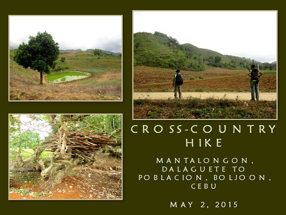
MAN-SIZED HIKE XVI: Mantalongon to Boljoon

AFTER FINISHING SEGMENT III of the CEBU HIGHLANDS TRAIL PROJECT last February 21, 2015, I decide to prioritize Segment V over Segment IV. Segment IV may have been scheduled first for October 2015 over the other but it is long, difficult, demanding of strength, skills, patience and time. It flows north from Mount Manunggal to Taguini, Carmen and would pass by places where many years ago were considered dangerous for mainstream outdoor activities.

On the other hand, Segment V, which I had first scheduled in the first quarter of 2016, is the shortest and the easiest and would be fine if I do it ahead of Segment IV instead. It requires no special considerations and I do not mind of the short space of time for its preparation after I had set the schedule for May 1, 2 and 3, this year. This route would link with Segment III and was to terminate originally at Nug-as, Alcoy but I lengthened it to Upper Beceril, Boljoon instead.

I pressured myself to end the exploration phase of this ambitious project in 2016 and make the CEBU HIGHLANDS TRAIL available to the public by 2017. I have done this almost singlehandedly and I am determined to finish this to the end even if I am left with rags to wear. What you do not know is that I will leave a legacy of dots in a box – a template – so others who will follow after me would refine the CEBU HIGHLANDS TRAIL as a first-class long trail that would attract international backpackers and encourage local ones to enjoy their own mountains.

Today, May 1, I am embarking on the fifth segment of this Project. I already had a dedicated Exploration Team and had prepared well the member’s stamina, including the basic items that the Team need. I need this Team to be better prepared and organized than the previous ones I led so as to lessen waste of time. The sacrifices and preparations had worked well during Segment III where the Team had shaved a day from its original four-day schedule.

I will lead again the Team into places where many mainstream outdoors people have not gone into before. There is more to Cebu and adventure can be most enjoyed here horizontally instead of vertical ascents. This is a three-day hike that will start from Dalaguete and, hopefully, would end at Boljoon. I will follow a route that will surely pass into Alcoy and, probably, might stray into either Alegria or Malabuyoc.

After waking up at 02:30, I walk out of my house an hour later to the 7Eleven Convenience Store located across the Cebu South Bus Terminal and waited for the rest. Jonathan Apurado, a marine biologist and an inactive mountaineer, came with his son Justin. Justin is an engineering student of a local university and dabbles into bushcraft and parkour. Not available this time is Jovahn Ybañez, a struggling ultramarathoner, designated as reserve.

As in every organized explorations, there is the Base Support Team. Its primary function is communications and assistance. It will monitor the progress of the Exploration Team and will give updates on weather to the Team and informs the outdoors community in Facebook. Chad Bacolod, a good communicator from Naga, will man the desk again. Another crew, Jhurds Neo, of the Camp Red and Bushcraft and Survival Guild, will be on standby and would be mobilized when needed.

The Team, will carry a banner that describes our activity as well as the logos and names of sponsors. These are GV Hotels, Silangan Outdoor Equipment, Titay’s Lilo-an Rosquillos and Native Delicacies, Tactical Security Agency, PAC Outdoor Gear, Jonathan Blanes, Glen Domingo, Boy Toledo and Glenn Pestaño. Also included are entities who contribute to the Team by other means like Camp Red, Mountain Climbers Alliance of the Philippines, Ham Radio Cebu, the Philippine Mountaineering Blog and the Warrior Pilgrimage Blog.

The elements of the Team are proudly wearing the team uniform jerseys provided for by Silangan with the name of the CEBU HIGHLANDS TRAIL PROJECT emblazoned on the front. Silangan Outdoor Equipment is my official outfitter since I endorse their products through my Warrior Pilgrimage Blog and in fora where the outdoors community interact. I am wearing their Greyman Hiking Pants and carrying their Predator Z Tactical MOLLE Backpack.

Aside that, the CEBU HIGHLANDS TRAIL PROJECT is officially sanctioned by the Cebu Provincial Government as a legitimate outdoor activity that would help them identify places where adventure tourism would be developed on the once-remote mountain areas of the island. This, after my meeting with the Honorable Grecilda Sanchez, board member representing the Third District, and Ms. Mary Grace Paulino, the provincial tourism officer.

The following are the narrative of events in chronological order that tell the whole picture of SEGMENT V, CEBU HIGHLANDS TRAIL PROJECT:

DAY 1 – May 1, 2015


  • Leave the Cebu South Bus Terminal at 07:00 by bus bound for Dalaguete. We were delayed departure by two hours due to a good number of vacationers taking advantage of a long weekend.
  • Arrive at Dalaguete at 09:30, transferred to motorcycles-for-hire.
  • Left highway for Mantalongon Vegetable Market but delayed further by 45 minutes because of road clearing and construction.
  • Arrive at Mantalongon, Dalaguete at 10:30 and then take a quick breakfast.
  • Start of first day hike. Leave Mantalongon Vegetable Market at 11:00 for Alcoy by an alternately paved and unpaved road known as the “Vegetable Highway”. Pace: Moderate. Weather: Warm and sunny.
  • Starts communicating with Base Support of our progress by radio, through a frequency provided by the Argao civic radio group, and by mobile phone. Exploration Team use EAGLE ONE as its callsign while Base Support use EAGLE BASE. Radio equipment in use is a Cignus V85 UHF/VHF Portable Radio Transceiver but radio contact weak as well as by phone.
  • Pass by villages of Langkas at 11:40 and Nalhub at 12:20 and stop at the village of Catolohan at 13:05 to to rest, rehydrate and eat bread from a small store.
  • Resume hike at 13:25 and proceed to somewhere in Alcoy. Weather: Partly cloudy.
  • Cross boundary into Nug-as, Alcoy at 14:00 and pass by the community of Bulalacao.
  • Arrive at the village center of Nug-as at 15:00. Make courtesy call to head of village and ask permission to spend night at their multi-purpose building. Prepare coffee then supper. Food are carbonara, asparagus soup and milled corn. Dinner at 18:00. Weather: Cool. Taps at 20:30.
  • ESTIMATED KILOMETERS WALKED: 12.9

DAY 2 – May 2, 2015


  • Wake-up alarm rang at 04:45. Prepare coffee then breakfast. Food prepared are fried chorizo Bilbao, scrambled eggs, asparagus soup and milled corn. Breakfast at 08:00.
  • Start of second day hike. Leave Nug-as at 09:00 for somewhere in Boljoon. Pace: Slow to moderate. Weather: Partly cloudy.

  • Stop by community of Liptong at 09:10 to drink fresh coconut wine offered for sale.
  • Resume hike at 09:20. Pace: Moderate to fast. Weather: Partly cloudy.
  • Cross boundary into Nangka, Boljoon at 10:30. Radio transmission unsatisfactory.
  • Pass by village of San Antonio at 11:15.
  • Stop by small store at the community of Calot at 11:50 to rest, rehydrate and eat bread.
  • Resume hike at 12:10. Pace: Moderate to fast. Weather: Warm.
  • Pass by villages of Upper Beceril at 12:50 and Lunop at 14:00.
  • Stop by a small store in Lower Beceril at 14:20 to rest and rehydrate.
  • Resume hike at 14:50 and arrive at the village center of Lower Beceril at 15:00 to pose before camera.
  • Resume hike at 15:05 for Poblacion. Pace: Slow to moderate. Weather: Partly cloudy.
  • Arrive at Poblacion at 16:50. Take a rest, rehydrate and eat an early dinner at a local restaurant.
  • Leave Boljoon for Cebu City at 18:00 by bus.
  • Arrive Cebu South Bus Terminal at 21:30.
  • ESTIMATED KILOMETERS WALKED: 20.48


This present Exploration Team had prepared so well in terms of physical conditioning that we shaved off a day of its original itinerary by our pace alone. Another factor which caused us to make this a 2-day affair instead of three is the presence of the “Vegetable Highway”. The existence of this little-known vein of progress actually is unknown even to some people living on the places we passed by. For most of those who lived along it, it is a blessing.

The Team officially have logged 33.57 kilometers of walking from Point A to Point B, basing upon the auto computation of Wikiloc, a web-based application which can either be manipulated by uploading GPS waypoints or by manual tracing of the route by a mouse but, I believed, we had logged more than what we were supposed to since the absence of a reliable transport system in the hinterlands of Boljoon forced us to walk down to the national highway located along the shore.

We each carried an average of 13+ kilos although we are observing light backpacking. Food, survival gears and our sleeping equipment had used up much of our cargo space. It is good that water could be had along the route even under a mild El Niño phenomenon. The places where we pass by are still abundant of water so there is no need to carry more than two liters of water. Along the route are natural springs which pour out cool potable water for man and creature alike.

On the other hand, folks see our presence on most of the places we passed, except at Mantalongon, Dalaguete, as unusual. They have not seen hikers or outdoorsmen or urbanites with backpacks before and they viewed us with suspicion until you break the ice by giving them a smile and a greeting. Ultimately a conversation begins, explaining your purpose, would make them see a bit but they cannot comprehend of why we walk when there are vacant seats on a few motorcycles passing by.

The completion of Segment V is but one step closer to my objective. The next routes would not be as easy as the finished segments nor would it ensure favorable conditions. Definitely, the next segments will not be a walk in the park and would demand navigation savvy from the Exploration Team, which that responsibility rests squarely on me. The CEBU HIGHLANDS TRAIL PROJECT from hereon goes on a high swing of difficulty but the team accepts that challenge by adapting to what it demands.

I have learned so much from the different segment hikes with different teams. This present team is so flexible and very much prepared for the physical challenges at hand that it had given me a great assurance that we can deliver the CEBU HIGHLANDS TRAIL PROJECT true to its schedule. Me and my team had explored and achieved fifty percent of the Project and I am quite elated about this. The next 50 percent would be different.


Document done in LibreOffice 3.3 Writer

Tuesday, April 1, 2008

THE BEST KEPT SECRET OF NUG-AS, ALCOY

I WENT DEEP into southern Cebu last December 29-30, 2007 together with my friends from CeMS (Cebu Mountaineering Society) to observe our traditional year-end climb and trek which we held, this time, at Nug-as, Alcoy.


Nug-as happened to cradle within her confines the last stand of old-growth rainforests in the island province of Cebu, of whose forested mountains, we thought, have been completely obliterated into baldy hills by greedy capitalists of the past.


And within its enclave is the haunt of the endemic bird -- the black shama or siloy -- whose habitat are losing ground elsewhere in the province due to unabated human intrusion and activity. The presence of the black shama in Nug-as have driven many ornithologists and nature conservation groups to conduct scientific observations and to collect data there, as well as to keep track of the bird’s population.


The black shama also added color to the cultural side of the municipality of Alcoy. They have adopted the lowly bird as their emblem wherein a town-wide mardi gras activity is held every August of each year to celebrate the town’s ecological biodiversity, of nature’s kindness and a bountiful harvest for their farms, and is aptly called as the Siloy Festival. (They even snared the first place prize of the Sinulog Grand Mardi Gras held in Cebu City on January 20, 2008!)


This climb (or hike) was my first after so many years of inactivity, marked by a sputtering series of ascents that were few and far between from each other. It has been more than eight years since I last trekked her trails and, I guess, hopefully, this trip would signal my renewed romance of trail hiking and mountain climbing which I have placed in the backburner of my mind owing to the pressing necessity of surviving and feeding a family.


From my dusty storage bin came out my old reliables: a 15-year old Habagat Venado II backpack, a heavy Chinese-made cotton sleeping bag and a pair of Coleman hiking shoes. Old essential equipments that should have rested on their laurels which I am wont to let go. They were my old companions on many trails and campsites of a passing era. They all told great tales of great climbs with me in the past. They have a soul of their own. They are irreplaceable. They reflect my character: old school mountaineering sense.


But before reaching Alcoy, I happen to espy a low-flying Brahminy kite (banog) hovering just about five feet above the ground in Simala, Sibonga as the bus I rode in passed by. The presence of my raptor at low-level flight gave me a hint that there’s gonna be a good weather on our journey today. Call it a hunch, a gut feel. True indeed, it had been raining at Nug-as for a month straight save for our trip today and the morrow after that.


I was with Dr. Abe Manlawe, Daddy Frank Cabigon, Ramon and Ann Vidal with their daughter Sierra, Glenn Domingo, Leo Glenn Lao, Joy Tongco, Grace Ventic, Julienne Rosales, Paeng Jura, Jon Consunji, Rosebelle Daculan, Lilibeth Initan, couple Loklok and Tata Caumeran, Andrew Flores and Jecris. We have guests who went along with us like Nick from Bulacan, Ronald from Consolacion and Doc’s niece, Maricel. A special guest, Eugene Abarquez, MFPI VP for Visayas, went along also.


This bacpacking affair was organized by Batch 2007 of CeMS and is coordinated in tandem with the Barangay Council of Nug-as, who provided us three forest wardens as our guides; and with Mr. Ferdinand “Nanding” Mercado, senior staff of the municipal mayor of Alcoy, who arranged our food, transportation from Poblacion to Nug-as and vice versa and, later, the free use of of the mayor’s own beach resort at Tingko right after the activity.


We started our trek at KMYLB (Kapunungan sa mga Mag-uuma sa Yutan-ong Lasang sa Bulalacao) headquarter at 12:00 noon of December 29. Once we got into the treeline, the trails became wet and slippery. On a small clearing under the canopy of trees where two trails forked, we took rest and ate our packed lunch at 1:00 PM.


Thirty minutes later, we proceed on, following the trail by which our guide had been leading us. Along the way, we discovered a live flying lizard nesting her three laid eggs on the trail itself. The mother lizard seemed to be aggressively alert to the sudden presence of “intruders” and kept watch over her unhatched brood while we gave her a wide berth as we passed by her nest, but not after documenting her with several mug shots from our digicams.


One wildlife which was conspicuously absent was the siloy. We asked our guide, Pol, why is that? He informed us that the bird is so shy and would hide at the slightest sound of our movements. He advised us to walk silently and, as if on cue, Ramon took center stage and suggested to us all, with actions to match, that we should start rehearsing the “siloy walk”, which elicited howls of laughter from all of us.


The first time I was here was in August 1999. Here, we walked the trails at Lower Bulalacao. Back then, there were monkeys high up on the trees chattering and eating among themselves unmindful of us humans passing below them. Some of them would drop their morsels of fruit they ate with. Siloy and other avians would dart to and fro from one tree to another. Time have changed all that or, perhaps, this trail at Upper Bulalacao are prone to intrusions by predatory humans, especially the kind who carried a rifle.


Back to the present, I am in the assault group, maybe, four or five persons behind our guide. Now, I get to feel the pace by which the guide exacted upon us. Slowly the old climbing machine in me began to grind its rusty gears to half throttle - just enough to maintain the speed and distance behind Doc.


I carried a heavy weight, not just in my backpack, which is already bursting at the seams, but, on the added weight with which my body have accumulated through all the years of living a sedentary-like lifestyle.


Along the way, I saw several sinkholes beside the snaky trails. Eight years ago, Rosebelle, Ben Lao and me explored one of those in a different area of Nug-as. It was easy going down, but, it was hell coming up on SRT (single-rope technique). You push 8 inches up and the jumars would slip 5-6 inches down unable to grip the rope made very slippery by mud. It sapped all my strength reserves then that I almost fainted on the trail after that.


By 3:00 PM, we finally reached the campsite on the top of Cambudlot peak where a bunkhouse for forest wardens is located. Julienne decided to go home for an urgent need and I was tasked to accompany her safely downhill and ensure that she gets to hop on a habal-habal ride for Poblacion. At the same time, I have to wait the food for dinner that was to be delivered by Nanding.


On the way down, Pol the guide, kept up a torrid pace which I was able to maintain as I was not carrying a backpack. During one of those downhill stretch, I failed to notice a clump of rattan palms growing amidst the trail and I got snagged by the spiny thorns scratching my whole right arm with it.


Nanding arrived just in time at around 6:30 PM with our prepared dinner in three kinds: calderetta, paklay and kilawin; and 150 pieces of rice balls or puso. Loklok and Tata were with Nanding and both of them accompanied me and Pol to bring the food to the campsite. Pablo, Nug-as barangay councilor, went also with us to assess the situation which he was tasked to oversee by their barangay council as chair of the environment committee.


We reached the campsite in less than an hour by way of a shorter route. I noticed the sole of my old Coleman hikers about to split away from the upper fabric that housed my not-entirely-pink pinkies! My shoes seem to say something like an “I-told-you-that-I'm-too-old-for-this-thing” scowl it gave me and I couldn't argue about the thing. I'll have to improvise in the morning to keep my shoes intact (and my sanity!) by the time we go downhill for home.


Dinnertime came and food were served and everyone took his fill of the free meal, courtesy of Batch 2007. I splurged on calderetta, which was excellently done, and the kilawin, sliced and cut in “tanguigue” fashion, which tasted good on the palate. I could have made good use of a drop of strong drink to help digest those solids, but, since there was none opened yet at that hour, I have to contend myself without and, hopefully, my eyes don't get drowsy as it was crispy cold.


Good thing there was a refresher lecture about the Leave No Trace outdoor and backpacking ethics espoused by Glenn L, which made me forget for a while the idea of snuggling inside the warmth of my sleeping bag.


The beckoning comfort of the tent vanished altogether from my mind as an impromptu program was organized and we were divided into three groups to present entertainment numbers and to compete with each other. There are, however, no winners chosen but only one losing group, whose sole “punishment” was to cook breakfast for all participants and guests.


Ultimately, my group collected the ignominy of cooking the breakfast - with wide open arms and equally wide grins!


After that, Eugene played Santa and unpacked his bag to reveal a horde of cellphone holders and coin purses, under the local brand LAKAT®, which were all distributed to us all. Fireworks were released to complement our festive mood that night.


December 30 came at our campsite at Cambudlot and we were greeted by a beautiful view of the lower valleys swaddled in early morning fog. At an affordable height, it bestowed upon the viewer a panoramic sight of the hidden rainforest - still quite unknown to a great majority of Cebuanos!


One landmark that I remembered well was a very tall tree that hosted several nests of the Brahminy kite. Eight years ago, there were three or four kites then soaring around the tree affirming a still thriving biodiversity around Nug-as. Today, that tree still stands, but, it's occupants are there no more! Just like the primates and the siloy they have disappeared from their “homes”.


And we, of that night's losing clowns, started the task of boiling water for coffee and instant noodles, re-heating last night's leftover food and cooking additional breakfast. Everyone chipped in their canned goods and packaged food, albeit, to lighten their backpacks on their downward trek. Others elbowed their way to take over the slicing knife, spatulas and, what else, the task of cooking, which was rightfully ours! Wow, we appreciate their sympathy and helpfulness (lol).


Then someone suggested that the rules for next year should be revised. Instead of just cooking the meals, the losers should also wash the dishes! What say you, Paeng?


There was a slight drizzle as we ate our breakfast. A full arc of a rainbow appeared in the sky. No, two full arcs appeared and...Click! Click!...their images were captured in digital form. Rosebelle, Glenn, Grace, Ann and Jecris made sure of that.


Then time to fold the tents and leave no trace of our passing. I made sure my Colemans would give an optimum performance by binding the soles with an adhesive tape courtesy of Glenn L. At 9:00 AM, down we go in procession-like manner into the Alcoy-Alegria road, that cut a swath of asphalt ribbon to Nug-as in half. We walked a kilometer on the road towards our waiting transportation that would bring us to the lowest side of Alcoy - the beach at Tingko.


Some of us stayed, others went off early for Cebu City. While at the beach we savored the welcome warmth of the sea and refreshed our battered bones. Over bottles of San Miguel Grande and a half-gallon of fermented coconut sap (tuba) we enjoyed the breeze and the view of Alcoy's powdery-white sand beach with its clear-blue water.


Doc, Jon and me tried the small outrigger boat by paddling from shore to a floating hut (lagkaw) anchored to the seabed and around it and back. While Jecris, Andrew, Eugene and Daddy Frank coaxed an ember to life and grilled pork meat on glowing hot charcoal for our lunch.


By 3:00 PM, I bade goodbye to Alcoy one more time and I hope to see more of her secrets soon. I wished her beloved siloy would show on the trail and sing for us her famous melody.


Document done in RoughDraft 3.0, Trebuchet MS font, size 12.