Showing posts with label Samboan. Show all posts

Monday, March 1, 2021

2021-009 | PINOYAPACHE IN A TOURISM PROGRAM

IN 2019, THIS BLOGGER was part of a team of resource persons contracted by the Department of Tourism, Central Visayas Region, to train, educate and enhance community guides of the different local government units (LGU), whose tourism programs are focused on adventure or cultural or both. This national project is called the Tourism Industry Skills Program (TISP) and was implemented by every region since 2017.

DOT-Central Visayas did not fall behind and, in fact, it was running in full steam. Credit that to its Regional Director, Mr. Shahlimar H. Tamano, and the equally hard-working duo of Senior Tourism Operations Officer, Ms. Cynthia O. Monzon, and Tourism Operations Officer, Mr. Eli John Eduave. They were able to assemble a veteran team composed of tourism service specialists and outdoor educators and they were Ms. Agnes Tuling, Mr. Ruel Rigor, Ms. Rosebelle Daculan, Mr. Ramon Vidal, Mr. Randy Salazar and mister yours truly. 

Many aspiring community guides participated in the TISP. Those who passed the series of tests and evaluation given by DOT-Central Visayas are issued special tourism guide license, which scope are confined to the LGU where they belonged or recognized thereat as a community guide. The license gives the holder legitimacy to undertake work of a community guide and, therefore, protects the tourists and their LGU from fly-by-night opportunists. 

The following are the LGUs that have benefited from the TISP offered by DOT-Central Visayas. Each has its own existing tourism programs based on its identity which had already been carved from or associated with the landscape and the landmarks and these had made each LGU unique and worth a visit. This writer would add his personal observations, in italics, as you sift through each LGU on the visit of Team TISP. 

MUNICIPALITY OF BADIAN

Province of Cebu

August 17-24, 2019 

ATTRACTIONS: Kawasan Waterfalls; Matutinao River; Lambug Beach; Badian Island; Osmeña Peak; Candung-aw Peak and Tañon Strait. 

ACTIVITIES: Canyoneering/River Trekking; Swimming/Bathing; Picnic; Snorkeling; Hiking/Camping; Zipline Gliding.

TISP was held at Eskapo Verde, an eco-tourism resort located on an islet off Bugas, Badian. The area is conducive for learning since it is accessible through a 250-meter long bamboo walkway over an estuary where mangroves grow, far away from the Cebu Southwest Road. Accommodation for the DOT-Central Visayas TISP Team was also in Eskapo Verde. 5 stars out of 5.  

Eskapo Verde is a perfect magnet to develop and to include water sports, like kayaking and stand-up paddling (SUP), into the tourism map of Badian LGU. Besides, the five small islets and a half-buried shipwreck all in close proximity to Eskapo Verde is also another venue to develop a new tourism activity of mangrove kayaking. 

What a lot of people in Badian do not know is that the longest Camino de Santiago in the Philippines starts from their own St. James the Apostle Parish, located in Poblacion. This is a pilgrimage route that climb over the mountains to Dalaguete and goes north to Compostela, 175 kilometers away. This is patterned after the one in Spain and have been established here in Cebu since July 2017. It passes by the barangays of Dagatan, Malhiao, Sohoton, Tigbao and Santicon.   

CITY OF CARCAR

Province of Cebu

August 27-September 1, 2019 

ATTRACTIONS: Preserved Spanish Colonial Infrastructures; Carcar City Museum; Indigenous Food/Delicacies; Guadalupe Mainit-Mabugnaw National Park; and Theotokos Shrine. 

ACTIVITIES: Cultural/Historical Tour; Gastronomic Tour; Spelunking/Cave Tour; Hiking/Camping; Sightseeing/Birdwatching; Warm Water Bathing.

TISP was held in a vacant room of the new Carcar City Hall. The seminar is partly shouldered by the Department of Environment and Natural Resources, Region VII, because of the inclusion of the GMMNP in the city’s tourist mapping. Accommodation for the DOT-Central Visayas TISP Team was at Tatope Travel Lodge, located along the Cebu South Road, Carcar City. 1 star out of 5. 

Most people in Carcar City do not know yet that both the 400-kilometer Cebu Highlands Trail and the 175-kilometer Camino de Santiago pass by their city. The two long trails both enter Barangay Napo on the same way and exits from Barangay Calidngan at two different paths. 

On the other hand, Carcar City still has remnants of the industries that it had once depended on in the past. Instead of placing them in the dustbin of existence, why not include these into their tourist map. I am talking about leathercraft and bladesmithing. Why not fuse these two and develop a new tourism destination under “blade tourism”? 

MUNICIPALITY OF SAMBOAN

Province of Cebu

September 8-15, 2019

ATTRACTIONS: Aguinid Waterfalls; Binalayan Waterfall; Dao Waterfall; Preserved Spanish Colonial Infrastructures and Tañon Strait. 

ACTIVITIES: River Trekking; Swimming/Bathing; Snorkeling. Picnic; Cultural/Historical Tour; Sightseeing/Birdwatching.

TISP was held inside the session room of the Samboan Municipal Hall. Accommodation for the DOT-Central Visayas TISP Team was at Chelan Resort House, located along the Cebu Southwest Road, Poblacion, Samboan. 3 stars out of 5. 

The Cebu Highlands Trail established a campsite on a ridge of Barangay Monteverde. It would be best if the Samboan LGU would develop it into a camping area because of its proximity to a water tank. 

MUNICIPALITY OF SAN FRANCISCO

Province of Cebu

September 22-29, 2019 

ATTRACTIONS: Lake Danao; Paraiso Cave; Amazing Island Cave and Beach Resort; Timubo Cave; Santiago Bay; San Francisco Baywalk and Causeway; Indigenous Handicrafts. 

ACTIVITIES: Hiking/Camping; Zipline Gliding; Kayaking/Paddling; Picnic; Spelunking/Cave Tour; Swimming/Bathing; Sightseeing/Birdwatching.


TISP was held inside the function room of the San Francisco Multi-Purpose Cooperative, Poblacion, San Francisco. Accommodation for the DOT-Central Visayas TISP Team was at Dayon Lodge, also in Poblacion. 1 star out of 5.

MUNICIPALITY OF TUDELA

Province of Cebu

September 30-October 6, 2019 

ATTRACTIONS: Bukilat Cave; Buenavista Heritage Tree; Villahermosa Giant Clam Sanctuary; Tudela Mangrove Forest; Busay Waterfall; Makalabad Peak. 

ACTIVITIES: Spelunking/Cave Tour; Cultural/Historical Tour; Sightseeing/Birdwatching; Swimming/Bathing; Snorkeling; River Trekking; Hiking/Camping; Kayaking/Paddling.


TISP was held in the function hall of Villa Alicia Resort, Poblacion, Tudela. Accommodation for the DOT-Central Visayas TISP Team was also at Villa Alicia Resort. 3 stars out of 5. 

All blacksmiths in Tudela LGU still used improvised oven and blower and still produce the best blade tools that are used by farmers and homesteads on the islands of Poro, Pacijan and Ponson. It may be worth the effort to include these blacksmith shops into the tourist map of the LGU under the new destination of “blade tour”. It may be even viable if the three other LGU of the Camotes Group of Islands decides to join hands and save this dying industry. 

MUNICIPALITY OF ALICIA

Province of Bohol

October 9-16, 2019 

ATTRACTIONS: Alicia Panoramic View; Birhen Nature Resort; Cagong-cagong Cave; Princess Manan-aw Cave; Chocolate Cave; Alicia Schist Rock. 

ACTIVITIES: Hiking/Camping; Trail Running; Bathing; Sightseeing/Birdwatching; Spelunking/Cave Tour; Cultural/Historical Tour.
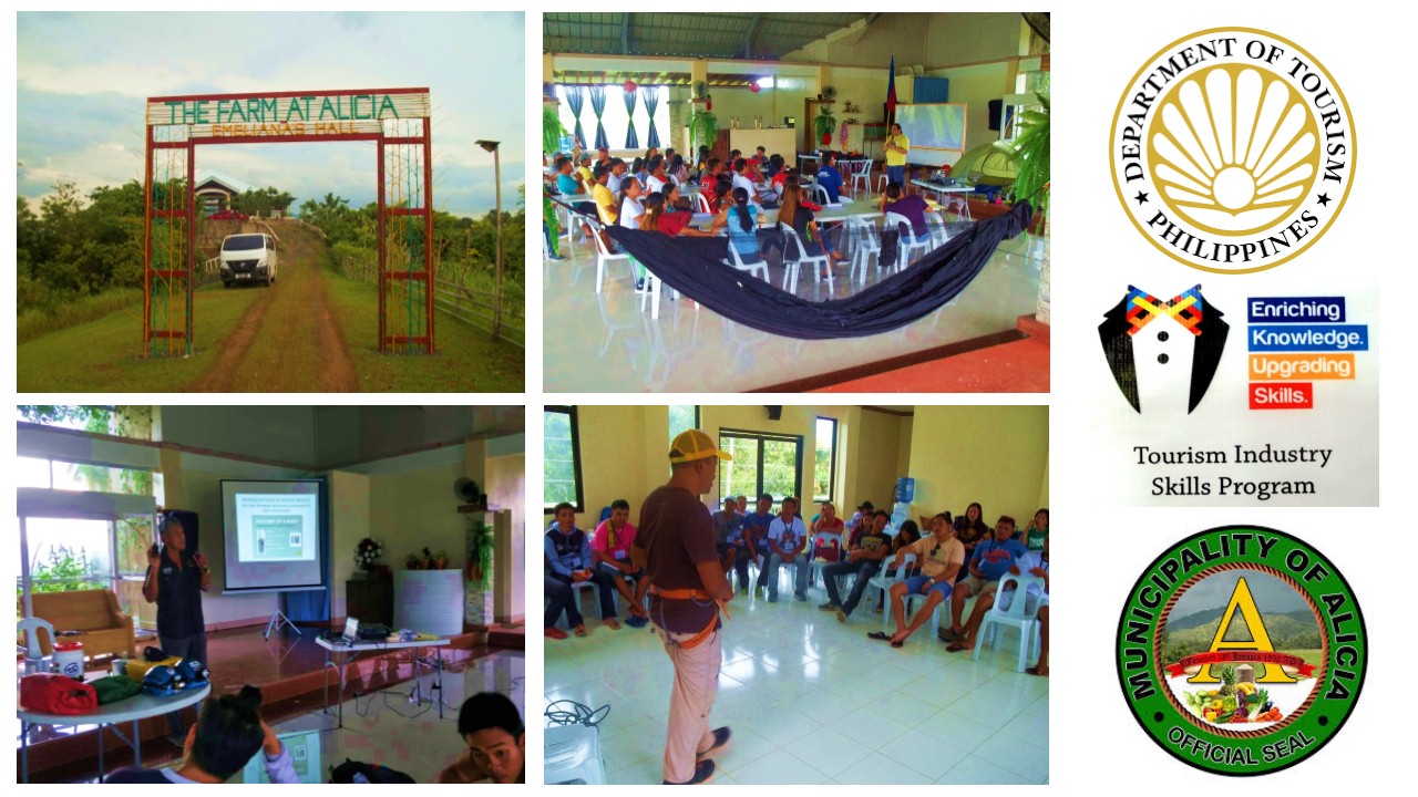
TISP was held, respectively; for the first three days, at The Farm in Alicia, Cambaol, Alicia; and for the rest of the week, in the function room of the Alicia Municipal Hall Annex. Accommodation for the DOT-Central Visayas TISP Team was also at the Alicia Municipal Hall Annex. 1 out of 5. 

=> => o0o <= <=


WHILE TOURISM MAY BRING in revenues needed by the LGUs, it has its downside as well. We have seen the decay that over-commercialization and over-development have done on so many places and are now shunned by most tour operators due to lesser tourists. The TISP is just not improving skills on the tourism operators but also considers the health of the environment of a destination as an integral part of development and the team emphasized that in our 2019 LGU tour.

Tuesday, May 9, 2017

THE THRUHIKE JOURNAL: Days 2 and 3 (Monteverde to Cerdeña)

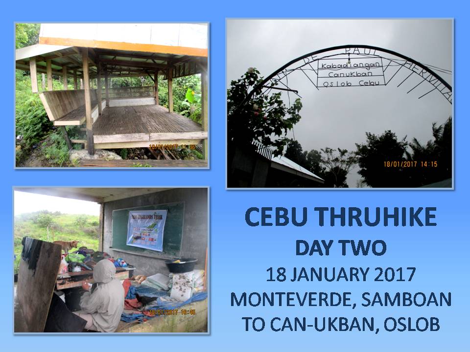
DAY TWO ::::: THE STRONG WINDS HAVE MELLOWED down while the monotonous tap-tap of the rain on my canopy have lulled me to laziness. It should be a cold morning but I am surprisingly warm. The Therm-a-Rest insulated foam pad which was provided by Michael Schwarz for the Thruhike have given me strange comfort which I have had not experienced before.  Indeed, I had a good night’s sleep free of worries but I have to rise from the comfortable capsule of my hammock.
 
I was amazed at our coverage of Day One.  We were not supposed to be camping here at Monteverde, Samboan yesterday but somewhere down short of here.  The first day adrenaline spurt might have to do with that.  Or that I intend to change the itinerary.  It is the latter but adrenaline and, perhaps, capsules of multivitamins and Guarana may have helped.  Here, we have a good water source and a perfect ground to set up hammocks and shelters.

It is 06:15 and I need to boil water for coffee.  Suddenly, my hands are afire.  Ants, known locally as “hakot”, have invaded the nooks and crannies of my backpack where I stashed my rice and everywhere on the ground and then my feet got stung and it was all over me quick.  They were working all night while I had that hangtime.  They were also on my Park N Go bread.  I gyrated to a tuneless dance and dragged my bag far, slapped it hard and shook off the tiny army.

 
I did have that coffee while watching over my Trangia alcohol burner doing its work on rice.  Jonathaniel Apurado, my buddy of this Thruhike, is cooking Knorr soup on his alcohol burner.  You might wonder how much food we carried for this journey?  We carried food good for five days only, intending to replenish our supply at Mantalongon, Dalaguete on Day Five, which would be on January 21, 2017.  We each carried a half kilo of rice, repacked in five plastic tubes weighing 100 grams each, and three packs each of Knorr flavored soups and another three for Korean spicy noodles.  Actually, I carried more for insurance if ever Murphy’s Law imposes its will on the Thruhike.

The warm Knorr soup mixed with warm rice on a cold morning is wonderful.  My food plan are soup for breakfasts, baked goods and energy bars for lunch and spicy noodles for dinners.  When we get a chance to pass by markets, we will change our diets but, basing on my food plan, this would be rare and few.  By now, you would get the idea of our eating habits for a month.  You know, planning the Thruhike is not easy.  You will have to study your itinerary long and hard before making it final, careful enough not to overestimate nor underestimate the distances between places found in maps.  When you have the itinerary, planning your meals are next.

The good thing about my itinerary is I could change it if I wished it.  I can enjoy this privilege because I have explored these places in segments.  Days One, Two, Three and Four are part of Segment VIII which I had passed by last September 2016 but we did that starting from Upper Beceril, Boljoon going down to Liloan, Santander and this Thruhike is going on a reverse, which is kind of tricky on your planned pace because it is uphill.  But Day One was spectacular because I changed it.

We leave the campsite at 08:15 just in time when curious locals visited us.  The wind began to pick up its strength and rain lashed at us but we still retained good manners to accommodate their questions and it turned out well and good.  One of those who came is Dominador Rodriguez, and we met him last time when we passed by here.  We followed him as we continue on our journey today, January 18.  Before I reached the boundary of Oslob, I informed their police station about our presence and our activity.  I might not get that chance for I know cellular phone signals ahead are absent. 
  
I do not feel tired nor I feel muscle pains from the labors of a forced march yesterday.  The amount of time walking among mountains done every Sunday for eight years have done wonders for my body and I have adapted well.  If this is to be a gauge then the Thruhike is good as done!  I have trained myself well even before this epiphany happened in 2011 but the greatest transformation is my mindset.  I might be older but I am better than when I was an invincible adventurer of the ‘80s and the ‘90s.

The trail passed by a well but we have already secured water.  We reach a paved road.  This same road goes down to Tumalog waterfall and to the coasts of Oslob but the one we are following is the unfinished Trans-Axial Highway which goes uphill.  The scenery begins to change when you are on higher elevations.  Valleys, farms, verdant hills, rocky cliffs and solitary huts dot the countrysides.  A Brahminy kite flew from behind me to the right and I take it as a good omen.  I tried hard to capture it with my camera but another one caught my attention as it called me with its shrill whistle.

 
For the moment, there is no other way to walk here but I see some shortcuts where it would bypass the pavements and it goes through forest trails.  Actually, you would not know these until you see a long bend or a hairpin turn and then you decide to explore a path which puts you on places where you most wanted it to be.  It goes perfectly well on three of such places because I was certain it would.  We reach Cañang, Oslob at 10:15 and rest at its barangay hall to talk to a local.  Although the building gave us warmth and protection from the rain and cold, we need to continue our walk and so have to leave this friendly village. 

The same road goes into more scenic scenery of long deep valleys on either side, choked with trees and approached by a series of low hills, farms and verdant meadows, landscapes which you would not know existed in Cebu.  The same Brahminy kites that I saw a couple of hours ago appeared.  By now, the weather turned mild with bit of sunshine.  We came upon a waiting shed at 11:25, at a place called Mohon, already part of Can-ukban, Oslob and we stopped for noonbreak. 

Since we were on higher ground, I decide to test the Versa 2-Way VHF radio on selected frequencies for Cebu City, Alcoy, Dalaguete and Argao.  Both Jon and I possessed amateur radio station licenses, being members of Ham Radio Cebu.  Cloudy weather, distance and mountains forbid me to come in contact with these repeater stations.  The rest is a good thing for it made me appreciate this structure at closer range than the last time I passed by here.

Well rested, we leave Mohon at 13:00 in a cloud of light showers. The concrete road is in good condition as it weave its way among hills and pocket forests which, to my mind, contain an enormous number of avian species.  From a distance, you will see this same road climbing up through more elevations and it would probably deter you when you walk it in another time.  The wet weather brought by a Low Pressure Area might have helped us in overcoming this obstacle but you will feel the cold as you go higher.

We arrived too early at the place where we are supposed to spend our second night, at 14:10, but it is pointless to go on under this uncooperative weather to seek shelter on another place.  We will just have to take advantage of the friendship we made with a couple who owned a concrete house which is located just across the Vincent de Paul Hermitage.  It is convenient for us to honor the itinerary this time, just in time to see Miguel Aniñon grind ears of corn with a millstone, which I caught in video.

We spend the rest of the day unloading our things to dry it out, together with our bags.  The hammocks were dry and that is the most important thing.  We do not have to worry about the rain since we tied it on the concrete posts of an unfinished concrete structure where there is a roof, although without walls, and owned by the Aniñon Family.  The location of their house, together with the hermitage, are located on top of a peak and we are, nevertheless, exposed to the spray of raindrops and cold wind.  That night, strong gusts and heavy downpour brought by the storm pelted our camp. 

Distance Walked: 10.37 kilometers
Elevation Gained: 754 meters from a low of 538 meters

DAY THREE ::::: THE COLD CREPT INTO MY SIDES where the Therm-a-Rest had not clasped me as it gave way to weight of body inside a hammock which had become soggy from the intermittent spray of moisture.  It was like that for the rest of the night and, here, early in the morning of January 19, I begun to wiggle out of my discomfort zone.  Jon had already started cooking the rice and boiled water for coffee on our alcohol burners.  The skies were still in a dour mood and it was raining.  The things that we dried yesterday, remained moist.

Fr. Carlo Curacot of the Vincent de Paul Hermitage came to pay us a visit after breakfast and asked of how are we doing?  After a while, he sent us warm buttered pancakes and, finishing it, we set out on our journey to the north.  The ground was wet and slippery but we decide to go against common sense by taking a steep shortcut downhill to evade a long bend of concrete road. We realized it was difficult to stay erect following this trail, more like a suicide mission, but we survived this unscathed.

 
An unpaved road is nice but trails are better.  Only, the trails to our next destination are in short supply.  When there is a shortcut, we took it and, most often, it is so muddy and slippery.  We stop by a small house with so many family members at 09:50 on a boundary between Oslob and Ginatilan.  A matriarch, Damiana Cariño, 72 years old and bent to so much time working in the fields, talked about her predicament of never receiving cash allocated to senior citizens from both towns.  We advised her to focus on the town where she is registered as a voter.  That is where most local funding is based on, of small towns where politics are so divisive.

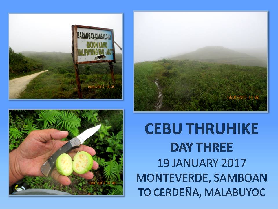
Another shortcut brought us to another stretch of unpaved road and a welcome sign says Manlum, Oslob and another says Cansaloay, Oslob.  Up ahead would be a shallow well fed by a natural spring.  It is a small marshy place and is one of the headwaters of the Laguinsan River which wind its way to the coasts of Oslob.  A trail goes up to a bald hill which goes up and up.  The rains had not abated, winds picked up strength as we gained elevation.  Fogs obliterate the landscape, making navigation a patchwork of guesses and tells.

Most of the time, I am caught off-balance by the force of the wind.  The Therm-a-Rest is slung across my shoulder to the front of my body and is the object of so much wind resistance so I have to clip it lee of the wind with my left arm.  Mt. Bandera would just be around there beyond my vision obscured by fogs.  As I go further, terrain which lay invisible begun to show its earthly appearance, blurry humps at first then in great details.

Now I am on the hump that is Mt. Bandera and we stop for a while to send out another propagation test to a repeater station of Ham Radio Cebu, found in the Babag Mountain Range of Cebu City, a distance of about 118-120 kilometers.  I am testing a Versa Duo VHF Radio, with stock antenna and 5 watts power.  The first stream of communications was received by station DY7EYN at 11:00 but was interrupted by bad weather and cut short.  The second one at 11:30 went out seamlessly and acknowledged by station 4F7MHZ.

Satisfied by the results of the worthiness of the Versa Duo in extreme weather conditions, we go down the trail towards Tigib Spring, another source of the Laguinsan River.  We arrive at 12:10 and enjoy our 50 minutes of noonbreak under the onslaught of streaming winds and whipping rain.  We munch on energy bar, biscuits, bread and mixed trail food.  I foraged ripe guavas and sliced it in halves with my Buck Classic 112 knife.

 
At exactly 13:00, we followed the trail that would join with an unpaved road, which would become one with a paved one, recently concreted.  This road goes on lazily uphill, twisting and bending forever towards the sky, passing by either at Malabuyoc or at Boljoon, again and again.  The good thing is the rain had abated for a while and there are no fogs to block your view ahead although the wind still ruled the higher elevations, especially at the most exposed areas.  At this stage, I informed both the Malabuyoc Police Station and the Boljoon Police Station of our presence in their area.

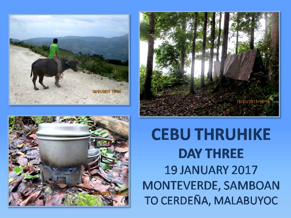
At a point where it is most elevated, the road begins to twist and bend downward.  Heavy rains have clogged up ditches with silt and pebbles, on some points, carrying whole culverts down the mountainside.  Landslides threaten a house below while cracks on elevated ground above roads is something you would not want to happen where people pass.  I have not seen one vehicle, not even the omnipresent motorcycles-for-hire.  But there is life here.  A boy rode the back of his carabao while a noisy party of intoxicated locals just came out from a house where there is a feast of some sort.

Schoolchildren walked their way home from school and some of them run at the sight of us.  Stories of child snatchers pervade everywhere and we fit the description of big bags to stuff children inside.  Cannot blame them for these places are indeed lonely which a newly-opened road could not change immediately.  In time, maybe they will get used to the sight of a backpacker.  I hope so.  The Thruhike opens you to different local cultures and different people who harbor different beliefs and, most of them, are talkative enough to tickle you with their simplicity.

By now, the road is eerily empty and silent.  I found a copse of mahogany trees which I have eyed before as a perfect camping site for hammocks.  It is now 15:30 and I do not know if we would get another opportunity to find a good place like this to camp up ahead.  This is perfect, although it is just ten meters away from the road.  It is slightly elevated, since we are at the shoulders of Mount Ablayan, and trees are growing near each other that could hide several shelters.  I got a light gray taffeta sheet and Jon has a brown laminated nylon sheet.  Both are of neutral colors and we are good in stealth camping.

Immediately, I tied the partly-moist hammock to separate trees to wick away moisture while I fixed over it my wet taffeta shelter.  Then I removed all the things inside the bag to let it all dry, carefully storing the food cache above the ground.  I fixed the drip lines at each end of the hammock in the event rain will come.  Set up my Trangia alcohol burner at a spot where I could comfortably sit, scratched the small ferro rod of an Advanced Pro Fire Starter over the alcohol fumes and a fire erupted.  So began my coffee moments.

I cooked the rice and then my first supply of spicy Korean noodles.  Jon seems satisfied with his shelter but there is something different in him today.  He looks fatigued.  Maybe the weight he carried.  His bag is bigger than mine.  We both expect an expedition type of activity but I carried things that are necessary even though some have redundancy in functions.  I even left my metal cup, preferring to savor coffee from the extra lid of my smallest pot.  The only extra luggage I have is a selfie stick.

But there is also something different with my feet today.  I felt a soreness at each base of my big toes.  Walking with wet unbroken shoes and new socks since Day One might have rubbed the skin of the big toes.  The pair of Jack Wolfskin fits just right but it would have been better if I broke it down for a few days before engaging on the Thruhike.  Same with the Lorpen cotton socks which were provided by Viajero Outdoor Centre at a special price.  We are still on the third day and I do not want some things putting a monkey wrench on the Thruhike.

 
In my mind’s blueprint, I would use the same socks and undershorts for four days and will change to new ones only on the fifth day and the eighth day afterward for this southern leg.  The Silangan Outdoor Equipment hiking pants and shirt would be worn without spares for the whole of the Thruhike.  I could only wash it, perhaps, in places where there is an abundant supply of water but that is just about it.  I cannot assure myself if I could take a bath nor brush my teeth.  I hanged my moist jersey, hike pants and wet socks for drying.

Despite our efforts to camp stealthily, I noticed schoolchildren running so fast on the road when they passed by near our campsite and then sneak a glance at our direction.  They have developed keen eyesight even at hours where everything stood gray and they could distinguish something that is not right.  I may fool a mainstream hiker but I cannot fool a mountain youth.  I toast my coffee lid, for want of a cup, to them.  There is light rain yet we enjoyed supper at 18:00, while there is still light.  Rain and wind lashed back its fury during the middle of the night but I am warm even half naked.

Distance Walked: 11.94 kilometers
Elevation Gained: 839 meters from a low of 359 meters

Document done in LibreOffice 5.2 Writer

Monday, May 1, 2017

THE THRUHIKE JOURNAL: Day 1 (Liloan Point to Monteverde)

I WALK FROM MY HOME in downtown Cebu City to the Cebu South Bus Terminal at 03:00 of January 17, 2017.  Today is the start of the test Thruhike of the Cebu Highlands Trail or the CHT.  I do not know what would come out of the Thruhike starting from this lonely hike in the wee hours of an unfolding day.  My backpack is heavy but I am used with heavier loads before and I do not know how I would fare in a Thruhike since this is a different thing than just climbing a peak.  This is an exercise of epic proportions.


Yesterday morning, the Cebu Provincial Government, thru Mr. Boboi Costas and the Cebu Provincial Tourism Office, hosted a press conference and send-off for me and Jonathaniel Apurado at the Museo Sugbu.  Going there to witness this were JR Servano of Silangan Outdoor Equipment, Randy Salazar of Philippine Adventure Consultants, Gian Carlo Jubela and Sheila Mei Abellana of Adrenaline Romance, Jhurds and Zette Neo with son Jacob, and Justin Apurado of the Camp Red Bushcraft and Survival Guild.

That was a cheerful moment even if it was raining hard compared to the grim outlook that my mind is harboring right now on the empty streets.  I arrived at the terminal after 45 minutes and I waited for Jon, munching on bread paired with instant coffee.  Jon came in time at 04:00 and we boarded a Ceres Bus bound for Liloan, Santander.  I forced myself to sleep while in the bus but I could not.  My restive mind refused to be subdued and so I lost some precious hours of sleep which I surrendered after waking up more than two hours ago.

It is 07:25 when we dropped off the bus.  I am on stable ground looking across a beach and faraway Negros Oriental.  Above the far shoreline, the Cuernos de Negros Range is still shrouded in mist.  This is it.  Liloan Point.  Kilometer Zero.  Strewn on the beach are pebbles, debris and dead seashells.  I picked a piece of a small clam and placed it inside what space left in my bag.  Jon did likewise with the other half of another clam.  The rituals of the first moments of a long journey took us many minutes to observe.  Haste I want but haste could wait.  I would have that later to make amends to my itinerary.  Meanwhile, I sent a text message to the Santander Police Station, informing them of our presence and our hiking activity.

I focused my concentration on the paved road and the hike machine begun the first of its thousand steps.  From sea level to a grade of just three meters, I felt the effort of my muscles carry the weight of me and bag as the walking took us to a corner of the national highway.  A small eatery beckoned me and Jon for a meal and we took a light breakfast of fish soup and rice.  The meal was sufficient but we supplemented it with tablets of Enervon multivitamins and a natural Guarana extract from Herbalife.  I do not know how these would affect on our performance but that remains to be seen. 

I filled my two empty bottles half full.  If I filled it full, I would be carrying another two kilos of weight.  I took a peep at my schedule.  Noonbreak at Talisay, Samboan.  Campsite at Camburoy, Samboan.  Is this real?  I do not know but let me see if I could better these places with first day adrenaline.  The mild weather played well into my hike though but there is a Low Pressure Area spotted off the coasts of Surigao del Norte and it is approaching land.  Somewhere along the way rain had to be encountered.

Why did I choose January?  Okay, the Thruhike is programmed for 27 days and this journey would end in the middle of February.  In Cebu, January and February are the coldest months of the year when the amihan – the northeast monsoon – bring in the coolness of winter from Japan, China and Siberia into the equator.  It becomes colder still when spring starts to thaw the ice.  I am walking north and I will be facing the wind and the sun slightly at my back because of winter solstice.  I am using nature for my benefit.  Now you know.

I heaved the backpack and it creaked on the shoulder straps.  I let go a breath of air and cinched all the ladder locks tightly.  Jon and I are wearing new pairs of Jack Wolfskin trail shoes donated by Niño Paul Beriales and newly-minted CHT jerseys designed and provided for by Silangan Outdoor Equipment.  Darn it, we looked good!  My outfitter, also provided me a new pair of grey hiking pants which material is the same as that of my old pair.  I am in 7th Heaven in my appearance and nice-looking appearance translates into high morale and better performance.  That said, I will grow wings on my heels.  Bring it on!

We were here last September and it was easy to find the trail we used although the last time was downhill.  The ground is wet but not muddy.  It had rained for a week except yesterday and the day before that.  The traction is good except when you step on something hard and unwieldy.  We covered higher ground quickly as if we are men possessed.  We connect to a dirt road and the boundary marker that is known as Talisay, Samboan would not be far.  Time is 10:20 and too early for a noonbreak.

I am packing a GPS transmitter provided by Galileo Satellite Control System-Philippines.  It is about 300 grams and is powered by three lithium AA batteries.  It should be placed without obstacles overhead and so I have it attached above my 40-liter backpack with a piece of cord.  I have to untie two knots when I need something from inside my bag which were often and retie it back.  The GPS would track our hike and would be automatically recorded digitally in a cloud environment.  Aside that, we each were equipped by Versa Cebu with their Versa Duo VHF 2-way radios along with extra batteries and chargers.

We walked very fast on the first few kilometers and we decide to rest at a community called Inadlayan else we would experience a burn out.  Local folks were amazed at our quest to hike to the tip of Northern Cebu but I was more amazed at the cooling effect of a cold Sparkle on my thirsty throat.  We are now at Bunlan, Santander.  There should be a trail up ahead which we had taken last time only it was kind of tricky since we were washed out in thick mist during a storm.  We have to remember.

We did remember but I slipped on my toes and I found myself going down on my knees.  It was the action of a swaying backpack, filled to the full at its expandable pouch, that caused me a slight mistake.  A rock punctured the fabric of the pants and caused a scratch on my right knee.  I peeked at the knee and it was bleeding slightly.  No time to nurse a pain.  I got up slowly and proceed upon the height that refused me a minute ago and stared at another familiar ridge.  This time we know where we are going and we have to take a noonbreak.

It is exactly 12:00 when we reach Cabutongan Elementary School.  We are still in Santander but midday is warm even though it is cloudy.  My lunch are six pieces of Park N Go bread, two pieces of Titay’s Liloan Rosquillos, three pieces of Tiger crackers, half of the Fitbar and a handful of mixed nuts, chocolate, raisins and marshmallows.  A single tablet of Guarana extract is added later.  I have enough supply of all and I would not worry for I have planned the Thruhike carefully as if I am in a war campaign with a supply team tasked to replenish our food and fuel at rendezvous points up ahead on the CHT. 

I checked my knee.  The blood had caked but Jon insists treating it with betadine.  No harm done except for a microscopic breach on the fabric.  An hour of rest had given us enough time to replenish lost energy to the 3+ hours of hiking with loads.  At 13:10, we pursued the place dictated by the schedule as our campsite.  We passed by Camburoy, Samboan and chatted with a group of local folks.  We took advantage of this by refilling our water bottles.  Upon the insistence of one, I plucked thirty pieces of Indonesian pepper which I plan to plant in my garden when I reach Cebu City on the eleventh day.  Sent a text message to the Samboan Police Station so they could explain to anyone calling their attention of our presence

The winding dirt road is abandoned save for a few passing motorcycles.  Everyone are indoors listening to a popular drama series on AM radio: Handumanan sa Usa ka Awit.  It is better we passed by unnoticed than be beholden to stay still for a few precious minutes trying to explain the unexplainable intricacies of hiking through Cebu as a matter of respect for the locals even though they cannot comprehend very well of the magnitude of what you are doing.  You got to be nice all the time.  Show your best smile and greet everyone.  Talk more and the more they talk.

I follow the rough road.  It is long, going uphill all of the time, winding and twisting and you would have to retrieve memory when it passes by on junctions.  It is eerily silent and there are no more houses when we cross over to somewhere in Monteverde, Samboan.  The place is one where we should have taken our noonbreak for next day’s walk but, here we are, taking it by storm.  I think we grew some kind of wings on our feet.  I guess, the first day jitters and the capsules of multivitamins and Guarana ingested hours ago would have something to do with that.

We each carried a bottle of Enervon Multivitamins containing 30 capsules, courtesy of our Swiss benefactor, Markus Immer, and another bottle of Herbalife Natural Raw Guarana, containing 60 capsules, courtesy of the couple Mark and Mirasol Lepon.  Although I believed that supplements could improve performance but I was not an eager fan of that because of cost but, today, provided free, I began to notice a slight difference.  Maybe it is too early for presumptions or maybe it was just adrenaline, which is normal during first days.  Maybe.

We walked by memory and came upon the most wonderful sight which I expected to reach before the onset of dusk: the concrete water tanks of Kalinawan.  We arrived at 16:30 with plenty of light to pitch our shelters and hammocks and, the most important of all, plenty of water.  The trail is on an exposed ridge which lacked large trees.  What it have are shrubs and young trees down a slope.  I found a group of sturdy shrubs just perfect to host two hammocks and thick enough to hold the weight of a man. 

Just when we were about to start claiming the spot for our shelters, strong winds coming from the east begun to play on my taffeta sheet making my work on a shelter rather tricky.  Jon took much longer righting his as he struggled against the wind carrying his much lighter laminated nylon sheet off its anchors.  Maybe the LPA have hit land.  While Jon was in that predicament, I started the cooking of rice for our supper.  I am carrying the very efficient Trangia burner which is fed with denatured alcohol.  For that matter, I carried a liter of fuel.  I relish the moment with a drink from my supply of Energy Joss which lessened my body thirst caused by extreme exertions.

When the rice got cooked, I boiled water for coffee.  Jon soon boiled water for the first of his supply of three spicy Korean noodles.  It began to rain and the wind stalled a bit.  We ate in silence in dim light given off by our headlamps.  Outside of our range of light it was silent and dark.  Both of us were tired and an early rest is most welcome.  The wind had increased its intensity and so were the rain.  It was cold but I was dry and warm, thanks to the Therm-a-Rest which fits perfectly inside my hammock.  I do not know about Jon but I can see he was really tired.  He carried a heavy load some of it superfluous like a folding seat and an umbrella.  Beats my selfie stick.

Distance Walked: 16.67 kilometers
Elevation Gained: 548 meters from a low of 0 meters


Document done in LibreOffice 5.2 Writer

Sunday, January 22, 2017

MAN-SIZED HIKES XXIII: Nug-as to Liloan Point

IT IS ALMOST OVER. Just one segment more and the CEBU HIGHLANDS TRAIL PROJECT will be all over. The Year 2016 will always be a very memorable year for me. Kind of busy. Busy of doing things that I loved most like travel, teaching, blogging, humanitarian work and explorations. I had put to history Segment IV, Segment VI and Segment VII and, mind you, these were not easy walks. It resulted to an estimated total of 190 kilometers walked in just a single year, not counting Segment VIII yet.

Segment VIII is that walk from Upper Beceril, Boljoon to Cebu’s southernmost tip - Liloan Point, Santander. But, me and my Exploration Team will start from Nug-as, Alcoy instead and I gave just four days for this exploration hike. Can you dig that? It is not impossible, you see. When you are focused on something, everything can be done. I wished outdoorsmen with a purpose will be inspired by this and would develop the ability to replicate Cebu in their native Palawan or Negros or even combining Samar and Leyte.

Today, September 21, 2016, the Exploration Team composed of this writer, Jonathaniel Apurado and Justin Apurado are on a final mission. We are all pepped up and we are grim and serious. We know not what lies ahead after Boljoon but, definitely, we will try all routes where there is a good sense to walk. We know we would be at Oslob, at Samboan and at Santander a day or some days after but we know not if we will be at Malabuyoc or at Ginatilan. That remains to be seen.

We were all buoyed up by the success of Segment IV last January, of Segment VI last February and of Segment VII last month, even though we aborted this at a point when we were almost at the end. It was not a big deal. We could return any day to finish that short stretch. We were also on a high morale for our benefactors delivered when we needed it the most. Without them, maybe it would take another two years to complete this Project. I will deliver the CEBU HIGHLANDS TRAIL in January 2017 and that is a promise that I will fulfill.

Notable among our sponsors who provided funds and very useful gears and equipment are Titay’s Liloan Rosquillos and Native Delicacies, Alvin John Osmeña, Aljew Frasco, GV Hotel Philippines, Silangan Outdoor Equipment, Jonathan Blanes, Glen Domingo, Alan Poole, Jose Neo, Tactical Security Agency, App Ops Philippines, Lester Padriga, Harold Butanas, Lavilles of Australia, Bakhawan Beach Home, Melo Sanchez, Glenn Pestaño, Amaya Montecalvo, Marc de Egurrola and Markus Immer.

Not to be outdone, the following had contributed to the CEBU HIGHLANDS TRAIL PROJECT in the form of services, perishable goods and their acknowledgments. They are Drinox’s Kitchen, the Quijano Family, Jeremiah Dayto, Matthew de Leon, Mountain Stories Blog, Ham Radio Cebu, the Mountain Climbers Alliance of the Philippines, the Camp Red Bushcraft and Survival Guild, PAC Gear, and the Philippine Mountaineering Blog.

All that is or what had been, with regards to the CEBU HIGHLANDS TRAILS PROJECT, are chronicled in WARRIOR PILGRIMAGE as the Man-Sized Hike series. This is the blog that inspired the exploration and this is the exploration that exposed the blog to more readership following. Below is the itinerary of the days, time, events and other useful information where the Exploration Team boldly finished Segment VIII in three days instead of the four days allotted to it:

SEGMENT VIII, CEBU HIGHLANDS TRAIL PROJECT
NUG-AS, ALCOY TO LILOAN POINT, SANTANDER

FIRST DAY
SEPTEMBER 21, 2016


04:30 – Leave Cebu South Bus Terminal, Cebu City for Alcoy by bus.
07:00 – Arrive Poblacion, Alcoy. Take breakfast in town proper.
07:15 – Leave Poblacion for Nug-as, Alcoy by motorcycles.
07:50 – Arrive Nug-as. Prepare gears, tighten straps.
07:55 – Leave Nug-as for Nangka, Boljoon. Pace: Moderate to fast. Weather: Warm with cloudy skies.
09:15 – Arrive Nangka. Rest to repair external frame backpack of Justin.
09:20 – Leave Nangka for Cerdeña, Malabuyoc. Pace: Moderate to fast. Weather: Warm with cloudy skies.
09:45 – Arrive Cerdeña. Chance meeting with village official and make courtesy call.
11:00 – Leave Cerdeña for San Antonio, Boljoon. Pace: Slow to moderate. Weather: Very warm and sunny.
11:30 – Arrive San Antonio. Rest and rehydrate. Coffee break with snacks.
13:00 – Leave San Antonio for Cansaloay, Oslob. Pace: Moderate to fast. Weather: Very warm and sunny but with thunderstorms in the middle of afternoon.
16:10 – Arrive Cansaloay. Courtesy call on village head but we were refused audience. 16:45 – Eagle One decides to make a stealth camp in darkness on an unfinished house in vicinity. Dinner is crab meat soup, rice and fried chorizo. Strong thunderstorms east and west of us. Sleep on ground with shelter wrapped like blankets expecting both storms to pass over our camp.
20:00 – Taps.
Distance Covered: 15.3 Kilometers but only 9.7 Kilometers is officially recognized.


SECOND DAY
SEPTEMBER 22, 2016


06:00 – Wake up call. Immediately break camp. Proceed exploration for another route to bypass Cansaloay and climb Mount Bandera instead. Pace: Slow. Weather: Cool and cloudy.
07:00 – Arrive at a natural spring on the way to Mt. Bandera to rest and rehydrate and to prepare breakfast of rice and egg omelet with sliced chorizo Bilbao.
08:00 – Continue exploration. Chance meeting with a village official of Cansaloay and decide to inform our presence and purpose which turned out very well.
09:00 – Arrive Mt. Bandera. Propagated VHF signal using a Cignus V85 portable radio with stock antenna at 5 watts power to a repeater tower of Ham Radio Cebu located in the Babag Mountain Range, Cebu City, 118+ kilometers away. Communicated successfully with amateur station DY7EYN.
09:20 – Leave Mt. Bandera for Manlum, Oslob. Pace: Moderate to fast. Weather: Very warm and sunny.
10:55 – Arrive Manlum. Rest and rehydrate.
11:30 – Leave Manlum for Can-ukban, Oslob. Pace: Slow to moderate. Weather: Very warm and sunny.
12:35 – Arrive at the Vincent de Paul Hermitage. Rest and rehydrate. Prepare meal of spicy noodles and rice.
14:15 – Leave Vincent de Paul Hermitage for Cañang, Oslob. Pace: Moderate to fast. Weather: Warm and cloudy.
15:45 – Arrive Cañang. Make courtesy call to village head at his home. Invited to a fiesta dinner later. Set up hammocks and shelters at a copse of trees.
17:00 – Failed to propagate VHF signal this time to Cebu City even when a transmission coming from DX7CBU was very audible.
19:00 – Dinner at the home of the village official.
21:00 – Taps.
Distance Covered: 16.9 Kilometers.


THIRD DAY
SEPTEMBER 23, 2016


06:00 – Wake up call. Start cooking fires and breakfast.
07:45 – Leave Cañang for Monteverde, Samboan. Pace: Moderate to fast. Weather: Warm with sparse clouds.
10:05 – Arrive in the vicinity of Monteverde. Rest and rehydrate.
10:30 – Leave Monteverde for Cabutongan, Santander. Pace: Moderate to fast. Weather: Very warm and sunny.
11:45 – Stop at a crossroad of three rugged roads. Rest and rehydrate. Start cooking fires and lunch.
12:45 – Proceed hike. Pace: Moderate to fast. Weather: Very warm and sunny.
14:45 – Arrive Cabutongan. Rest and rehydrate.
14:50 – Leave Cabutongan for Liloan, Santander. Pace: Moderate to fast. Weather: Very warm with sparse clouds.
15:30 – Strong thunderstorm overtook us at Bunlan, Santander. Fog caused whiteout and obliterated trails and landmarks at five meters beyond. Have to stop at one point.
18:00 – Arrive the national highway in Liloan. Proceed to Liloan Point despite pain in muscles and feet.
18:30 – Arrive Liloan Point. Rest and rehydrate. Dinner at port restaurant.
20:00 – Leave Santander for Cebu City by bus.
22:30 – Arrive Cebu South Bus Terminal, Cebu City. Terminate exploration.
Distance Covered: 19.7 Kilometers.


TOTAL OFFICIAL DISTANCE COVERED: 45.30 Kilometers

When darkness overtook us at a road corner fronting the national highway in Liloan, Santander, there really was no stopping even as we knew we still have a day on our schedule left, a day good enough to nurse our aching muscles and sore bones and our tender feet soles. We all felt the nagging pains and the obtrusive weight on our backs telling us to stop but it was just about a half kilometer to Liloan Point, the culmination of our collective sacrifices. IT IS OVER!

For me it was more than five years’ worth of painstaking planning and labor that found many skeptics and a few dissenting voices, overheard or not, from an older crowd who thought they were God’s gift to Philippine outdoors. Creating a route along the length of Cebu is not my original idea and it had been there for the taking right after Judge Menmen Paredes abandoned it. These same people could have taken up the slack but they did not. They were just busy building up their hype and making money from it. They have all the chance but they were not the resilient kind.

I have gained back REDEMPTION and ACCEPTANCE of my place in the outdoors with completion of this bone-jarring project called the CEBU HIGHLANDS TRAIL. It is beyond my comprehension if I were to gauge this on the very first day I started this thing, which was a dayhike from Lutopan, Toledo City to Guadalupe, Cebu City on February 20, 2011. It was impossible, logistics-wise, but I have chopped this beast into segments and sub-segments at my own pace and tamed it and I have made history and there is no denying that.

Even as I sifted the sand along a shore in Santander, my mind is working on the unfinished 7-kilometer stretch in Daanbantayan that was denied me last month which I will cover on the next few days and that Test Hikethru of the CEBU HIGHLANDS TRAIL in January 2017, right after the Sinulog Festival. The CEBU HIGHLANDS TRAIL is my gift to the Cebuanos, especially to the dozens of outdoor groups who are not under the yoke of one super organization. This is for you guys. This will be your playground soon.

The finished CEBU HIGHLANDS TRAIL is not perfect for it trudged on a lot of roads where it used to be trails. When I started on this thing, the Cebu Provincial Government was already clearing ground for their Cebu Trans-Axial Highway. A lot had been paved and I could do nothing about it and roads are a blessing to residents of these remote places. Although I am able to overtook and finished my project before they did, it was not what people expected it to be. It could be refined though in later years. I just made a template for the future.

Testing and propagation of radio VHF signals as a side event of the CEBU HIGHLANDS TRAIL PROJECT is a necessity since it gives hikers the flexibility of communicating to stations from places where it is deemed remote and beyond the coverage of cellular signals. As a licensed ham, this is a necessity. It places responders a better advantage of locating lost hikers and would hasten response time. My thanks to Ham Radio Cebu and to Mr. Ferdinand Mercado of the Municipality of Alcoy for allowing Eagle One to ride on in their repeater stations.

It was my first time to encounter unusual thunderstorms in all my exploration hikes of the CEBU HIGHLANDS TRAIL PROJECT and it happened to us twice at Cansaloay, Oslob and Bunlan, Santander. The first one on the first night, two storms were approaching towards our campsite coming from the east and west. Just when we were about to receive the full brunt of their furies when they clashed, it disappeared, leaving us a very peaceful night and starry skies. The second one on the third day came from the land mass of Negros and unleashed its wrath obscuring trails and landmarks in a complete whiteout.

The present provincial police director, PSSUPT Jose Mallari, is a very thorough officer who does not let this small activity let slip from his attention. I was provided assistance by his staff and I was able to liaison with all the police stations that has jurisdiction on the routes I would take. It was a very big help on my part and it removed the difficulties that I could have had if there was no such gesture. I did encounter a slight problem in Cansaloay but it was not a big thing compared to the ones I encountered in Mabuli, Tabogon and in Lanao, Daanbantayan during Segment VII.

The CEBU HIGHLANDS TRAIL is now open and ripe for the taking this January 2017. I would be bringing Jonathaniel Apurado again with me since he would be the only one available among the Exploration Team and it would be another round of looking for another set of sponsors. The Test Thruhike is a month-long activity, about 32 to 35 days, and demand resupply of food in designated cache areas. Someday you will walk the CEBU HIGHLANDS TRAIL and you will be proud to walk in it. Someday.

Document done in LibreOffice 5.2 Writer