Showing posts with label Sapangdaku Creek. Show all posts
Tuesday, February 12, 2019
NAPO TO BABAG TALES CXXIX: Camp Preparation
PREPARING
A CAMPSITE for bushcraft or a survival training camp is one that I have done
many times and I always have a checklist which needs to be followed. In the
early days and on a few occasions of late, I do it alone. I love working
silently. I have mastered this aspect and it also involves identification and
selection, borne out from discovery of places.
More
often now, I am with my people from the Camp Red Bushcraft and Survival Guild
and it makes camp preparation quick with so many hands helping out. However, in
a noisy crowd there is always someone dedicated to cooking the meals and
preparing coffee. Even when the day is warm, these things, in an outdoor
setting are heavenly.
Today,
March 18, 2018, I am going to Sapangdaku, Cebu City to use again the campsite I
used last year for a wilderness training course done for an outdoor club or
maybe find an alternative. I am considering another location beyond the old
campsite but it remains to be seen which one would be better.
I
am not alone today. Going with me is Ricky Petiluna. He is organizing next
week’s Basic Wilderness Survival Course for friends which he would also attend
as one of the participants. We would meet at the parking lot of the Our Lady of
Guadalupe and then proceed to the trailhead in Napo on motorcycles.
I
am carrying my old-school Lifeguard USA canvass rucksack but inside it is my
folding seat, which I love to call as the “SOP”; a US Army-issue folding
shovel, a trowel, the AJF Gahum knife, the William Rodgers bush knife, a
Victorinox Ranger, a Swiss Army can burner, a Nalgene bottle, my fire kit, a
headlamp, whistle and cotton gloves.
It
begins to go warm and humid as I led Ricky from Napo to Kangsi. The ground is
dry from lack of moisture but the greens have not wilted. Sapangdaku Creek is
noisy and robust, despite the absence of rain for many days. A smaller
tributary, Sarapia Creek, joins it. The small stream still has water and that
is a good sign that the “tub” will be good for bathing.
From
the stream, we follow an ascending path that lead to an abandoned house. We
rested here for a while to munch on water apples (Cebuano: tambis). From
there, we proceed up the trail, passing by the old camp. Showed him the camp
ground with all of its green meadows and ancient mango trees.
This
is the primary choice. Its advantage is it has a clean natural spring, a nearby
stream with a small waterfall, bamboos on its lower slopes, abundant firewood,
an established campfire ring, abundant vegetation for plant ID, trees for
shades and my own personal bathtub. Its disadvantage is it is not hammock-friendly.
It simply has too few places to accommodate hammocks.
After
the inspection, we walk uphill, following the same trail to look for a local
farmer whom I befriended a few years ago. He is not here yet. Maybe later.
Instead of waiting, I brought Ricky down to Sarapia Creek to check on the
condition of the water source. There is a newly-installed bamboo trough that
channels the water flow. Very nice.
I
check the stream where I think would be off limits to people, especially on a
crucial moment like nocturnal hunting. I found it downstream where thick
vegetation obscured the view of what is below it. That place gave me the
creeps. It was dark and perfect for venomous snakes to hide. There have been
sightings of Philippine king cobra (banakon) within the environs along
Sapangdaku Creek and its tributaries.
We
walk upstream and the water cascade down the small waterfall. After crossing
the small stream we climb up a steep path and stood above the waterfall and
examine the foliage of an ancient but wild johey oak tree (marang) which
the locals mistakenly assumed for a long time as a tipolo tree (Sp.
Artocarpus blancoi).
A
path leads more of upstream. I need to check my personal natural bathtub. I am
disappointed. The last strong rains have filled it with sand, pebbles and silt.
Although I have a tool to dredge it, it is not priority. I have but a few hours
of morning left, which I would use to inspect a secondary camp across a peak
and dig latrines.
I
retraced my path back to the marang tree and follow another path towards
Mapawon Peak. It is a kilometer away and passes by soft disintegrating ground
where the trail passes by. Since it is a peak, it is moderately steep and it
takes some effort to reach the place. There are two holes where water is fed in
it by two separate PVC pipes.
There
are many trees here and it is great for hammock camping. I go down to a saddle
where there is a giant power pylon. The ground is wide enough for five tents
but I have second thoughts. It is susceptible to lightning strikes since the
steel structure is a long conductor. I liked this place because but it could
not host a big camp.
We
go back to Sarapia Creek and then to the main choice of camp. The farmer is
there also and he let me borrow his digging iron after I consulted him of using
the place again for Ricky’s activity. I also mentioned to him of digging
latrine holes since people would have to poop and I do not want the place and
all around it spoiled.
We
did not do much for the rest of the day except dig three rectangular holes very
far apart from each other, on two opposing sides of a ridge, two for males and
another one for females. The digging iron was most useful as the soil was hard,
but the folding shovel made a big difference. In the old days, I would have
crafted a digging stick and it demands lots of energy, which I am wont to
expend when the sun is at its zenith.
Ricky
was much satisfied with our working excursion and gets to learn camp selection
and preparation personally from me. The checklist left a few blanks after that
and the bushcraft camp is ready for next week. We finished earlier than we
thought it to be and an early rest is more welcome.
Document done in LibreOffice 5.3
Writer
Posted by
PinoyApache
at
09:00
0
comments
Labels: camp preparation, Sapangdaku Creek, Sarapia Creek, Sarapia Waterfall
Thursday, January 25, 2018
NAPO TO BABAG TALES CXXI: Campsite Hunting
THERE IS NO GREATER EXCITEMENT in the outdoors than
that of hunting a campsite. It rivals a little with exploring a route, which is
the most challenging. A campsite used for bushcraft differs so much by those
used in mainstream outdoor activities. Bushcraft prefers places that is not
conspicuous and flashy. The heart of finding a bushcraft camp is the discovery
of a clean water source which should be farther away. Access to a stream is its
other consideration and, of course, bamboos.
It is April 23, 2017, sunny and warm. I am not alone.
I am with the guys and gals from the Camp Red Bushcraft and Survival Guild. I
am leading the small party. We just left Napo and I have my sights to Camp Xi.
This campsite which I always favor nowadays is accessible and easy on all ages
and physically-challenged people. Camp Xi is a complex. It has many levels with
good campsites and are inconspicuous when observed from the main trail.
Although I had already identified four possible
campsites previously but I am not the one who is satisfied of first
impressions. I need to search further for the best camping site. A gentle slope
goes up from the Sapangdaku Creek and you only have to follow a trail. We stop
by an abandoned house and plucked water apples (Local name: tambis) and
star apples (kaimito) to refresh ourselves.
A cloud passes by and I resumed my uphill walk. I had
been here a few times, the last was on September 4, 2016, and during that time,
I noticed a good campsite. I did not stop to look around then as I was just
passing through. After 20 minutes of huffing and puffing, I found the place.
What I saw last time, I thought, was the whole area. I was wrong! It is bigger
than I thought it was. To know the place better you have to walk into it.
Uphill of me would be another trail that goes down a
small creek where there is a small waterfall. I could have plenty of water from
there. Boil it if it makes it safe to use. The stream has bamboo groves and
firewood are plenty. Well, I got all I need and I do not have to search far and
wide. The new site is perfect. It has shades from mango trees.
Basically, it is ground good for tents and simple
shelters. Places for hammocks are almost absent except for one or two places.
There is a natural lecture area and there is a place to build a campfire. This
is a good camping ground for next week’s event that I am hosting free and
another one in May for a survival training camp. This is it.
The ridge I am on is actually bounded by two streams,
the names of which I do not know. Maybe the farmer who farmed uphill would give
me that information. I hope he is present. I walk uphill but the farmer is
nowhere. I decide to go down the stream and prepare our meal somewhere there as
it is now almost 11:00. We cross the stream and climb up a path beside the
small waterfall. There is a huge marang tree (English: Johey oak) that
grow here and it is quite shady. We will rest and cook food at the headrock of
the waterfall.
I am quite amazed at this tree whose presence was not
even appreciated by locals. They misunderstood it with something else – a tipolo
– a close relative of the breadfruit. This tree could may well be an heirloom
species, an original resident when Cebu was lush with indigenous forest. While
the rest were busy preparing something to cook, I need to take a nap on the
bosom of the marang tree as the day is very warm.
I must have slept for about 15 minutes. The guys are
still in the middle of their cooking. They used tin fire boxes and aluminum
Swiss Army burners for better management of fire. I fold my cheap laminated
nylon sheet which I used as ground sheet and stow it back inside my Lifeguard
USA rucksack. I decide to visit a small pool located upstream. The coolness is
so inviting but bathing is not in my plans today. I went back to the guys.
I go down to the foot of the waterfall and goes up to
the ridge where there is a small flower farm. The farmer is there and we talk.
The stream where there is a small watefall is called Sarapia Creek. The other
stream on the other side is Lungnan Creek and, beyond another ridge, is Busan
Creek. The ridge I am on is called Kampredo and a hill across where there is a
lone steel tower is Mapawon. My education today is answered.
I take note of these things because I am a writer and
an outdoors educator. I need to be accurate with my facts. To those who sat in
my camp classes and to those who read my blog, you only learn from the best, as
I strive to be that, to satisfy your thirst for knowledge. I thanked the farmer
and go back to my buddies. The meal is served just in time. It is another feast
for these hungry bunch.
After lunch, as part of our entertainment, we parade
our blades on a piece of log. The blade porn, is a bushcraft tradition which
naturally sparks off good conversations and good camaraderie. We in the Camp
Red Bushcraft and Survival Guild have adopted it here in Cebu and introduced it
to the rest of the outdoors community as a novel activity. There never was like
this until I pioneered leisure bushcraft here in 2010.
We washed black pots and dining implements and slowly
packed it inside our backpacks together with the extra blades. We would go to
Mapawon Peak and we took a trail that only few people use. I have walked this
trail a few times and I liked it because I do not have to meet the mainstream
outdoors crowd. I liked it that way and it is exclusive, for the moment, to my
bushmen. The trail passes by a small flower farm and goes down a small gully.
We pass by an abandoned farmer’s shed and this place
is mango country. There is a trail on our right that goes downhill and another
on my left but I focus on the one ahead of me. It wind along the contour gently
and the trail goes steep a bit as it climb up a hill. We arrive at Mapawon. On
the peak is a dilapidated hut, long abandoned, and there are two big holes
filled with water. Two PVC pipes separately supply water to the holes.
It is also a good place to make camp here due to the
presence of water which were piped from somewhere along Sarapia Creek. It has
trees that gave shade and to set up hammock-and-shelter sets. There is a ground
down a saddle that could host tents. One of these days, I would also use this
as a bushcraft camp.
We go down from the peak to the saddle where there is
a power pylon. We pass underneath it and climb another hill which the farmer
said was called Katugasan. There is a stunted avocado tree that bear
shiny-green little fruits. There is a trail to the left that led to a rose
flower farm but I am not interested of getting snagged with thorns and touch
substances like chemicals.
We reach a tamarind tree that marked another trail to
the right but I am interested only on the main trail which I have been
following for more than an hour. Then the vegetation disappeared. Right before
me is the trail but all around it is a bare hillside and it is quite steep. It
would have been easier if we walk from down up to here. Going downhill is kind
of complicated. There are no vegetation to hold on to as anchor.
I got two fat guys with me and two females. The rest
are regular guys who spend some good time outdoors. The path is now loose
because there are no more green things to retain ground moisture. I hate
mindless cockroaches who wantonly cut trees and shrubs just to make charcoal.
It took us almost an hour on this part to see all landing safely at the
trailend. We are now on the road and we walk a kilometer more to reach the
parked Fuso Canter.
Document
done in LibreOffice 5.3 Writer
Posted by
PinoyApache
at
09:00
0
comments
Labels: campsite selection, Cebu City, plant ID, Sapangdaku Creek, Sarapia Creek, Sarapia Waterfall
Wednesday, January 11, 2017
NAPO TO BABAG TALES CXVII: Sapangdaku Creek
I
AM UTTERLY TIRED TODAY but it does not mean that I will not honor a
commitment. I have to else I will suffer credibility. I woke up
late but, nevertheless, I have to move. It is already 08:00, when I
arrive at the Our Lady of Guadalupe Parish. It is Sunday –
September 18, 2016 – and there are many churchgoers. I have not
taken breakfast but there is a bakery.
I
remind myself not to overexert. A few days from now I will complete
the Cebu Highlands Trail Project by walking its last segment that
will start from Nug-as, Alcoy to Liloan, Santander. An earth-shaking
hike not for the weak-kneed. Anyway, the guys from the Camp Red
Bushcraft and Survival Guild, I presume, will be going to the Napo
Trailhead and that is where I am going now.
I
arrive at Napo. Another group of hikers just left. I do not want to
follow in their wake nor would I overtake them on the trail. I will
give them space and distance and their privacy. There is one option
for me: hike along Sapangdaku Creek. I do not like to walk on
streams nor encourage people to do so. It is one of those moments
that I will take a chance.
I
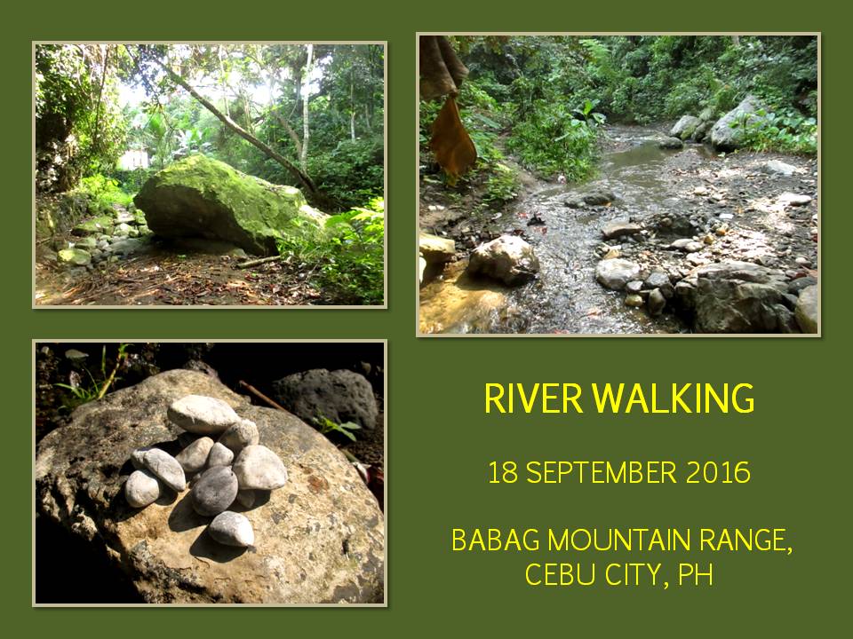
remind myself again that I am an ancient relic now and possesses no
more agility to leap over stones midstream. I go down a path before
the footbridge and walk along a bank of Sapangdaku Creek. The water
is robust and noisy for it had been raining a few days ago. There is
a bend up ahead and a big rock, ancient and covered in moss, faced
me. It had been there since it was swept downstream during
prehistoric floods.
Man-made
water holes, washing wells, fishtraps and footprints complement
boulders, sand, pebbles, vegetation, debris and deep pools in the
character of the stream. The sound of rippling water constantly hum
in your ears and sometimes disappears for a few seconds before it
emerges into a stronger resonance. All those times, my awareness are
at its edge, never wavering nor retracting into complacency.
The
water passes on a small channel where current is strong but crossing
the stream is easy here. I clamber over rocks when passage forward
becomes tricky. I have to be careful of where I place foot over the
other without neglecting other concerns like venomous reptiles and
harmful plants. It is always like that. Scan the places first high
and low before reaching out for a handhold or placing a foot. All
done methodically.
I
see few people on the stream. A farmer crossing a stream unaware of
my presence. Two women with a small child washing clothes by a bend.
Another woman with child doing the same chore on the mouth of a
small feeder stream. However, human presence are everywhere. Unseen
people talking and laughing nearby. A smoke flares up with somebody
tending it. Invisible children playing, their voices echoing on the
narrow confines of the stream. Someone feeding the squealing pigs.
Pebbles gathered by somebody and abandoned.
The
stream passes by a community and sewage pours into it. Stench is
revolting. Water looks sinister. Vegetation grows thick and fat on
the water channel. Few spots to walk and the only places are nearby
canal outlets. No choice except hold breath and make an exit quick.
At other times, it passes by thick vegetation where both sides were
linked by a bridge of vines that is so low, so dark and so
suspicious-looking.
When
I am on an open field, the stream looks so glorious in the morning
sunlight. It is as if I am in another world. Upstream becomes a
conduit of much cleaner water and enchanting scenery until the
channel is blocked by felled trees. The dried leaves and branches
cover everything what is below. Would I step on stone, water or
snake? I hope my feet touch dry ground always.
There
had been reports of Philippine king cobras (Local name: banakon)
escaping from a government-run zoo in nearby Kalunasan. When you are
a snake on the loose, the fastest way to travel is going downhill
and, when you reach a stream, you got all the food and the coolness
you need, and then work your way upstream. Aside that, there are
cobras in the wild also and this is still their habitat. I had not
seen one but I had seen other kinds of venomous and non-venomous
snakes.
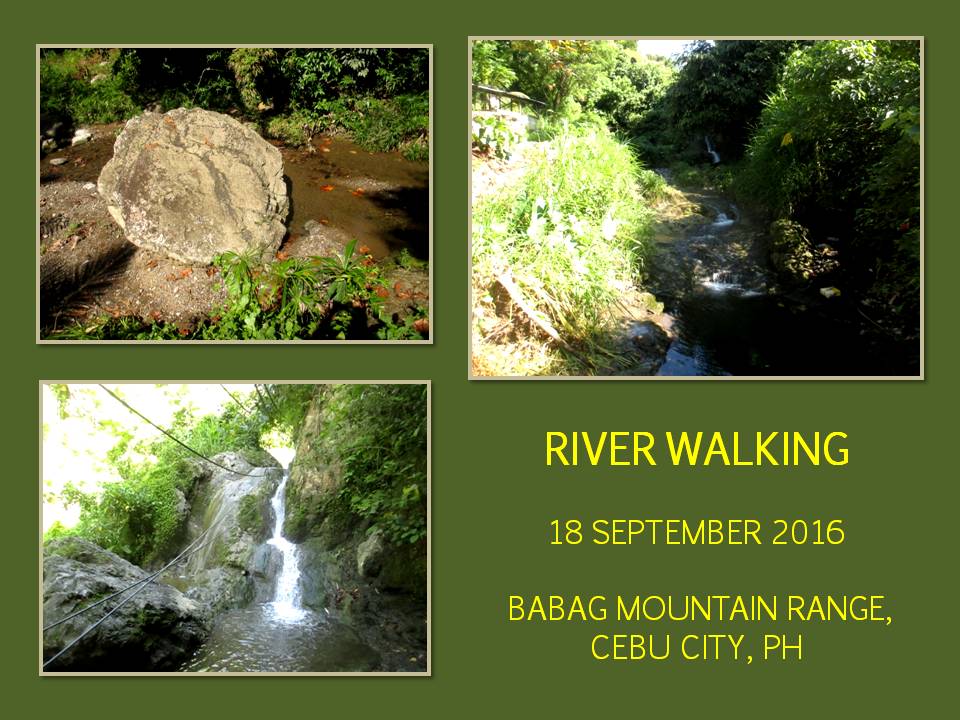
There
is that faint splashing sound that catches your attention which is
different from the usual ones made by a current ricocheting its way
on rocks and debris and shore. It grows stronger and stronger as you
approach and you discover it is a cascade, sometimes mistakenly
described by the many as a waterfall. A waterfall is a straight drop
of the stream from a height while a cascade is but a stream rambling
on solid rock from a height.
So
this is the one that caused so much racket everytime I walked the
trail above Sapangdaku Creek but I suspected it at first as a
waterfall. I do not have a name for this stream landmark nor I have
people to ask of. I have noticed that there are two pools created by
the drop. One on the bottom and the other on its middle. Besides
that, there is another separate pool on its side, created by an
overflow.
There
is a passage going to the top of the cascade but you would have to
climb a 15-foot wall of rock, which I did, thank God, I can still do
it at my age and bulk now. Scrambling rocks and boulders is no
stranger to me for I learned rock climbing in Cantabaco, Toledo City
in the ‘90s, back in the days when I was lean and strong and young
and fearless. But now, I am afraid of heights.
There
is another pool but narrow and above it is a chute on the rock that
channeled the stream at its swiftest current. This is a good spot to
take a bath since it is hidden. Maybe later. I walk upstream and
more of the wonderful features: pools, small cascades and
crystal-clear water with schools of guppy in it. Farther, there is a
trail built on a man-made pile of rocks. Motorcycles came down here
often as seen on the different wheel tracks. I just want to travel
along the stream.
There
is another deep pool, another set of big boulders and children. One
of the boys, who was crouching and unaware of my presence, dropped
his excess load into the swift current. The stream, like any other
streams in the Philippines, is a repository of everything, like
animal wastes, chemicals, garbage, sewage and excess loads. This
stream is polluted but people wash their clothes and dining utensils
and themselves with water from here.
I
am able to keep my shoes and my feet dry by my sheer wit in choosing
where I walk. In my experience, it is not wise to walk with wet
shoes unless you have no other choice. There was a time when people
were crossing Marbel River up to their crotch on their way to Mount
Apo, there I was leaping among boulders midstream over their
shoulders, not because I was showing off but because I am
uncomfortable with wet shoes and socks. That was dangerous! I was
able to accomplish that because I had a wonderful pair of shoes and I
was a fool.
The
clear water becomes white. Chemicals! I could hear a small engine
from afar. It is used to power a water compressor for spraying mango
trees. The sound gets louder as I approach and I heard another
sound, that of water being sprayed. Up on the branches of a mango
tree, a man is spraying the leaves and flowers. I held my breath and
made another quick exit. Cebu’s mango industry is the number one
pollutant of rivers! Next are the flower farms. Just look at the
abnormal growth of algae.
Once
upon a time, Cebu mangoes were the best in the Philippines and our
mangoes found its way to the US, Europe, Australia, Japan and other
countries. Not anymore. We are now overtaken by Guimaras. You know
why? They grow it organically while ours use chemicals. Food
standards are now high and very strict and, what was once Cebu’s
market, are now verboten. Sapangdaku Valley is mango country and
trees dot the landscape like broccoli. How I wished growers go back
to the basic and be less greedy.
There
is another deep pool and, above it, is a chute of water. I walk on
and there are sandbars. Two men are shoveling sand into empty cement
sacks. I walk past them and an abandoned spoon in sand. Another
small feeder stream joined Sapangdaku Creek. Passage quite tricky
but I saw a track of a person going upstream. Reading a track is a
skill. Most tracks are imprints on soft ground. That is the easy
part. Following someone on hard surfaces like stones and boulders is
extraordinary. I just love it.
Arrived
at a big pool with a good chute. The pool is dammed with stones to
make it deeper and to fence in fish. I go around it and am now in
familiar ground. Just 300 meters more upstream would be where those
crazies of Camp Red Bushcraft and Survival Guild would make their
dirt-time, if I am correct on my presumption. I walk past a natural
rectangular stone that could have been used by a local for sharpening
blades.
I
am at the spot of where they are supposed to cross the stream and
climb up a trail but I saw not one trace of them. Disappointed, I
drank my first gulp of water. I laughed at myself of why I went to
the great length of stealth-walking on a stream only to find that
they are not here. Well, it happens. Yes, it happened that I walked
that part of the Sapangdaku Creek where I have not had the
opportunity to do so. I am glad of my debacle. It was a great day.
Document
done in LibreOffice 5.2 Write
Posted by
PinoyApache
at
09:00
0
comments
Labels: Cebu City, commentary, exploration, reminiscing, Sapangdaku Creek, tracking
Friday, May 6, 2016
NAPO TO BABAG TALES 100: Wet and Wild
AFTER
MY YESTERDAY'S boo-boo, I finally got over it and go, once again, to
the parking lot of the Our Lady of Guadalupe Parish. Today, August
23, 2015, is real, for sure. The biology class of the University of
San Jose-Recoletos are coming over. According to their professor,
Ryan Ymbong, there will be twenty of them.
Unfortunately,
Ernie Salomon will not be with me. Another from the Camp Red
Bushcraft and Survival Guild – Nelson Tan – will take his place
but he will be late. Fine. For the past few days, weather patterns
are beginning to be predictable. Rain will pour hard during noon and
another sequel in the middle of the afternoon. Well, I am ready for
that but I am worried about my guests.
I
waited. Killed time by listening to the MP3 feature of my Cherry
Mobile U2 phone. A white passenger van arrived and out comes Prof.
Ryan, I presume, from the front seat. He instantly recognized my
khaki Silangan Predator Z backpack prominently placed on the concrete
pavement. My worries stretched into a frown as most of the students
are not wearing proper footwear.
That
would really be a problem when the ground turns muddy but, as long as
it does not rain this morning, that difficulty will not be much of a
problem. Anyway, I join the professor on the front seat and the
driver took us to the community of Napo. As we arrive, I immediately
gather them all and gave them a short briefing of the terrain and the
rough estimate of the distance to our destination.
Noticing
that some were carrying heavy things inside big plastic bags, I
requested these be equally distributed to others. I myself volunteer
to carry the heavy bunch of rice cooked in coconut-leaves (Local
name: puso) and the breakable items. At least, for now, the
load carried by hand would be tolerable and there would be no danger
of the plastic bags getting torn by blades of grass. Sturdy plastic
bags, I noticed, are beginning to disappear, replaced by those
brittle biodegradable ones.
We
start our activity with a prayer by Prof. Ryan. I lead but I walked
like someone who is strolling in Plaza Independencia under a pale
light of a full moon. Yeah, that slow. I believe (and I know) that
some pairs of feet would get skin blisters soon considering that I
saw bare skin above shoes indicating no socks at all. Oh well, what
a great way to learn plants and of hiking – later. That is why I
walk slow. I see a stinging nettle (daw-daw) and I begin my
own version of Plant 101.
I
am interested to learn more about plants since I teach people about
bushcraft. I have only a limited data of it right in my head learned
from the nuances of growing up, from books, from the mil and from my
late grandpa, who left me alone time and time again in a forest,
usually at dusk or at dawn, during his tireless journeys, mostly in
Bohol, while I was five and seven. I learned so many things from him
and what I learned I share.
I
may know some plants but it is limited to the local names, the
features and its uses. I do not have time for its scientific names
but, later on, through self-study, I begun to know its English
equivalent and, to a much difficult degree, their Latin conundrum.
Those that I have discovered recently, I turn to professional advice
in the Web but, mostly, site administrators are as stupid as I am and
so unaccommodating, leaving you more ignorant.
However,
perhaps, I may learn a thing or two from this bunch. Prof. Ryan had
read my blog and had requested me to guide them to a good site at the
Babag Mountain Range. I know places there where vegetation are thick
and would be a hoard of treasure to a biology student. It is where
streams pass and you do not need people to wreck havoc on their
bodies by leading them to difficult terrain.
When
you are into the business of wilderness guiding, improvisation
matters. It is different to mountain guiding where elevation,
adrenaline and scenery afforded by peaks are its main pursuits. I
had been guiding people for some time and I find the latter too
dangerous and too boring for my age. In the former, I found
fulfillment. It is that which people tend to appreciate your skills,
your knowledge and your time.
The
path is wet and parts of it are muddy which is bad enough. It will
get worse when rain comes falling. I change paths and follow the
trail going to Sapangdaku Creek. We follow it upstream until we are
on a level ground above the stream. This place is called Kangsi by
the locals and a lone family lived nearby. This would be a perfect
place as it had been previously in several activities that I
organized.
Prof.
Ryan began instructing his students, which are composed of the purely
BS Biology discipline and those of BS Education with major in Biology
Studies. They had with them their instruments in aid of their field
study like a GPS, thermometers, ropes, iron pegs, Petri dishes, glass
jars, cameras, pencils and journals. They are divided into four
groups.
The
area is divided into four quadrants and lengths of rope are unrolled
to delineate each quadrant from the other. I assisted each of the
four groups establish their own quadrants, especially the ones that
has the ropes go over the thickest vegetation. My big AJF Gahum
knife did a lot of work to clear a way for me to bring one end of a
rope to its farthest reach.
Three
of the quadrants cross streams while one covered steep ground. The
groups then collect their specimen, which are then documented after
several guessings of its taxonomic category, including the GPS
coordinates where each is found. Aside from plants, they also
gathered three kinds of grasshoppers, some crickets, a mosquito,
different butterflies and two varieties of fresh-water guppy.
The
rain came as expected, near noon, and all collecting activities stop
to concentrate instead to the preparation of their pre-cooked meals.
It is not safe to work on the streams for fear of flash floods.
Instead, I produce three banana leaves to cover the ground where the
food will be placed. The rice in the “puso” are many and
I could not believe I carried it all. Viands are the Tisa “siomai”
(Chinese meat rolls), “pancit guisado” (local noodles),
pieces of fried chicken and canned goods.
We
eat our lunch under the onslaught of rain. Fortunately, Nelson
arrived just in time to set up a tarpaulin sheet over where the food
is laid. To those who cannot be accommodated below the shelter, to
each his (or her) own to find some semblance of cover to justify a
human necessity of providing nutrition to self, like me. I have been
into this situation many times and it does not matter with today's
inconvenience.
There
is a lull in the sky and we were even afforded a glimpse of sunlight
yet I expect rain to come back with a vengeance later. The specimen
collection continues at 13:30 and everyone proceed to their assigned
quadrants. The stream had risen a bit and the current brisk.
Everyone pursue their work with wet clothes while I and Nelson stand
guard. I keep a special attention on the stream and on a shooting
suspect on the loose named Timoteo Gabasan.
By
14:15, the rains come back earlier than expected but it had stopped
after about thirty minutes. The students ignored the inconvenience
and concentrated on their field studies. At 15:30, the rains struck
once more, and again, at 16:15. When Prof. Ryan sees that his wards
have had enough of specimen collected, he called a cession to their
activity and everyone obliged and repacked all their equipment and
other things.
We
leave Kangsi (it rhymes like Camp Xi) at 16:30 under the cover of
incessant rain. The going was tough for those who wore rubber
flip-flops, ladies' sandals, espadrilles and all sort of improper
footwear, which almost were. They have to negotiate a slightly steep
path from river bank to the main trail which looked like a crude
imitation of a water slide and the main trail itself has pools of
water along some stretches where there are depressions.
Prof.
Ryan was exhausted after the hike back to Napo and he was the last
one to arrive. Their transport have arrived earlier and waited until
such time that everyone were accounted for. I take my usual place on
the passenger van where I got dropped off at Guadalupe. Nelson,
meanwhile, took his motorcycle and was already gone when I arrived.
I would part Nelson his share of the fee when we meet next time.
Anyway,
I accept people who requests of my services in guiding them to the
mountains but, mostly, I refer it to my subalterns if it is for
leisure hikes only. I would personally engage if the purpose is of a
higher calling like today. I used to be a freelance mountain guide
many years ago and I find no satisfaction in that because it demands
technical skills and the risks are great with which compensation does
not tally well with your efforts and the gears you invested.
As
a wilderness guide, the risks are not that great and does not demand
expensive gears. You have to have a different set of skills quite
different from those activities done at higher elevations and is much
in demand and, therefore, a bit expensive than usual. Guiding an
archeological or a scientific expedition is one such example where
the professional wilderness guide should be extraordinary and possess
a high-level of expertise and ability.
Whenever
you have such need of a guide for a planned Philippine expedition
project, I can be contacted and be hired directly through my mobile
numbers at +639172035101 and +639333225005 or you may email me at
pinoyapache (at) yahoo (dot) com. If you so desire to see my
credentials, I can attach it in my email in PDF or JPEG, whichever
you prefer.
Document
done in LibreOffice 4.3 Writer

Posted by
PinoyApache
at
09:00
0
comments
Labels: guiding services, plant ID, Sapangdaku Creek
Subscribe to:
Posts (Atom)