
WE
KEEP THIS ACTIVITY a hush-hush so we contacted just a few
individuals. Jhurds Neo, Dominik Sepe, Ernie Salomon, Boy Olmedo and
a rough cut, Mark Lepon, came today, September 7, 2014, at the
parking lot of the Our Lady of Guadalupe Parish. When we had secured
the ingredients for our noontime meal, we left Guadalupe at 07:00,
taking the route to “heartbreak ridge”.
It
is a warm early morning and I begin to feel the heat by the time I
hit Bebut’s Trail. My legs begins to work as my lungs suck in air
as the terrain inclined. It is a cloudless day but I do not discount
rain. It would probably come late in the day or early evening. I
walk in a hastened pace, a pace that is forced upon me by the
bareness of the ridge. A slight breeze gave me slight comfort but I
need shade which you could indulge only behind this long hill which
could be reached at the top.
By
the time I reach a steel tower, I just stop to take a selfie and then
go on my way to the top. I reach the tunnel vent and I looked behind
and saw Boy walking past the tower. The rest are struggling behind
him. Yonder me are bushes and farms and a few stunted trees. Beyond
that are tall trees and thick vegetation. I reach the periphery of a
farm and there is shade. I take my first drink of water but I
inadvertently swallowed it instead of taking a small sip.

I
waited for the rest near an abandoned hut and noted the minutes. I
saw a wild basil plant (Local: sangig) and I cut off a branch,
intending to add this as another ingredient for our meal. Boy
arrived three minutes after me and he is winded. The group of
Jhurds, Ernie, Dominik and Mark arrived seven minutes later. I see
Jhurds and Mark suffering from the exertion of walking up the ridge.
That is why I call it “heartbreak” because it had broke the
hearts of many individuals.
I
have led people here and I could count seven people giving up without
mentioning their names. Likewise, another five were on the verge of
collapse but have recovered to reach the top and finished the
journey. As I was recollecting that, I sharpened a short stick with
my AJF Gahum heavy-duty knife and throw it like a knife to a
trunk of a banana at a distance of three meters but I missed the
target. The stick pierced instead a papaya leaf behind the banana.
We
proceed with our journey. Tree cover is good and I relish at the
shade and the sounds of different birds. Soon we will reach the
Portal. I notice many trail signs which I gave close attention to by
stooping to get different angles of view or to touch the texture of
leaves and stones. I would have explained my actions should one
behind me asked what I was doing but all were only concerned of their
own dispositions, unable to go beyond what they perceived.

Moments
like these are the best time to learn nature. You just have to shed
off your conventional nature learned in university classrooms and
corporate environments and become entwined with Mother Earth. You
have to change your mindset so you could adapt quickly and understand
more about mountains, trees, wildlife, birds, streams, even the
thread of ants that cross the trail. All of this tell their own
story.
I
reach a high point on a trail and take rest near a grove of spiny
bamboos (kagingkingon). I noticed that the trail had recently
been given a good “makeup”. It is widened. The grass and brush
on both sides had been sheared but this is a route that only few
people use and nothing special. There is, however, a scheduled foot
race that will use this route. Not a good idea. We proceed on after
foraging sand bamboo poles (bagakay) left by a local on the
ground. I think I may need this to where we are going.
We
did reach the Portal but we only pass it and continue on to another
trail which goes on toward the road at Baksan. The promise of rest
only tempt me to drink more water than I should normally take. I
broke my simple rule on water discipline a while ago and now I am
beginning to feel the backlash. The concrete road had recently been
cleared of debris and soil brought by excessive rain the past few
days. We will only follow this road for a few meters before burying
ourselves again into the forest.
I
gladly transfer into another trail, dipping into a forest of Burmese
teak where Lensa Trail treads. The trail had been parted wide by
great volumes of water during heavy rains. The path took us to high
ground and veered right to another path that follow a low ridge which
goes to a saddle and onto another ridge which steadily climb up a
hill, which I tagged as Boy T’s Hell. We take a short rest while I
take another swig from my bottle. From there we follow a path
blocked by several fallen trees until I found my trail sign.
I
have created a path here for the 2013 edition of the Philippine
Independence Bushcraft Camp and this path had stayed. The vegetation
changed as we go down a stream which I named as Creek Alpha, for want
of a name. The air is humid but cool. The stream is brisk and full.
I step on stones so I would not leave footprints on sand and on the
banks. Dominik saw animal droppings on sand and, instantly, I
recognize those as belonging to a Malayan palm civet (maral).

We
move on from the stream into the rest of the trail. I thought I
heard the sound of flapping wings associated with birds being
surprised but it stopped abruptly instead, the rest of its sound,
like that of a long burst of its flight, totally missing. How
strange? Then I heard something falling on the ground. Might be a
broken branch. The first sound is heard again and, a moment, a thing
falling. Slingshots!
People
with slingshots on higher ground, unseen from view, had been shooting
at an unknown target among trees, the trajectory of their pebbles
arching down towards me and my companions. I shout at them of our
presence and it stopped. A dog barked. We hurriedly left the place
and wind into a lot of bending paths with lush vegetation. A lot of
recent trail signs are left by locals and by a canine.
We
reach the second stream, which I named as Creek Bravo. This stream
seldom has running water but today it is singing its heart out
because it is full. Jhurds had been asking for coffee but I suggest
we have it at Camp Damazo instead, where we will also have our lunch
later. It is now 09:40. Camp Damazo hosted the PIBC 2011, 2012 and
2013 here except this year to give way to the coffee seedlings
planted there. We will go there today because the place is special.
We
climbed up a low ridge where there is a beautiful path. I saw a
mummified human dropping, a month old, smacking right on the middle
of a big dried leaf as I ascend on the last few meters. The absence
of flies indicate that it had exhausted all its organic odor unless
you deliberately step on it. Everyone gave it a wide berth but
rattan tendrils abound here. It grabs your shirt, bag and skin just
like it did to my Silangan hike pants.
I
drank water again and I notice the bottle beginning to go light and
noisy when shaken. I could not believe it that I “waste” a lot
of water. I see a lot of debris and felled branches but I am only
interested with dry firewood, which I would forage up ahead. Most of
the coffee seedlings planted are not healthy despite being maintained
by a group of farmers. I believed the ground is just too dense and
too rocky with a fully-grown forest to compete with ground water and
sunlight.
I
reach Camp Damazo with an armful of firewood and I see the middle of
the fire ring planted now with a single young coffee. The place is
shrouded with a vapor-like mist or could it be a remnant of a very
early morning smoke? I just cannot give up this place for it is a
perfect campsite with water sources not far away. Thinking of water,
I drank generously my diminishing supply knowing I could have my
bottle refilled later. I sat exhausted on a root of a Moluccan
ironwood tree (ipil) waiting for the rest.
Boy
came first, then Jhurds with another armful of firewood and then
Ernie, Dom and Mark. All open-carried a knife except Boy. The
knives are then used to break and split firewood. Ernie used his
Mora knife to slice vegetables and meat as he begins to work
on our meal. Two AJF Trivets are set up to stabilize pots
above a fledgling flame. I retrieved my foraged basil leaf and gave
the leaves to Ernie while I plant the stalk on a spot where water
would accumulate should it rain.
Within
the camp is a debris shelter which is less than a day old. It is
made of zingiber stalks and leaves, which are abundant in the Buhisan
Watershed Area. The inside is spacious and can accommodate three
sitting people. Hot coffee are now distributed. Coffee, oh coffee.
It always tastes good in the outdoors, even on a hot day, especially
for someone who is thirsty and tired.
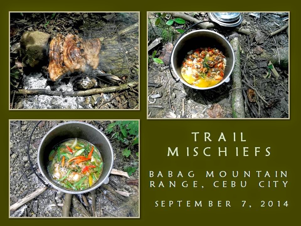
Jhurds
had always been generous when it comes to food. Today, he brought
raw blood clams (litob) and marinated pork. Ernie knows how
to cook the clams in his own special way while Dominik will take care
of the pork. A second fire is started by Dom where an iron grille is
placed above it. Mark and Boy helped Ernie with the vegetables as I
begin to search the camp for a spot to make a boar trap.
Laying
a trap is without purpose if you cannot lure prey into it. A few
good reasons why a boar will approach a place near where your trap
is, are food, water or the opportunity to find a mate. Absence of
all will make your trap useless unless you drive a boar to flight.
When it runs it always follow a path of least resistance, like a
trail, and would use the slope to hasten its escape. Man smell will
prevent a boar from approaching your lure or it may stimulate its
flight.
The
trap should make it appear that it follows the trail, then diverted
to a different path by blocking it with a very gentle arc of
obstacles towards the hole. The boar, when stressed by pursuers,
would follow that diverted route and into the trap. I have seen a
perfect place (and the route) where a boar would be lured to run.
This will start from Creek Charlie, follow the trail to Camp Damazo,
then diverted downhill to a narrow ridge. Side trails should be
blocked. Water of the stream and some wild yams (bulot) could
provide impetus why a boar should follow your plan.
Unfortunately,
the small ridge I choose does not allow me to create a hole large
enough to accommodate a boar for the ground is dense and rocky.
Although I have bamboo stakes, leaves, twigs and things nature could
provide to make a boar trap, I do not have modern tools to make such
a hole on a hard-packed ground. And I do not have the luxury of
time. Making a boar trap is labor intensive and can be done in two
to five days! I may have to make an alternative instead. Why not
make a deadfall?

I
go back to the campsite. Jhurds is squeezing the juice out of a
grated coconut and would be mixed with a vegetable soup that Ernie is
starting to finish. Dom had done with the first side of the pork and
now had just flipped the other side facing the embers. I went past
them, going to the rest of the camp. As I was walking, I noticed a
flat ground below the trail I am on. I looked for a path and found
it near a debris shelter that we found earlier.
Slowly,
I tread among bushes, palms, zingibers and thick vines and come upon
an almost flat ground. There is an abandoned makeshift shelter where
there is a stock of firewood, a plastic gallon of water and empty
flat bottles. The awning is made of abaca leaves, now frayed,
supported by sticks laid horizontally that are propped by forked wood
dug on the ground. This piece of flat ground could support five
shelters but it is best with hammocks.
Walking
back, I saw another bigger ground blocked from view by thick vines
and zingibers. I have ascertained that it could accommodate seven
shelters and more with hammocks. I begun to entertain in my mind
that Camp Damazo could again host more PIBCs in the future. Besides
that, this one is hidden from view if local people pass by because it
is very secluded. Perhaps also, this one is nearer to Creek Charlie.
I
return to the campfire and I see the pot of rice being cooked.
Jhurds and Mark volunteered to fill our empty bottles with water to a
natural spring. I decide to look for a tree that might had been cut
by a local. I found one on a steep terrain just below the trail that
we had passed more than an hour ago. I go down to pull the dead tree
but it is heavy. I decide to separate the lower trunk by chopping it
from the rest. I dragged it to the trail and it would do as a
deadfall, it being about four feet long.
Exhausted,
I go back to the group to drink water. Fortunately, my bottle is
full as it was filled at a natural spring by Jhurds and Mark.
Dominik had already sliced into bite sizes the last of the grilled
pork. The rice is transferred to an abaca leaf to make it easy for
all to reach and take refills. Lunch begins. I fished the blood
clam first and ate it, then I take a refill of rice and poured the
mixed-vegetable soup into it and eat contentedly. Another refill of
rice, I paired it with grilled pork. It was another feast for Camp
Red.
After
I had eaten lunch, I immediately go back to the place where I left
the trunk. Jhurds and Mark came with me to observe and, later, to
help me set up the deadfall. I carried a coil of nylon rope and a
plastic bag of cords. I make a notch on one end of the trunk so rope
would not slip when I tie and suspend it high while Mark lent another
length of nylon rope to reach the high branches.
The
deadfall is placed above the trail and would swing towards an
intended target once it is released by a system of spring mechanisms
and triggering devices initiated by the target. The trigger cord is
placed on the trail where it would be accurately stepped on by the
right foot. I demonstrated its efficacy upon a wooden dummy and the
deadfall barreled it away, scattering it six feet from where it was
placed.
Sharpened
wooden stakes buried on the trunk would make it more deadly. Not
only that, the action of the swinging trunk would also open up many
possibilities like activating peripheral “offensive” systems
which would chuck several targets after the first one. It was very
tempting to set this all up but, again, I do not have the luxury of
time. I decide we go back to the campsite since it is almost 16:00.
After disposing our garbage and packing up our things, we put out the
fire thoroughly and leave.
We
pass by the natural spring and two streams before climbing out of the
jungle towards Baksan Road. Ernie suggested that we take the road
instead going to the spillway at Sapangdaku. It was a tiring walk
although it was downhill but a concrete pavement is never kind to the
feet. We arrive exhausted at 18:00 at Guadalupe where Jhurds and Boy
left immediately. As predicted, rain fell that early evening and I
have to wait out the storm with bottles of cold beer that Boy Toledo
had provided free for me, Dominik, Ernie and Mark.
Document
done in LibreOffice 3.3 Writer








