Showing posts with label Tagaytay Trail. Show all posts

Wednesday, July 15, 2015

NAPO TO BABAG TALES LXXXVI: Real-World Education

IN THE COURSE OF MY outdoor activities, it cannot be denied that people would ask and wish they could join me. I am very gracious when it comes to that but I cannot accommodate all since I find most of my weekend time focused on the development of the Camp Red Bushcraft and Survival Guild. Another reason is that I am a bit choosy now of the kind of people I welcome.

I would be very happy to bring people to the seldom-known places that I frequent but, at the same time, I have second thoughts. The main cause for that is these people I bring are bound to abuse this privilege. I would always assume that everyone understood fully about the Leave No Trace principles, especially those that professed to be “mountaineers”, but, on the contrary, they use their “new discovery” as an opportunity to promote themselves and gain a profit from the very people they invite. The more people coming, the better the profit, is it not?

Wrong! The more people coming, the more you get to disturb these pristine places and the higher the chances of accidents. People would only follow LNT when somebody is watching and when there is a profit to gain they do not care. That is why I found LNT amusing and cumbersome since the very people who are supposed to promote it, even to the extent of quarrelling and threatening other people over it, are the ones who are likely bound to discard it.

LNT is taken advantaged of by the outdoors-gear industry and the people that thrive in it like travel agencies and income-driven individuals that they used the logo as part of their corporate symbol and a tool to gain profits. I do not follow LNT because I found it shameful to be associated with these people but I respect its intent and I believe it will give the uninitiated the proper knowledge and guidance when in the outdoors and on their everyday life.

Let me remind all that you cannot, and never could, impose LNT on everyone and that includes me. If you think it is a rule, suit yourself, for you are only exposing your ignorance and naivete. Do not worry. For the many times that I have been invited in a mainstream activity, I would always show courtesy to the crowd and blend in with the activity as if I know my LNT well. That is flexibility for you. I hope you have it also.

On the other hand, I would always inform people that had been fortunate enough to tag along with me about my methods else they might find it revolting. I do not want to give an impression that what I do is conventional and ordinary like everyone is doing. When you are with me, you will act like real outdoorsmen. You will appreciate silence and nature to the very core. You will learn a lot aside from doing all your “jump shots”.

That is what is happening today, November 30, 2014, when I answered a request by four guys who worked in a business process outsourcing company to join me. They name their informal group as Takoy Outdoor Club and one member looks familiar. He looks like my eldest son. Anyway, I demand that we should leave by 06:30, which we did. I place great emphasis on punctuality from hereon and I do not want somebody derailing my itinerary again.


We hit the trail once I gave them an on-site briefing at Napo. Our route is the “Rosary Loop” which consists of the Napo Main Trail, Manggapares Trail, Liboron Trail, Babag Ridge Trail and the East Ridge Pass. It had been raining for the past two days and two nights and the ground is wet and muddy. Today, it had not, although, I expect heavy rains caused by an approaching weather disturbance.

Running parallel to our activity is a patented dirt time by members of Camp Red. They will be passing the same Manggapares Trail later. However, they would start at 10:00. I found the trail undisturbed yet by footprints made by yuppies. The sky is gloomy with a high chance of precipitation. I inform everyone the proper name of the river below the trail. It is important that correct names of places be known to everyone so you would not look stupid by giving it another name in Facebook which a lot of people unintentionally do.

We reach the trailhead to Tagaytay Ridge at 07:10. I told everyone that we are too fast. We may suffer for that when the terrain becomes steep since we did not stretch our muscles prior to walking. It could be muscle cramps, overfatigue or loss of body heat. It is important that they know this. Now they understand why you have to control your pace. The path to Manggapares is thick with weeds and I regret I did not open carry my AJF Gahum heavy-duty knife yet.

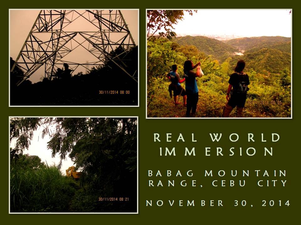
It is 07:30 when we we arrive at the first steel pylon. I take the time of rest by retrieving the AJF Gahum from my Silangan Predator Z tri-zip sack. I talk about the history of this trail and how I re-discovered it. I could see the adrenaline of the four beginning to show for the reason that they had been yearning to explore for themselves of this place which they only heard as the “Six Towers Trail”. They are now on the threshold of it and they will not regret their luck today for they will see and learn more.

Going to the second tower, I show them an edible snail. This is a snail that lives on trees and it is abundant here. We push on down to a saddle, cleared some vegetation with the knife, and up again until we arrive at 07:50. The guys are exhausted but desiring for more. We did not tarry and proceed to the third one, which we reach at 08:00. Along the way, I showed them fruit trees which are free for picking like I did with a pomelo (Sp. Hystrix grandis). The view from up here is just too stunning for the four. They are now smiling.

They begin to appreciate the beautiful trail that lead to the fourth tower. We reach it at 08:15 and I inform them that we are now walking on a dirt road. They are confused since they only see a trail but, up ahead, they saw an abandoned payloader. They are now beginning to make sense in everything I talked about. The fifth pylon is easy to reach and we got underneath it at 08:25. They are now staring at the sixth.


I shift to another trail and the sixth power pylon faded from view. I am onto a path that is very difficult as it is very challenging which make passage of the sixth tower unnecessary. This is the Liboron Trail and it had returned to a condition when I first walked here. Rains caused the softening of the ground and my footing slip time and time again despite my effort not to ruin the path. It was for this reason that I insist that everybody should wear shoes.

I point to the place where I fell six meters and everyone are now very careful. After that very tiring walk, we rest at a saddle and enjoying the chance to drink water. I teach them water discipline since they swallow a lot of water. When we think it is alright to proceed, we shoulder our bags and walk up a hill. I tell them the story of my encounter with a grass owl as we pass by a field of cogon grass.

We go down into another saddle where bamboo poles fell during the recent typhoon called “Queenie” and blocked the path. I crawled underneath and the rest followed. A barbed-wire fence is another obstacle that we have to go over. Fortunately, a path had been cleared between it and another grove of spiny bamboo. I pass by between it but I advised the rest to watch out for the spines which might catch their eyes.

We walk on, crossing a small brook and climb another hill where the Caburnay homestead is located. Barking dogs greeted our arrival as Julian Caburnay welcomed me and my companions. I showed the guys the water source and I begin to boil water for coffee with a butane stove. Leaving that, I went out of the homestead to gather dry firewood and kindling. It is hard to find dry wood but I am able to bring back partly-moist small branches, old banana leaves and cloth-like coconut fibers called “guinit”.

I drink my share of the coffee. I found a cord from my bag and begin to make a tripod where the cook pot will be hanged over a fire. Once done, I cut a whole leaf from a giant taro and laid it on the wet ground. I break the small branches and arrange it over the leaf. With my William Rodgers Bushcraft knife, I shave some wood and made several feather sticks. I remove bark from the bigger wood and split it so it could air out moisture.

I crumple the guinit and the leaves into a tight bunch and rub it with my hands until it begins to break in small pieces as friction warmed it a bit. I place the kindling above the fire nest. I retrieve a black hair-like kindling from my fire kit and place it underneath the nest. I struck a single match and the material caught the flame and it spread rapidly. Thick smoke begins to show from the coconut-and-banana material as heat begins to wick it of moisture.

Everyone watched of how I prepared the fireplace in such a different way from what they had known; of the careful way of how I made the firewood and the kindling ready prior to the introduction of fire. When fingers of flame begins to consume the smaller wood, I place more twigs over it and I start to measure rice into a pot and then pour water. I hang the pot over the fire, adjusting the tripod so the bottom of the pot touches the fire. They watch and feed the fire while I get busy with the pork meat.


Julian gave us ripe bananas to munch on. It is organically grown and it is very sweet. Meanwhile, the guys look over the dragonfruit plant and the different ornamental plants that Julian had been growing here. The sky remained gloomy and it is our lucky day that it had not rained. When the rice got cooked, I hanged another pot over the fire. I pour cooking oil then saute crushed garlic and sliced onions. Later, I added sliced green pepper to the fray and finally the meat. I pour soy sauce and waited for it to boil.

As we were in the middle of the cooking, a lone hawk whistled. It circled above us. We continue our cooking when it disappeared from view. I let one of the guys improve the taste with just salt and then I add basil to enhance aroma. Now, time to enjoy that well-deserved meal served hot in a real boodle-fight location. The food was wiped out clean from the banana leaves and just a few morsels for the dog. However, I made it sure that Julian has a fair share, including uncooked rice and canned goods I brought specially for him.

Before saying goodbye to Julian, I show the guys how a basil herb looks like. Beside the basil, is a miniature guava tree with small fruits. They were just amazed at these discoveries and hoped to come back again. I brief them again of the remainder of our journey. We walk up to a ridge and the guys gets a good view of the wide landscape again. The trail now is thick with vegetation so I let the knife work – again.

Branches fell during the typhoon and it littered the trail as well. It is hard work but I love it. The knife cuts efficiently and, when there is nothing to cut, I return it to the sheath; then I start again and again until I reach the Babag Ridge Trail. I let them know that this is an old trail that I had used as training ground in the early ‘90s. It is a trail I lose track of when I laid low from climbing mountains and re-discovered it just more than a year ago.

They were all amazed at the wrist-thick rattan trunks that cross the trail. I also let them know that this trail is frequently used by off-road Enduro riders on weekends. Up ahead the trail would be fenced and we would make a long detour. Property owners had blocked access to motorcycles but these had not stopped. Some trees had fell, blocking the path, but we manage to go over it. I scan the upper part of the forest to see if there are hazards above.

We pass by the place where there is a cave. The path going there had been destroyed by the typhoon and we were not able to climb up to that higher ridge. So, I just told them that it was used by the Japanese as a defensive camp during World War II. We walk on and pass by a tunnel entrance that was blocked by logs. I told them that this is just one of many that the Japanese had constructed. I pointed to them the place that I referred to as the “last wild place”. I pick up a broken branch and remove Spanish moss. Future tinder.

We stop at a saddle and, there, the guys fell in love with the view of the Bonbon River Valley. This vantage do mesmerize a lot of people for it expands their adventurous spirits when gazing at the far wide-open spaces. One of them asked if I leave trailsigns. Good timing of question. I do not frequently leave signs unless it is for a last resort. I showed them my only trailsign on this whole route which, coincidentally, is located just a few meters away.

The route passed by along fences down into a dry brook and up into a different ridge, crossing it, down into a saddle and up to the Babag Ridge. Winded, we rest on a bench. A dirt road leads to the “tower area” where the highest peak- Mount Babag (752 meters) – is located. There is a trail going down - the East Ridge Pass - which lead to the Roble homestead, which we reach at 14:00. The guys are happy to get a respite from that downhill knee killer


After drinking green coconut water, the guys climbed the tree house and took rest there while I take time to talk with Fele and Tonia Roble. The children Manwel, Juliet and Josel are here too. They cook wild sweet potato for me and I munch on it. I will bring some for home and this is the kind that my wife loves best. We leave the Roble family at 15:00 for Sapangdaku Creek. We reach the stream and walk back to Napo. I notice six sets of shoe prints, to include a female, and it had already disintegrated due to contamination of other footprints made by locals.

We ride motorcycles-for-hire at Napo for Guadalupe. We transfer to the new watering hole, the Bikeyard Cafe. It is still 16:00. We had walked fast and one of my knees suffered. It is numb. But we are on safe ground now with plenty of cold bottles of beer on a bucket full of ice to curb dehydration. I just taught real-world education to these guys which they cannot find in LNT-laced activities.


Document done in LibreOffice 3.3 Writer


Thursday, May 16, 2013

NAPO TO BABAG TALES LIX: Reunion With an Old Trail

I NEED TO KEEP FIT before I will embark Segment III of the Cebu Highlands Trail Project come May. There is a new route within the Babag Mountain Range which I have discovered last January and would be adequate to fulfill as a training ground and I may have to do some exploring to reach a ridge which was denied to me that time.

So, on March 17, 2013, I went to Guadalupe Church to wait for Ernie Salomon and a couple of guys for this but only Ernie is present and, later, Mr. Bogs. Eli Bryn Tambiga appeared with five others. They were supposed to climb Mount Babag but Eli Bryn thinks he could bring satisfaction to his group by joining us.


After securing our food provisions, we leave for Napo at 8:10 AM. We cross Sapangdaku Creek and walk the trail towards the trailhead for this new route. Last time, I descend from Bocawe but, this time, I will do the reverse under the heat of summer. This trail goes up to Tagaytay which is a long ridge. A beautiful trail is found on its back but, sadly, a dirt road has been opened to accommodate heavy equipment for a series of power pylons under construction.

I do not know the physical condition of Eli Bryn’s guests, especially the three women, but I am consoled, by the fact, that all are registered nurses volunteering with the local chapter of the Philippine National Red Cross. My main concern is drinking water for the group and there is no water source here except at the place of Julio Caburnay three kilometers away with which place we will prepare, cook and eat our lunch.

I go slow when one of the nurses almost fainted. I need to use available shades in between as resting places. The length of stay would depend on the distance between shaded areas. The ridge is not populated and there are no houses but there are mango, jackfruit, soursop, pomelo, tamarind and lime trees. A lot of these bear ripe fruit but we only take lime and a couple of pomelo.


The sun deliver its brunt along the bare places where the dirt road start. A bulldozer is parked precariously along the edge of a big hole. Although it provide a little shade, I advise my people to stay away from it else ground underneath it had lost its integrity and might collapse due to weight. Rays of the sun bounced off the dirt road and the rests are longer.

We found an open shed for the absent construction workers and I decide we make coffee to pep up our sagging spirit. The cool bamboo flooring is a welcome respite and I come to know better the rest of the party. Two of them are recent participants of an international offroad triathlon in Liloan and that is why they have been unaffected. Nearby is Liboron Trail that I used last time but I remove that idea as it is quite dangerous for inexperienced hikers.


After the coffee break we need to overcome the last rise instead and see what is on the other side. We reach it in about five minutes and Eli Bryn take a reading from his altimeter at 600 meters. The dirt road wind its way down and join the Bocawe-Cabatbatan Road but following it meant that I have to say goodbye to an exploration. Across me is a high peak and looks formidable in the middle of the day. I heave a sigh of good relief in finding no trail going up. Good riddance!

I found a path at the right and it goes down, maybe, to that dangerous trail which does not endear well to me at this time. I may have to find another route that would go around this peak so I follow the edge of a small gully and I found a rarely used trail which is now covered with grass. It goes around the hill and out into a wide meadow. The path disappears but I can understand now the gist of the path’s direction as it goes straight into a barbed-wire fence.

I squeeze into and in between the loose strands of the fence and I am on the other side. Meanwhile, the others wait until I give them a signal to come over. The other side of the fence is thickly wooded with dense underbrush. My senses peak up to watch out for snakes and toxic plants. This is is what I loved most – to read signs among thick bushes and recover long-lost trails. I wind among vegetation and intentionally step on the trunk of a small stinging tree to keep it out of the way.


The ghost trail goes down into another meadow and another low hill stare across me. I saw a small saddle on the right and I walk towards it for I know saddles are natural passes. When I’m done, I see the part of Liboron Trail where it is not yet dangerous to tread and go the other way towards Julio’s place which we reach at 12:00 noon. Everyone needs a full drink of water, some shade, hot food and a good rest.

I softly retire after I have prepared and cooked milled corn. Ernie take over and dispatch all food ingredients under his multi-tool knife. Others help in the slicing of spices and vegetables as I just listen to their conversations not far away with closed eyes and unknowingly invite an unwelcome company of pesky black ants that make my nap a come-and-go affair.

A spoon is rapped on a cup signalling that food is cooked and ready for the taking. I glance at my watch and it is 1:45 PM so I look for my stainless steel cup and wooden spoon. Food cooked are chicken sinigang, garbanzo beans and “shrimp paste special”. Ernie prepared a dessert of raw cucumber and tomato. I prefer just chicken soup with two refills before adding milled corn for my third refill and some slices of cucumber.


Feeling rejuvenated, I need to leave for Babag Ridge in the quickest time possible as we have a few daylight hours left. Julio’s nephew give me directions to reach the ridge by an ascending trail. We leave at 2:30 PM and the heat of the day is not felt here as cool breeze from the sea are abundant at the higher level. I reach the edge of this trail and it connect to another, much older, trail on the top of the ridge itself. The altimeter said that we are now at 700 meters.

But there is something familiar with this trail. I try to reorient my memory with this trail and I begin to realize that this is the same trail that I used as a training ground in 1993 and 1994. I would start solo then from Buhisan with a fully weighted Habagat Venado II and walk the whole day toward Upper Busay. Later, I did trail running here. This is the same trail that I had been looking for a long time when I returned hiking in 2008 after I have stopped climbing mountains in the late ‘90s.

It is like a homecoming. A reunion. The trail have now become wild as was the last time I saw it. Vegetation have claimed the spaces and I have never seen rattan palm trunks as thick as a man’s arm growing here. Back then it was wider, wide enough for a mountain bike to pass but this is better this way. I would rather have shoe prints leaving mark on this ground than the rut of wheels.

I follow the trail to Mt. Babag and I see the familiar view on the other side of the mountain range that you don’t normally see approaching from Napo. I have a good vantage point of the wide Bonbon River Valley from here and, across, are Sinsin Ridge and the Central Cebu Mountain Range. Rising north of Bonbon are the twin peaks of Mount Pung-ol and Mount Sibugay, the latter being erroneously referred to as either “Sirao Peak” or “Mount Kang-irag”.


Too many fences along this ridge have disoriented me no end and leave me fatigued in mind and body, especially when finding a route. Because of these fences some parts of the original trail have vanished or were diverted and becomes unfamiliar to me. This is aggravated by, the fact, that there are no water sources here. We reach the shoulder of Mt. Babag at 4:00 PM and make no time for rest as our urge for water plunge us to reach the Upper Kahugan Spring.

When I reach the watering spot, the piping system had been dislodged and the spring water from the ground is exposed to foreign matter and so I skip it hoping to obtain drinking water at the Roble homestead instead. I meet six climbers along the East Ridge Pass and they are going to Babag Ridge until I reach the house at 4:45 PM. I wait for the others to come but it would be a while because the trail is bleached hot by the sun and the soil is loose making descent quite a trouble.

When all have arrived, we said goodbye to the Roble family and leave at 5:30 PM for Napo by way of Kahugan Trail. Nightfall overtake me at Lower Kahugan Spring and one of the female nurses is having trouble walking so I lend her my LED torch to aid her. I follow her until I reach Napo at almost 7:00 PM. I wait for the others and dispatch them all back to Guadalupe before I leave myself.

It was a perfect day of toiling and training to make myself fit. It was originally a solo affair but I decide to include all comers. All are safe, did not suffer injuries and are satisfied of being at places in a series of “firsts”. Lastly, I have finally found my old trail which I thought had been converted into another road. It still exists and is untamed. Now I know the mountain range much better now.


Document done in LibreOffice 3.3 Writer


Sunday, March 3, 2013

NAPO TO BABAG TALES LVII: The Last Wild Place

THERE IS A PLACE on the Babag Mountain Range that have been tingling at the back of my mind for some time ever since I have known of its existence in 2009 through Feleciano Roble. Then on Freedom Climb 2010, I happen to meet five people with hunting rifles along a trail and they were heading to that place. I was totally envious of them.

I have been egging myself to explore that place but each time I entertain thoughts of that it simply gets buried below by my other priorities. I have a day job and I have only three Sundays each month for my family and for my outdoor sorties and lectures which I usually do with the Camp Red Bushcraft and Survival Guild.


That place is simply hidden from your usual view of the landscape if you happen to walk the Napo Trail, the Kahugan Trail, the Babag East Ridge Pass or even from the Babag Ridge itself. Few people go there, even among locals, and it is a wild place, perhaps, the last wild place of the Babag Mountain Range. I will need to be there before it disappears from illegal logging and bush fires.

On January 13, 2012, I decide that this will be the day of visit. I do not know the route in going there but I know it is south of Kahugan. I will have to ask from the residents and, once done, my trail sense would make the best out of everything. Physically, I am out of shape, a condition that have been dictated by the bounties of December parties, but I am fit to meet the challenge.

Tagging along is Ernie Salomon. He have longed to visit this place when he knew also of its existence and he had been pelting me with repetitive questions of when would I decide to explore this place. Today, I will not deny him that chance and he will later do the cooking while I do the thinking once I face the obstacles.

All hikes going to Mount Babag has its place of start at the Our Lady of Guadalupe Parish. On Sundays, when parishioners stream out of the church it is such a colorful and delightful sight. Outside of the church grounds is a streetside market where uplanders sell their vegetables and fruits to the urban dwellers. At the back are small eateries and family businesses that sell grains and day-to-day needs.


I buy a kilo of milled corn to add to my backpack weight which already is crowded with an Apexus tarpaulin sheet, a 25-foot flat rope, cords, extra shirt, my fire kit, tomahawk, machete, extra shirt, camp stove, isobutane can, spoon-fork set, two cook pots, a stainless-steel cup, my EDC kit and a Nalgene bottle full of drinking water.

Ernie may have carried also his gears, especially ropes, but I am pretty sure that he have with him now one-fourth kilo of pork meat and a half-kilo of chopped vegetables of different varieties which he bought from that street market as ingredients for our meal. After a light breakfast of local pasta, we are now ready to start our journey. We leave at 8:00 AM and hop on hired motorcycles for Napo which we reach after ten minutes.

We then follow and hike the Napo Trail which, incidentally, follow the bends and turns of the Sapangdaku Creek. We arrive at Lower Kahugan Spring after thirty minutes and refilled our water bottles. We tarry a while to enjoy the cool ambiance supplied by the shades of fruit-bearing trees. The weather is hot although it had been raining for the past two days.

I have surprised myself by leading a torrid pace from Napo to the watering area but, I believe, the real physical challenge would come ahead. I look at the ascending Kahugan Trail washed by sunlight and dread at its sight, although it rises gently from the creek and most of it are shaded. The sky is a beautiful blue with spots of cumulus clouds floating like soft puffs of cotton.

Gradually, I become aware that I am quite winded this early as the heat bore upon me and I stop at the first shade I found and hide from the sun as well as catching my breath. I need to change pace and tactics to preserve my strength. I carry a good load as well as the excess weights found in my middle torso and thighs. I wear a cycling shorts this time to protect my inner legs from chafing against my Rohan hike pants.

We arrive at the Kahugan community chapel at 9:00 AM and glad to take a rest afforded by shady trees and by long bamboo benches. Also a good time to rehydrate. As we were sitting idly, a local arrive and join us for a chat. He is going to that place where we are also going to collect bamboo poles together with his neighbor. What coincidence and I am now closer to my quest.


All four of us pass by their community and follow a trail towards a thickly-wooded place. We stop to refill at a spring-fed water pipe and I notice that the water is of the finest quality and very cool. The guy told me that this water comes from a source from up a seep across another mountain ridge a kilometer or more away. He introduce himself as Timoteo Gabisan and he is a source of good information.

A mother of one of the recipients of our recent charity climbs chanced upon me and give me three half-ripe soursops. I could not refuse the offer out of local customs but this heavy fruit would surely add to my burgeoning load. Well, I have to treat this fruit as a training weight instead. I still am struggling to reduce my body mass and this is the perfect opportunity to lose some of it. I give my thanks and proceed on.

We cross a tributary of Sapangdaku Creek marked by a big boulder. He said that four foreigners with a guide once walked the creek upstream last year but retraced their route on the same day. Of course, there are four waterfalls downstream from us and one upstream and they were canyoning and I did not know that until Timoteo spoke. He added that an outdoors group tried to find a route from here to the top of the ridge in the ‘90s and in the last decade but failed. They had with them ropes.

Timoteo warned us to be very watchful of plants that stung the skin when accidentally touched and he pointed to a nearby tree whose leaves looked like tobacco. We call this as the alingatong or the stinging tree, a local equivalent of the poison ivy. Alingatongs abound everywhere here and it blended well with the other bushes especially the saplings.

We cross another stream where thick groves of bamboo grow and this is where we are now on our own. Before parting, Timoteo showed me another trail that branch to the left and instructed me that if ever we backtrack we could take that path and it would lead us to Bocawe then on to Napo, Baksan or Babag Ridge, whichever we chose, and then he provided us sturdy staffs to aid us in our journey.

Be reminded that this place is still a dangerous place as it is wild and quite remote and I intentionally withhold the name of this place and designate it instead as the “Valley of Stinging Trees”. There is no such name on any map and it is just a fictitious label to protect any urbanite wishing to visit this place as they may get lost or they may get hurt.


This is a hidden valley choked by indigenous trees and plants that curve inwards into a cul-de-sac. Birds are numerous. You do not see them but you can hear them plainly and that is why this is a favorite hunting ground for Guadalupe and Kalunasan residents. What trails exist have already been obliterated by thick vegetation. Tracking is a skill that is absent to this generation of would-be adventurers but I am fortunate to have been taught by my late grandfather and I will retrieve again this knowledge.

I follow an almost invisible route and I slip and slip again. The soil is loam immersed by rainwater as the thick foliage prevent rapid evaporation. Thin rays of the sun penetrate the ground and it remained wet when everyplace of a kilometer radius is dry. The staff is a worthy weight on my hand as I use it to dig as anchor to help on my ascent.

I trace a set of footprints left by somebody who may have carried weight as the dent on the ground is deep or it may be that the soil is just too soft. It is indeed so soft that I cannot get a toe hold. Everytime I do, it give way. Perhaps, my weight has something to do with that. I am persistent and I perspire a lot. Both body and mind work together. It’s like playing chess and basketball at the same time.

I need to work the ascending route in five-meter bursts and two-minute rests. This reminds me of Ernie’s Trail on the other side of the range but longer and steeper. There are too few hand holds and you have to scrutinize first with which vegetation to hold else it stings at your skin.

We arrive at a rare part where the route becomes horizontal but I spy movement among the grass and see a six-inch part of a tail gradually disappearing. I froze in my tracks when the snake had a light-brown color which, I know, possibly belonged to a Philippine cobra. With my stick, I disturb the grasses to scare it away and alerted Ernie behind me.

The footprints climb again into a very steep field clearing where there were once erect bananas. Trunks of banana along with their frayed leaves are all over the route which hinder your ascents for the trunks would slide down if held as a hand hold and the leaves are not footing friendly. The leaves could also be a possible hiding place of snakes and cobras. I look at these with dismay and rap my staff hard on the dead trunks and leaves to scare away whatever lurking beneath it.


When I got past that field, I got winded. My abdomen sides where hurting from the exertions. Although painful, I welcome it for it is a sign of progress of my war against my weight gain. I look down as Ernie take his turn and followed suit by knocking his stick on the felled bananas. I lend my hand when Ernie reach the ledge of where I stood.

I estimate we are now at the halfway point of this mountainside. Below is the valley of the stinging trees and I look up at this formidable route and, once again, continue with the assault. Five meters on all fours and two minutes recovery over and over again until I see a rare spot between two trees where we could replenish our strength.

I need to have coffee to perk me up and out goes my stove, fuel and cook pot while Ernie boil the water. We shared two cups each from the steaming coffee and how I am glad that something hot keep my sanity. It is 11:30 AM.

The sky darkened and a slight drizzle fell all over us and the mountainside and valley. Good thing it didn’t rain earlier or it would be a very nasty affair and, possibly, would derail this exploration. Providence have provided me good weather and good fortune in meeting Timoteo with his useful conversations. This light rain ended quickly just as it fell five minutes ago.

After a coffee break of fifteen minutes, I continue the ascent and spot a semblance of an abandoned farm field. Purple and white taro and ginger are overwhelmed by wild vegetation and now a trail could be found. It is not so steep anymore but you have to watch where you step else you slip. When I see a line of of Mexican lilac trees and an occasional horse radish, my hopes rise for, I know, there would surely be a farmer’s hut up ahead.

The trail lead into a copse of pomelo trees and onto a hut, now abandoned and disintegrating. A black water pipe passed high among the branches of Mexican lilacs and I follow the pipe’s downward route. I go down another trail and I see the pipe end propped above an empty five-gallon container. This pipe used to provide water for the farmer and his plants but what made him abandon this place is something I cannot comprehend.

We need to prepare our meal but this is not the place. I guess we need to move on and find that elusive ridge, where hints of it are still absent. The trail weave among mango and jackfruit trees and among ferns and wild giant taro. The terrain above are not that challenging anymore but, I just lost trust on my highly-valued Rivers 3514M hiking boots for the debacles I faced earlier.

I strike southeast instead of plunging head-on towards a peak, preferring to follow the contour of the terrain. I consider mountains and peaks as nothing more than just obstacles of a journey and I do not give value to its scaling unlike most people do who says to everyone that they have “conquered” it.


The trail goes to a field of coconut trees and I just follow where common sense would lead me until I come to a ridge and face a crossroads of two branching paths. Across another ridge on my right is a house. I may have to cross a brook to that house to ask for directions and to prepare our meal. It is 1:45 PM when I reach the house and how I am glad to sit again.

The house seem abandoned yet we were famished and proceed to work in the preparation of our meal. I cook the milled corn on my stove while Ernie cook pork adobao and mixed-vegetable soup on his. By 2:30 PM, we have our very late lunch and the homestead owner arrive and provided us bananas that had ripened on its trunk and which taste bittersweet. It is my first time to try a banana which has high citric value and it supplied good electrolytes to my body which I lost through exertions earlier in the day.

After a long conversation with Julio Caburnay, we leave the rest of the uneaten viands and milled corn as well as more than a half-kilo of uncooked milled corn in exchange for the bananas. Julio is another source of good information and he just gave me ten bananas and the weight added to my backpack with which a previous weight I surrendered after a kilo of milled corn got cooked, the rest given away, and the drinking water which I drank.

I lead on and pass by a place called Liboron. It is a saddle that gives me a good view of Sapangdaku Valley, Kalunasan Hills, Metro Cebu, Mt. Babag, Baksan, Lensa and Patay’ng Yuta. A high hill is infront of me but I follow a very narrow trail that traverse by its shoulder. The ground is very soft and many parts of it are disintegrating and falling down a very steep side. One misstep here and you’re done. 
  
I raise a leg over a tree root and I step on a slippery ground and I fall sideways. It is so sudden that I overstretched a leg muscle and so I let myself roll but I still managed a self-arrest procedure that allow me to instantly change position with my head towards from where I fell, legs akimbo and arms spread wide with elbows firmly dug on the very steep hillside. I am about some six meters below the trail.

I loosen a grip to test the stability of my position and it is fine. I move an arm and I am still good so I slowly remove my heavy bag. I push the bag upward but I slid down instead so I reposition myself and strengthen my anchors and tried again. A cramped leg limit my mobility so I try to improvise a bit and drag my heavy body up inch by inch while pushing the heavy bag up. This time I make small but painstaking progress until Ernie is able to grab the bag freeing me of that burden.

I rest for about two minutes to recover my wits then I continue on this narrow path with a slight limp. I come upon a wide meadow where there are coconut trees. Coconut husks and shells are scattered all around while a pointed steel husker is standing dangerously upward. This is a strange place and I remembered that this is the place that Timoteo have pointed to me where they source their drinking water. I saw the rock with a crack that he described where water seeped.

I could feel that this used to be a campsite of a different kind of army. It is almost inaccessible save for that narrow (and dangerous) trail but it is a good camping site, nevertheless. I proceed on and follow again that slender route that pass by a crooked coconut tree. Then I see a clearing and it is a road that has just been opened. Concrete foundations for steel pylons are being constructed on the ridges to support electrical-power grid lines coming from Toledo City.

I also heard that there is a trail on this ridge called Tagaytay but I did not know that this trail is slowly vanishing to give way to earth-moving machines. I see a very beautiful trail where the road works ended and I have misgivings why I didn’t explore this path when I had the chance for, very soon, it will disappear to this road which, I believe, start from Bocawe.

The trail is wide and quite stable and it is marked by construction sites every 100 meters. It goes down to the Napo Trail but I believe that there is a path following the downward ridge to the main community of Napo. I will be back for sure taking this path – reverse – to Liboron then to the Valley of Stinging Trees on another route. We arrive at 5:30 PM and we transfer to Guadalupe on board a motorcycle. We celebrate our feat by finishing three big bottles of San Miguel Beer at the Red Hours Convenience Store.

Document done in LibreOffice 3.3 Writer
