
I
AM A MAN ON A mission and I am a man of my word. It is already 2015
and I am supposed to finish the CEBU HIGHLANDS TRAIL PROJECT this
year which I promised myself that I will walk through in 2016. But
other priorities got in my way that I let negligence get the better
of me. But that will change. And I will have that promise a reality
soon.
Today,
February 19, 2015, I am embarking on the third segment of this
Project after a hiatus of almost three years. Before taking on
Segment III, I had prepared well the stamina of the members that will
compose the Exploration Team as well as the items that we all need.
I need this Team to be better prepared and organized than the
previous ones I led so as to lessen waste of time.
I
will lead the Team into places where mainstream outdoors people have
not gone into before. There is more to Cebu and adventure can be
most enjoyed here horizontally instead of vertical ascents. This is
a four-day hike that will start from Mantalongon, Barili and,
hopefully, would end at Mantalongon, Dalaguete. This exploration
hike had first been scheduled in October 2013 and postponed to April
2014 and, finally, realized on this date of February 19.
After
waking up at 02:00, I walk out of my house an hour later to the
7Eleven Convenience Store located across the Cebu South Bus Terminal
and waited for the rest. Jovahn Ybañez, a trailrunner from Lapulapu
City, arrived after me. Jonathan Apurado, a marine biologist and an
inactive mountaineer, came last. Not coming but still part of the
team is Justin Apurado, an electronics engineering student and son of
Jonathan, whom I placed as reserve.
As
in every organized explorations, there is the Base Support Team. Its
primary function is communications and assistance. It will monitor
the progress of the Exploration Team and will give updates on weather
to the Team and informs the outdoors community in Facebook. Chad
Bacolod, a communicator from Naga who is with Ham Radio Cebu, will
man the desk. Another crew, Jhurds Neo, of the Camp Red Bushcraft and Survival Guild, will be on standby and would be
mobilized when needed.
The
Team, will carry a banner that describes our activity as well as the
logos and names of sponsors. These are Silangan Outdoor Equipment,
Titay’s Lilo-an Rosquillos and Native Delicacies, Tactical Security
Agency, Jonathan Blanes, Glen Domingo and Glenn Pestaño. Also
included are entities who contribute to the Team by other means like
Camp Red, Mountain Climbers Alliance of the Philippines, the
Philippine Mountaineering Blog and the Warrior Pilgrimage Blog.
The
elements of the Team are proudly wearing the team uniform jerseys
provided for by Silangan with the name of the CEBU HIGHLANDS TRAIL
PROJECT emblazoned on the front. Silangan Outdoor Equipment is my
official outfitter since I endorse their products through my Warrior
Pilgrimage Blog and in fora where the outdoors community interact. I
am wearing their Greyman Hiking Pants and carry their Predator Z
Tactical MOLLE Backpack.
Aside
that, the CEBU HIGHLANDS TRAIL PROJECT is officially sanctioned by
the Cebu Provincial Government as a legitimate outdoor activity that
would help them identify places where adventure tourism would be
developed on the once-remote mountain areas of the island. This,
after my meeting with the Honorable Grecilda Sanchez, board member
representing the Third District, and Ms. Mary Grace Paulino, the
provincial tourism officer.
The
following are the narrative of events in chronological order that
tell the whole picture of SEGMENT III, CEBU HIGHLANDS TRAIL PROJECT:
DAY
1 – February 19, 2015
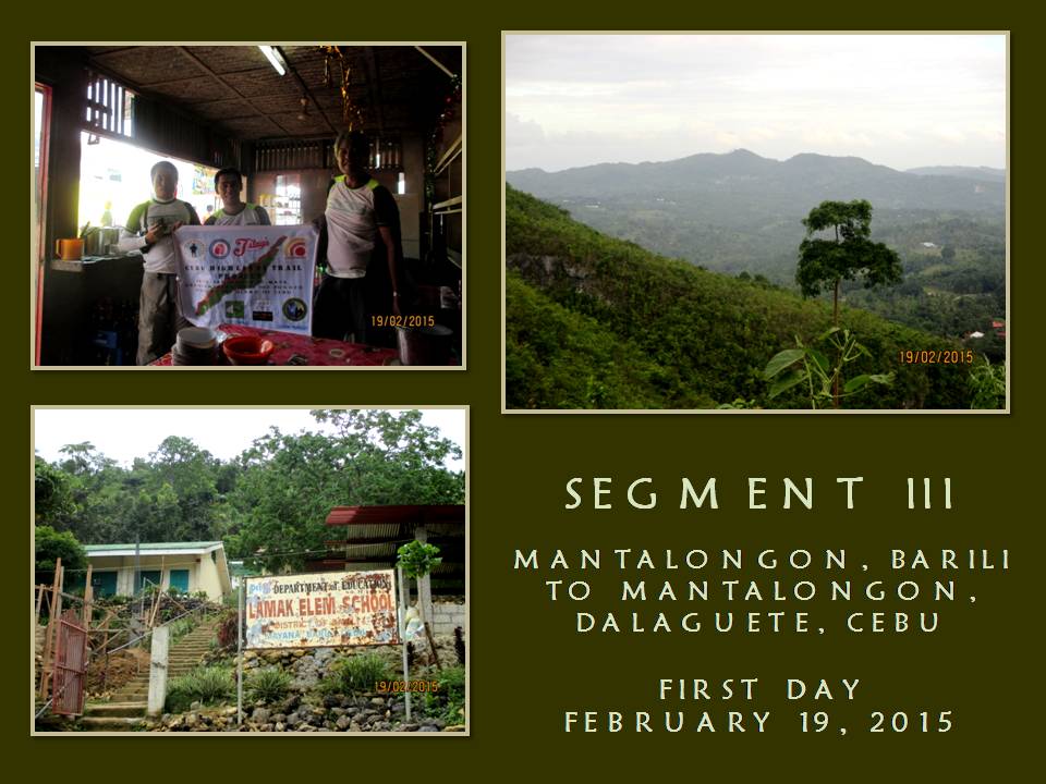

-
Leave the Cebu South Bus Terminal at 05:25 by bus bound for Barili.
-
Arrive at Mantalongon, Barili at 06:40 and then a quick breakfast.
-
Start of first day hike. Leave Mantalongon Livestock Market at 07:00 for Guadalupe Hills by trail. Pace: Moderate to fast. Weather: Cloudy.
-
Cross boundary into Guadalupe, Carcar City at 08:00 and pass by Hunob Elementary School. Begins walking on paved roads of asphalt and concrete which is known as the “Vegetable Highway”.
-
Starts communicating with Base Support of our progress by radio, through a frequency provided by the City of Carcar, and by mobile phone. Exploration Team use EAGLE ONE as its callsign while Base Support use EAGLE BASE. Radio equipment in use is a Cignus V85 VHF Portable Radio Transceiver but radio contact weak.
-
Cross boundary into Mayana, Barili and stop at Lamak Elementary School at 09:30 to rest, rehydrate and eat trail food.
-
Resume hike at 09:45 and proceed to somewhere in Sibonga. Weather: Partly cloudy.
-
Cross boundary into Basak, Sibonga at 10:30 and stop to collect specimen and to document a strange apple-like fruit that hung from a vine. The fruit is locally known as “unlan sa bitin” and its flesh tastes very bitter.
-
Stop by a communal water source at 11:30 to rest, rehydrate and eat trail food.
-
Resume hike at 13:00. Pace: Moderate to fast. Weather: Warm.
-
Arrive at the village center of Basak at 13:45. Head of village very helpful in identifying for us a mountain range situated nearby as the Tres Sierras Range.
-
Pass by Cagay at 13:50 then stop at Libo at 14:30 to rest, rehydrate and eat trail food.
-
Resume hike at 14:45 for somewhere in Argao. Pace: Moderate to fast. Weather: Partly cloudy.
-
Cross boundary into Mompeller, Argao at 15:00. Left heel starts to go painful.
-
Arrive at the village center of Mompeller at 17:00. Make courtesy call to head of village and ask permission to spend night at their multi-purpose building. Prepare coffee then supper. Food are enhanced noodle soup, fried chorizo Bilbao and milled corn. Dinner at 19:00. Weather: Cool. Taps at 20:30.
-
ESTIMATED KILOMETERS WALKED: 23
DAY
2 – February 20, 2015
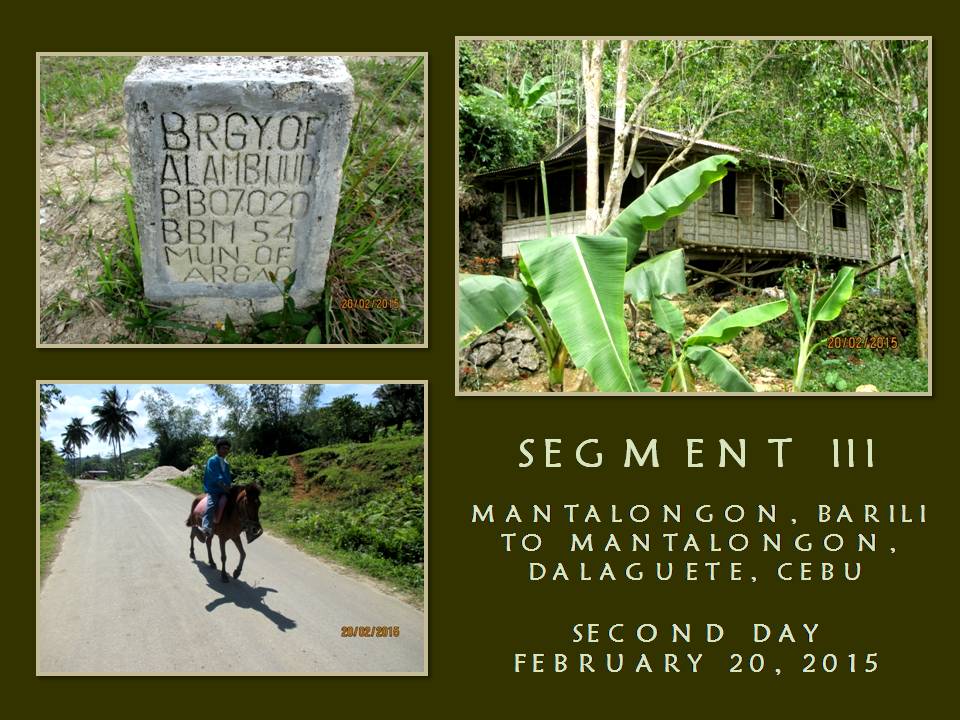

-
Wake-up alarm rang at 04:00. Prepare coffee then breakfast. Food prepared are fried beef jerky and chorizo Bilbao and milled corn. Breakfast at 07:00.
-
Start of second day hike. Leave Mompeller at 08:00 for somewhere in Argao. Pace: Slow to moderate. Weather: Partly cloudy and scattered rainshowers.
-
Pass by Anajao at 08:30 and Tulang at 09:20. Radio transmission very excellent.
-
Stop by a resting shed at 09:45 to rest, rehydrate and to eat trail food.
-
Resume hike at 10:00. Pace: Moderate to fast. Pass by Alambijud at 10:20. Weather: Warm.
-
Stop by a resting shed at 11:10 to rest, rehydrate and eat trail food.
-
Resume hike at 11:25 for somewhere in Argao. Pace: Fast. Weather: Very warm.
-
Stop at an open market of Bayabas, village of Cansuje, at 12:10 to rest, rehydrate and take a meal at a small eatery.
-
Resume hike at 13:15 for somewhere in Argao. Pace: Slow to moderate. Weather: Warm.
-
Pass by Butong at 13:50 and stop to take photographs of a huge strangling-fig tree at 14:40.
-
Pass by village center of Linut-od at 15:00. Head of village very helpful in facilitating of our coming to the next village of Balaas through radio. Weather: Partly cloudy.
-
Arrive at the village center of Balaas at 15:45. Make courtesy call to head of village and ask permission to spend night at their multi-purpose building. Head of village very helpful in identifying a mountain range situated across us as Canbantug Mountain Range. Likewise to a lone peak as Mount Lantoy and to a robust stream as Salug River. Prepare coffee then supper. Food are mixed strips of vegetable pear, pechay, green pepper and carrots; beef jerky; fried krill with tomatoes; raw sliced tomatoes and milled corn. Dinner at 19:00. Weather: Rainy and cool. Taps at 21:00.
-
ESTIMATED KILOMETERS WALKED: 15.5
DAY
3 – February 21, 2015


-
Wake-up alarm rang at 04:00. Prepare coffee then breakfast. Food prepared are corned beef, scrambled eggs and milled corn. Breakfast at 07:45.
-
Start of second day hike. Leave Balaas at 09:00 for somewhere in Dalaguete. Pace: Slow to moderate. Weather: Partly cloudy.
-
Cross boundary into Manlapay, Dalaguete at 09:25 and pass by Manlapay National High School.
-
Arrive at Maloray at 10:45 to rest, rehydrate and eat trail food. Decide to investigate and explore Mount Candungaw for possible inclusion as a tourist spot. Arrive at first peak at 11:30. Jovahn decide to explore a cave nearby while me and Jonathan proceed to second peak. End exploration at 12:30 and return to base of peak. Ordered hot noodle soup as meal.
-
Resume hike at 14:10 for Mantalongon. Pace: Slow to moderate. Weather: Partly cloudy.
-
Pass by Ablayan at 14:55. Change pace from moderate to fast.
-
Stop at a culvert at 16:00 to rest, rehydrate and eat trail food.
-
Resume hike at 16:15. Pace: Slow. Weather: Very mild.
-
Arrive at Mantalongon at 16:35. Visit first the Saint Isidro Labrador Parish to pay respects and thanks to Providence before proceeding to the Mantalongon Vegetable Market. A crowd begins to mill around us as we pose for the camera in the market.
-
Leave Mantalongon at 17:00 for Poblacion, Dalaguete by motorcycles-for-hire. Celebrate our success with cold beer and food by the seashore.
-
Leave Dalaguete for Cebu City at 20:00 by bus.
-
Arrive Cebu South Bus Terminal at 22:00.
-
ESTIMATED KILOMETERS WALKED: 15.5
This
present Exploration Team had prepared so well in terms of physical
conditioning that we shaved off a day of its original itinerary by
our pace alone. Another factor which caused us to make this a 3-day
affair instead of four is the presence of the “Vegetable Highway”.
The existence of this little-known vein of progress actually is
unknown even to some people living on the places we passed by. For
most of those who lived along it, it is a blessing.
The
Team officially have logged 53.85 kilometers of walking from Point A
to Point B, basing upon the auto computation of Wikiloc, a web-based
application which can either be manipulated by uploading GPS
waypoints or by manual tracing of the route with a mouse, but it does
not include the peripheral routes we had taken like the locations of
our billeting areas which are actually located 200-300 meters from
the main route and our climb of Mt. Candungaw. I believe we had
logged more than that.
We
each carried an average of 13+ kilos although we are observing light
backpacking. Food, survival gears and our sleeping equipment had
used up much of our cargo space. It is good that water could be had
along the route. The places where we pass by are abundant of water
so there is no need to carry more than a liter of water. Along the
route are spring boxes which pour out cool potable water for man and
beast alike.
On
the other hand, folks see our presence on most of the places we
passed, except at Mantalongon, Dalaguete, as unusual. They have not
seen hikers or outdoorsmen or urbanites with backpacks before and
they viewed us with suspicion until you break the ice by giving them
a smile and a greeting. Ultimately a conversation begins, explaining
your purpose, would make them see a bit but they cannot comprehend of
why we walk when there are vacant seats on a few motorcycles passing
by.
The
completion of Segment III is but one step closer to my objective.
The next routes would not be as easy as the finished segments nor
would it ensure favorable conditions. Definitely, the next segments
will not be a walk in the park and would demand navigation savvy from
the Exploration Team, which that responsibility rests squarely on me.
The CEBU HIGHLANDS TRAIL PROJECT from hereon goes on a high swing of
difficulty but the team accepts that challenge nevertheless.
I
have learned so much from the different segment hikes that I have had
with different teams. This present team is so flexible and very much
prepared for the physical challenges at hand that it had given me a
great assurance that we can deliver the CEBU HIGHLANDS TRAIL PROJECT
true to its schedule. I am confident that we could overcome one of
the most difficult stretch of the Project, which is Segment IV, in
October and the longest, Segment VII, in 2016.
Document
done in LibreOffice 3.3 Writer


No comments:
Post a Comment