Sunday, October 21, 2018

THE TRAILHAWK JOURNEYS: Rodriguez Rizal Wilderness Survival Class

LAST FEBRUARY 2016, an independent event organizer contacted me for a survival training, far inland beyond the Wawa Dam, in Rodriguez, Rizal. This particular organizer became one of the participants along with twenty others. I could not forget the two days I spent with them and the hosting family who originally were from Aklan. That training, came days after I had also done one with 34 individuals organized by CLIMBER.

The organizer, now my former student, arranged again another training for another set of participants, this time on the approach to the Binicayan-Pamitinan Protected Landscape, in Rodriguez, Rizal, near the DENR office. I am again obliged to travel to Luzon with my tools, educational aids and instruction manual. It is another compressed training which would run for two days on December 9 and 10, 2017.

Although I do not mind doing a training for two days, as I receive the same compensation package that I do for three days, but three days is best for both the participants and me. I only give the best instructions and the extra day would have given justice to what you spend for. An extra day would have been relaxing on my part also and, in the process, participants would not be forced to receive an overload of information. 

This training is called the BASIC WILDERNESS SURVIVAL COURSE. It is designed for tropical wilderness settings of dense jungles and rugged highlands, which I first offered to the mountaineering community in October 2013. It is open to all individuals or groups of any interests and purpose. Attending now are fifteen people, to include two minors. The training is done inside a local resort.

The first chapter is Introduction to Survival. Survival situations demand that you stay tough after the initial impact. Mental stability and toughness are very important characteristics of a survivor. You must develop a survival mindset. Do not engage in prolonged mind games of fantasy and false hopes. You should rein in your mind so you would not release excess adrenaline and cause you more confusions in a very stringent moment.

The best thing to do is stay still and fill up your lungs with oxygene. Your brain needs it most to help you process thoughts. You are now in a high state of agitation and so does your brain. Your brain will be in hyper mode, collating and processing many thoughts all at the same time which is beyond human capacity. We can do so one thought at a time. Just stay still and breathe regularly, supplying your blood system with oxygene.

In the hierarchy of needs and of nutrition in a survival situation, water is always on the top of the scales of both. Rightly so, for we are in the tropics and humidity plays a big role. With that, we surrender perspiration by the acts of our exertions and by what the climatic conditions imposed on us. Along with the lost moisture, is our body heat which we let go without our knowing.

When you stay still in one place, you lessen wastage of moisture and body heat. Then you confine the latter by setting up a shelter (if you still have one) or make one from scratch. That is the second need. The third would be food then warmth. Although food, and even water, would give you warmth, but heat from a naked flame or from the rays of the sun or from a person’s body is solace. Last is security which would complement well with the rest.

Our body has four hypothetical storage tanks that needs to be replenished from time to time during survival. First is constant rehydration that would offset dehydration. Second is food that would give you nutrients, carbohydrates and proteins. Third is sugar which is converted by enzymes for your adrenaline rush. Fourth is fat, hardest to find in the tropics yet are wrapped as tissues in our body.

The topic for the next chapter is about Water Sanitation and Hydration. The first chapter had mentioned the importance of water during survival. Water could be sourced from natural springs, water seeps, man-made water holes, flowing streams, the atmosphere and from plants. It could be refined through boiling, by chemicals, exposure to heat, through filtration and by desalination. It is wise to cache water in your survival camp or just travel early and take advantage of shady places and breeze if you happen to have less.

We move fast to the third chapter which is about Knife Care and Safety. The knife is a tool and should not be used to what it was not designed for like digging holes and as pry bars. It is a vital piece of equipment that should be properly handled and cared for because it is your link to your surviving. In all my training, knife etiquette is learned first before you touch a knife, so as to lessen accidents.

Besides that, there is a knife law that forbids the display, even of concealed carrying, in public places unless you are in a lawful activity, which we are in right now. A knife should be in a sturdy sheath when travelling and should be unsheathed when at home to keep it from rust. There are many kinds of knives and it is important that you know the parts, blade shapes, grind styles and the tang designs. You must also learn how to field sharpen a knife.

I was able to finish three chapters in the morning and noonbreak is mandatory when the clock struck twelve. There is no cooking as food is prepared by the family-run resort. After lunch, the hammock is an inviting proposition and I sneaked into its comfortable grip for a quick nap. I needed the rest to keep my mind sharp since the participants would be handling knives later. Refreshed after 90 minutes of siesta, I continued with the activity.

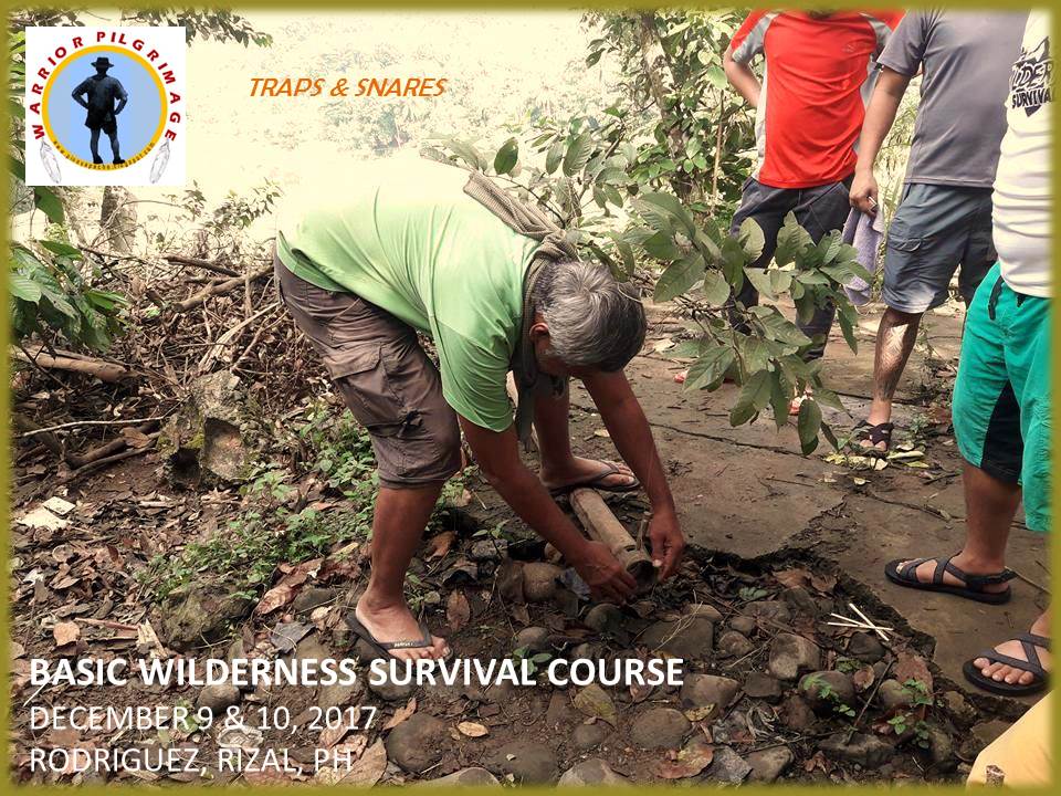
After the much appreciated instructions about the knife in the morning, we moved on to Survival Tool Making. Using a tool is essential in survival or even when not in that situation. I showed them the most basic of tools like the digging stick, traps and snares from pieces bamboo that I prepared, and the batoning stick. I let each carve a spoon on bamboo to practice their dexterity with a knife while supervising the practical exercise.

Following this is the chapter on Notches. There are five basic notches that are used regularly in bushcraft. These are applicable in shelters, furniture and tools. Again, this is another exercise in knife dexterity but it can only be achieved with the use of another tool, the baton stick. On a single stick that served as an art canvas, each participant carved their five different notches, starting with the easiest up to the most complicated.

Next is Fire, Fuel and Campfire Safety. You cannot make a fire if one or all elements are not present, namely: fuel, heat and air. Lately, they added a fourth element – chemical reaction. Fire-making is 80% common sense, 10% skill and 10% perspiration. We are talking about the friction methods. Your fire can start if you can acquire and identify the right tinder, if you are in a dry place, and if you have the patience.

Aside from friction, there is the conventional method which are matchsticks, lighters, ferro rods and the flint and steel. Then there is solar magnification which can be done with any lens, reading glasses, water and even ice. Then you have pressurized air, exemplified by the fire piston. Since I do not have the luxury of time, I limit my demonstrations to the flint and steel, which I paired with charclothe, and the ferro rod. I showed them how to make a tinder bundle. 

Showed them how the bow drill method is made and spun. Unfortunately, I could only make thick smoke as sawdust embers refused to light up my tinder. Humidity is very high since we are beside a big river and there is a promise of a downpour. I let others try the bowdrill, the ferro rod, and the flint and steel. The teenagers among them were able to light the charclothe. Unfortunately, we cannot do with the bamboos because the dry ones have not been stored properly and are all wet.

A strong downpour came as expected and we have to end the first day. The activity on primitive cooking using bamboo could not proceed. The storage of firewood, along with dry bamboo had been left to neglect. I have to dry just a few after I have set my shelter in the morning and left the rest to the onslaught of rain when the rush for the safe shelter commenced.

Likewise, the activity on Nocturnal Hunting has to be shelved. The Marikina River has risen and very turbulent and is not safe for people. The good thing about catered food is you appreciate it in times of rain but I have seen a lot of cooking in the worst of times and today is no exception. Should have but the organizer designed this as it is and it is beyond my control.

When the rain stopped, the Campfire Yarns and Storytelling pushed through naturally. A small fire gave the participants a reason to gather around in a circle. I have to gather the drenched firewood nearer the fire to wick it away of moisture so it would be fed next as campfire fuel. A bottle of brandy appeared and the glass made its way among the adults animating more of the stories. The evening program ended at 23:00 and the hammock is most appreciated.
 
The second day (December 10) start with Customizing the Survival Kit. It is better that survival kits are made from scratch than bought commercially because a survival kit’s size and its components depends upon the type of the activity you are indulging in and the kind of environment you are going to visit. Your personal preference still matters. The components should include the medical kit, the replenishment pouch, the repair kit and a small knife. It could all be integrated in one container and should be waterproofed.

Next is Foraging and Plant Identification. Foraging food in the wilderness or on unfamiliar terrain can be very taxing to the mind. When you are stressed and hungry, you tend to remove all caution. Looks can be very deceiving in the tropics like fruits, leaves, nuts, roots, flowers and mushrooms. Likewise, you need to evade harmful plants while travelling your way in a jungle.

Short term food would be grub, tree snails, fresh-water shrimps and crabs and frogs. These can be picked by hand. Cook it if you must to remove parasites and bacteria. Long term food are meat from mammals, fish, birds and reptiles. For that, you must use a weapon or traps and snares. Traps could be anything designed to lure prey into a simple contraption of a hollow bamboo or a dam of rocks. It must work with the terrain, with gravity and the habits of creatures, including its anatomy design.

Snares are more complex. It has a spring mechanism and a trigger mechanism which would be initiated by the prey. Showed the students a very common snare employing a pressure-trigger mechanism. It could catch anything from birds to goats. Another is a tube snare popularized by the Aeta. You must use bait so prey would be lured to set it off. A single trap or a single snare would not yield you a catch but a trap line of 20 to 30 of these, after ascertaining where prey would most likely pass or visit.

 
Related to these is the chapter on Food Preservation and Cooking. If you can eat a deer all in one setting, well and good. You are very fortunate to still possess a healthy appetite. Meat rot in a short span of time. During survival, meat can be preserved and its edibility can be extended for a few more hours to several months. You can boil it. You can dry it. You can smoke it. Or you can cook it with its own oil from its fat.

Fish can be preserved by drying and by smoking. Fruits can be digested after a drying session and provide you natural sugar. Common rootcrops, has high starch value, and should be cooked, by all means possible, to remove toxins and poison. Famine crops need to be immersed in running water for five days before cooking. Salt and vinegar are good food preservatives. Vinegar can be sourced from any palm.

Next is Navigation and Understanding Trails. This is more on traditional navigation which use the natural terrain, shadows and the sky fixtures for travel; avoiding obstacles and exposed areas; and knowing how to identify signs on trails made by both animals and humans. Following that is Understanding Cold Weather. During survival, exposure to the elements is expected. There are five physical mechanisms that steal away body heat and the things that we should do to keep us constantly warm.

Dusk would soon come and we have to break camp, intending to finish the last chapter which is Outdoors Common Sense. This is based from my yet unpublished book, ETHICAL BUSHCRAFT. It is about trail courtesy and behavior while on the trail; choosing the best campsites; practicing stealth camping; increasing individual safety and security; wildlife encounters; and introduce people the idea of Blend, Adapt and Improvise.

We finished the training with a blade porn. It is a traditional bushcraft activity where all edged tools are laid together in one place to inject another round of useful conversations and to encourage closer camaraderie among the participants. What resulted was the presence a considerable number of high-quality imported blades and rare local blades. It is now almost evening and we took dinner.

The van-for-hire that took me here two days ago from Cubao, came back to bring me back there. The organizer made sure of that. From Cubao, I took a bus bound for Navotas where an invitation for a second dinner awaits me and, of course, a refuge to rest a few days before my departure back to Cebu. I am tired, not of the training compressed in two days, but from a trusted person who failed to keep his end of the bargain. It is one of the hazards of a journeyman and it is sad.

Document done in LibreOffice 5.3 Writer
Some photos by Vernie Tuason and Franz Tiu

Thursday, October 11, 2018

MAN-SIZED HIKE XXVII: Manunggal-Babag-Lutopan

THE CEBU HIGHLANDS TRAIL is a long trail comprising of roads, dirt paths, farm trails, highways, even an old railroad and a stretch of trackless wilderness from southern tip to northern tip. These were stitched together by this blogger for almost six years before being hiked through in 27 days last January-February 2017. You would marvel at its length and you would be amazed that this blogger walked it on sheer memory.

It is divided into eight segments, the author noting that a guided thruhike is a far possibility as of this time since the routes had not been documented by any radionavigation system, being the CHT is but a product of memory borne from the oddities of traditional navigation. In segments, the CHT is simply manageable and the chances of error are small which could be rectified by creative ways.

 
In segment hiking, you could either start from the heel of Cebu, going up north to the “finis de tierra”. Or you could do it in numerical order from Segment I to Segment VIII. Whichever, the author simply designed it for the convenience of travel, with easy access from start and finish. Segments vary from two days to as much as five days. Segments also make it easy to carry your load of gear, food, and fuel and other supplies.

I have not yet opened it for guided walks but I accommodated the request of the Bukal Outdoor Club, for them to try the CHT. I have complete trust in this group for they trained themselves in jungle survival and wilderness first aid. They choose Segment I, the route that would start from Mount Manunggal then to Mount Babag before it terminate at Lutopan, Toledo City. This could be a test hike and to test my memory.

Segment I is one of the most difficult hike of the CHT and could stretch from 56 to 60 kilometers in length. It pass and traverse over three major mountain ranges: the Central Cebu Mountain Range where Mt. Manunggal is located; the Sudlon Mountain Range; and the Babag Mountain Range where Mt. Babag is located. It also cross two major river systems of Cebu: the Lusaran River and the Mananga River.

 
After lunchtime of November 30, 2017, we left the terminal at Ayala Center. Thirteen members of Bukal Outdoor Club came and two from the Camp Red Bushcraft and Survival Guild. We have an itinerary to follow which is very important since it would determine the food we bring. Going up and down difficult terrain for five days hefting heavy loads is not easy, especially under a warm tropical sun.

We alighted at the Trans-Central Highway where there is a feeder road that lead to Mt. Manunggal. From there we follow this dirt road which pass by the village of Sunog, Balamban. The village now charge visitors eighty pesos each if you camp at Mt. Manunggal, which we will soon be, and at Mt. Mauyog. Personally, I do not have any qualms about this if it benefitted the folks and improved the services, then, so be it.

We arrive at 16:00 and set up our shelters. Part of the entrance fee is the use of the bathroom and piped water. Which is fair enough. I do not know about how the caretakers dispose of other people’s garbage. As far as I know, hikers and mountain climbers take care of their own garbage and bring it with them. I believed the bulk of the garbage are those that are brought by locals, especially during the annual March 17th revelry.

It was strangely warm in Mt. Manunggal where, in another time at that hour, it would have been already awfully cold. I expected a sleepless night since I would be laying down in a hammock under a simple shelter of taffeta sheet which are open on two sides. The ingredients for their first meal is now dispatched into a grand dinner. There was a glass of brandy doing the rounds and I stayed until about 20:00 when wind begun to chill a bit.

When it was still dark, and cold, hushed voices awakened me. In the clear air, the metal clank of pots are distinguishable and I could hear the hiss of a butane stove. Somebody woke up so early to prepare breakfast. I would want to rise but there is not much I could do except slurp coffee. I could do that later. The second day, December 1, is really the start of the Segment I hike. The start of their adventure.

After a filling breakfast, we break camp and started very early at 07:30. Our first destination would be Inalad Saddle, which the itinerary says we will reach at 12:00. We would be following a trail that only a few people use and it goes down the upper part of the Lusaran River. I know this path well, having passed by here on many occasions until someone closed that part which offered shorter route to Inalad.

 
We go down from Mt. Manunggal over a very beautiful trail, grassy and forested and squeezing among rocks in a tight cleavage until we rest by a place called Kapiyoan. Going with us is a dog from Sunog. It followed us because we have food to spare. From there, we go down some more among cleared patches, solitary houses and swidden farms and cross small tributary streams and landing on the sandy shore of the Upper Lusaran.

We cross the stream five times and climb up on the other side and follow a narrow trail that follow gently the lower contours of a mountain range of Cantipla. We ultimately reach Inalad at exactly 12:00 and buy prepared food from a local restaurant. One of the hikers  has to cut short participation because of prior commitment. Inalad is a marketplace and is the common boundary of Balamban, Cebu City and Toledo City. After lunch, we spend our deserved siesta. So is our guest dog.

At 13:00, we continue on our way by crossing the Trans-Central Highway into the side of Toledo City. There is another feeder road that would lead to the village of Tongkay. It snaked its way, gently meandering into a valley surrounded by mountains. When we reach the village, we registered our names into their visitor’s log after a courtesy call. We cross the Upper Hinulawan River, which drains to Malubog Lake, and climb Mount Tongkay. 

This is another good trail but you would not appreciate it since the warm early afternoon sun would be directly facing your right. Although it is well vegetated on both sides, the path is bare. The trail goes up and up until it becomes tricky. While the trail goes on its hog back, I prefer to cut across a hillside farm, oblique, right on the face of the mountain until I come upon low vegetation where I turn at a right angle towards the campsite uphill.
  
Before climbing Mt. Tongkay, everyone filled their water containers full at village since the nearest water source would be at Etwi, half a kilometer away. What weight they disposed to the two meals at Mt. Manunggal were replaced by water and everyone struggled the trail to this campsite, which we reach at 16:30. Tents are set up on the open ground while Jethro and I opt to sleep above ground in our respective hammocks.

Soon there would be a spectacular moonrise as the moon approaches its full waxing in two days. Across the campsite is the saddle of Inalad and the imposing height of Mount Gaas. Further away, lost in its mantle of clouds, is Mt. Manunggal. We are overlooking the valley and, soon, warm air from below would slowly rise, giving us a comfortable night with just the right temperatures. A forest rising from the other side protect us from the south wind.

Dinner is prepared hastily while there is still daylight and our adopted dog liked it very much. We made a campfire to celebrate the good hike for today. Another glass of rum make its round among the campers under the silvery light of the moon. Wind shrieked among the lower valley yet it never affected us. It was comfortably warm in our campsite. When the last of the fiery liquid were completely gone, we made for our waiting shelters.

The third day, December 2, made its presence known with the crowing of the cocks, tame and wild, and by the hiss of the butane burner. The camp becomes alive as daylight augured for another round of adventure. Segment I is divided into two sub-segments. The first installment, the ones we have walked yesterday and later for today, is unknown territory which this author and only a few has walked.

After breakfast, we break camp and kept to the trail to Mt. Tongkay. On its very summit is a deep vertical hole, perhaps the vent of a large copper mine and everybody carefully study its depths from the lip. Continuing on, we followed the path on a narrow ridge that connect to Etwi Peak. Landslides effected a difficult passing underneath the mountain but all made it safely. This ridge goes on to another ridge which becomes the Sudlon Mountain Range.

We arrive at Maraag, in the village of Sudlon I, and there is a store that sold cold soda drinks. We stayed here for about ten minutes. There is now a road here that connect to the Trans-Central Highway if you go north. We go north but we veer to a feeder road that goes to Panas. It is a dirt road with several trailheads, tempting you to take one. I have taken each and every trail in the past, borne out of confusion, stress and failing memory.

Never have I stuck to one path on those occasions and I was literally lost except for my first attempt. That path is the one I am looking for. I have to be accurate this time. I have fourteen people to take care of and our line would stretch long on “uncharted” territory. I found the trailhead and my confidence builds up. The trail lead us to solitary houses, farms, headwaters, forests and grassy meadows. It is a warm day and my memory begins to lose some.

I have to backtrack on one when I found going the wrong way and I have to reconnoiter on other times, the stress begins to build up on me and I have to call a time out at 11:00 as the sun bore its intensity on me. I begged for coffee underneath the shade of a big star apple tree. I have to rest else I would burn out. The rest for thirty minutes, coupled with coffee and powdered juice, have stabilized me and I took the trail once more with gusto.

The trail goes on its serpentine path, going up and down, mostly down, until I reached the home of Yolando Obong at 14:00, whose place I passed by in 2015 during a penitence hike. The house is abandoned yet there are fighting cocks leashed to the ground while hens and chicks rove around and everywhere. Mr. Obong would be back later to feed these fowls, I am sure of that, but I could not wait. We rest here for a while and fill our bottles from a spring.

We must go down to Biasong Creek then go to Mt. Babag and we have squandered a lot of time that we are now behind schedule. Once we reach safely the village of Bonbon at dusk, it would be alright to walk in darkness to our next campsite. We leave for the stream, following a trail which I thought was the one based on a two-year old memory. Although I passed by here in January during the Thruhike, it was done in reverse from Biasong Creek.

We go down a steep and difficult route inside a jungle. There were trails but it ended on holes where charcoals are made. I tried the gully but I stared on a very steep precipice as it is a dried up waterfall. My hair stood on its tiptoes as I realized we could all be swept away to kingdom come if ever there is a big downpour. I advised everybody to backtrack and go back to where we came from. My memory simply failed me again and I am tired.

It is now 15:30 and too few daylight hours to make another try to the stream. We have to go back to Mr. Obong’s place and set up our campsite. We have adequate water there. Defeated, I set up my hammock and shelter far from the rest. Dinner is prepared. There is another spectacular moonrise over the Babag Mountain Range, the place where we should have set up camp tonight.

Mr. Obong arrived at 22:00 and how I was glad to see him and talked to him about our earlier debacle. He is feeding his fowls in the dead of night for his late arrival and he promised me the correct path early morning. He also warned me that strange men not from his place pass by here at dawn. He just leave them alone. True enough, there was a man in a hurry passing by where I slept at around 02:00 and he was not carrying a torch.

The fourth day, December 3, saw us falling behind schedule by almost 24 hours. I have to remedy that and do some improvisation once we reach Biasong. We thanked Mr. Obong for his help and for accommodating us in his ground and bade goodbye. Refreshed from a good night’s sleep, I am now on the trail to Biasong Creek at 07:00. The ground is slippery as it is steep with very few good handholds to anchor since most plants here are spiny.   

 
After 45 minutes, we were on the stream. The water is at a moderate level. We followed an invisible path where we are able to keep our shoes dry. While trying to grip a steep rock face, one of my shoes slipped from a slippery toehold and I fell into a waist-high depth, totally incapacitating my use of my Lenovo A7000 smartphone and my Cherry Mobile U2 analog phone. Without these, I cannot give updates of our locations. 

We arrive at Biasong at 10:00 and sucked dry, bottle after bottle of cold soda drinks. We haggled with a Suzuki Multicab owner and we were transferred, all 15 of us and a dog, to the place where we were supposed to spend our campsite last night, disregarding the need to cross Bonbon River and walking the road to the Trans-Central Highway and to Mt. Babag. Even with that, we are still a full five hours late. It is almost 11:30 and we eat lunch brought by another Bukal Outdoor Club member who joined us.

Fully rested and full, we continue at 12:00, following the dirt road, passing by Mt. Babag, until it becomes a mere trail. The Babag Ridge Trail is a beautiful stretch of forested country unknown to a lot of people. Lately, new hikers begun to discover this and they failed to know the places where the old World War II trenches and tunnels were located. Everyone were aghast at this hidden gem and it goes through another forest, mostly of crawling bamboos (bokawe) and, facing before us is, Mount Bocaue.

We did not climb the peak as we were on a hurry. We are racing with time and there are too few daylight hours left. We need to be in the village of Buot, Cebu City before sundown and walking in darkness into our next campsite would be okay since we will be on roads. In the meantime, we are on a trail yet and following a wrong one would spell disaster to our itinerary. I concentrate on landmarks instead of being concerned with time and pace.

This is a long ridge. We are walking almost the entire length of the Babag Mountain Range. We reach Mount Samboryo and my worries of getting lost are losing its grip. The trail goes down but some people before us, on board dirt motorcycles, have ruined the path, loosening a lot of rocks and tearing soft spots which became difficult to tread on. These people simply do not respect the locals who used these trails for their livelihood and for their children going to school.

We cross a hanging steel bridge and arrive at Buot at 17:00. We douse another batch of cold soda drinks before going the long way to Odlom. This time, we would be walking uphill on a combination of paved and dirt road. It is a long uphill walk. The soles have seen its beating from four days walk and extended for another many hours of night walking. It begins to be painful as the leg joints begins to complain.

 
The pace becomes controlled and careful so as not to overburden the feet soles. We arrive at Odlom, a part of the village of Sinsin, Cebu City, at 19:00 and we have to walk another hour to the Manipis Road and then 30 minutes to Camp 7, in Minglanilla. It extended to two hours because of frequent rests. At 21:00, we finally arrive at the DENR’s Biodiversity, Coastal, Wetlands, Ecotourism Research Center for our day’s campsite.

Our stay at DENR-BCWERC was made possible through my request which was approved by Dr. Alicia Lustica, the center head. It is composed of the Cebu Experimental Forest, a nursery, caves, trails, a small waterfall and wildlife. Unknown to most people, the center accepts ecotourism tours as it has a 240-meter Kiddie Trail; a 1.3 kilometers EcoDiscovery and Heritage Trail; and a 1.2 kilometers Ecstacy Trail which include visiting two caves.

Dinner came at 23:00 and it was another grand meal worthy of remembrance. There was a bottle of brandy somewhere but I opt to chase sleep. I am really tired. I was using the wrong bag. It was the Mil-Tec rucksack whose waist belt was inadequate to transfer the weight to my hips from my shoulders. I was hefting all along for the past four days the whole load on my upper body. I was supposed to reserve this bag for overnight trips only. Memory fail again.

The fifth day, December 4, is just a stroll in the park. Our destination is Lutopan, a progressive mountain village of Toledo City. We left the DENR-BCWERC at 09:00. The road goes down but long and paved. We are nursing bruised soles. What more for our adopted canine who walked bare? We reach Lutopan at 12:00 and rode a bus bound for Cebu City. What a great canine migration and adventure.        

Document done in LibreOffice 5.4 Writer
Photo credits to Apol Antenor, Kier Mancao, Nyor Pino and Mariel Reyes

Saturday, October 6, 2018

BUSHCRAFT BUHISAN XLVI: Jungle Steam

IT IS A SPECIAL DAY today, November 26, 2017, for the Camp Red Bushcraft and Survival Guild. We have a special guest whose blades provided the tools for our dirt-times and became synonymous with Philippine bushcraft. Dr. Arvin Sese is in town. Taking timeout from his busy schedule, Doc Arvin happily joined the bunch in our hallowed playground at the old Camp Damazo, the site of the first Philippine Independence Bushcraft Camp in 2011.

While the weather was very depressing the days before, today promises a very warm day. The sun shone gloriously on the parking lot infront of the Our Lady of Guadalupe Parish, Guadalupe, Cebu City. When I arrived, Ernie Salomon, Richie Quijano, Vlad Lumbab, Glyn Formentera, Nelson Tan and Jenmar de Leon were already there. Then came Aljew Frasco, Eman Apuya and Boblyle Balverde. Arriving last in an Isuzu passenger van are Jhurds Neo and Doc Arvin.

After securing the food ingredients from the roadside market of Guadalupe, we leave as one on board the Isuzu at 08:15. We arrived twenty minutes later at Baksan and proceed to the trailhead. The path led to a man-made exotic forest of Burma teak. The ground is wet but not muddy. Going downhill, we follow the same serpentine path to the Banauan Creek. The stream is brisk but clear, its ripples sweet music to the ears.

I am leading the pack and I made it sure that the pace is favorable for Jhurds, Vlad and Doc Arvin, especially now that we are following the stream down to its intended union with the bigger Lensa Creek. We would not be going to the catchment basin of the Buhisan but we would be on higher ground instead where it is much safe. We reach the old site of Camp Damazo at 09:30 and staked our dirt time here.

 
The heat of the day made the jungle very humid as steam rose to the canopies. While the rains may have left a wet surrounding, we at the Camp Red Bushcraft and Survival Guild know where to source dry kindling, tinder and firewood. I taught these guys and I am mighty proud of them. If we do not find them, we have these in our fire kits. The guys automatically spread out to look for dry fuel.

An uneasy flame appeared underneath a wooden tripod standing high and a little gentle coaxing from Aljew, this flame begins to gain warmed up spaces around its small circle of half-moist tinder and kindling until it became confident to burn bigger fuel. Thick smoke rise and a crackle of fire announced to all that it is ready for the pyromaniacs. A pot hanged from the tripod and coffee is in the first order of things.

   
Doc Arvin, tired from his travel from Carcar City, 41 kilometers away, set up a hammock in between two trunks and, in an instant, a blissful snore sounded off. He says he stayed a full vigil the whole night at the Carcar District Hospital treating and caring patients. He is a government doctor who is on loan from a government hospital in Pangasinan. He would be going back to his home province after a few days.

Dr. Arvin Sese, together with his brothers, owned and sold knives under the SESEBLADE brand. I first saw a Seseblade, an NCO, during the 2012 PIBC. Since then I have used their blades in all my bushcraft and survival classes everywhere in the country and endorsed the Seseblade before participants. Aside from the NCO, Seseblade also has the Mountaineer, Sinalung, Nessmuk, Matavia, the JEST Bolo, Parang and the Tomahawk.

It is known that I just used a 9-inch Seseblade Straight NCO over another bigger blade to work my way through the forbidding wilderness of the Doce Cuartos Mountain Range in Tabogon during Day 22 of my Thruhike of the Cebu Highlands Trail. Even though small, the local blade performed well in a tropical jungle environment with just a flick of a wrist, a method that shies away from those cinema-type hacking which is tiring and less effective.

After drinking coffee, I found the rest of the gathered firewood partly moist so I decided to augment theirs with dry ones. I see a waist-high stump and started chopping on one side with my AJF Gahum. Although the outermost part is moist, the next layers were completely dry. Storms and downpours could not penetrate the grains and it shall remain dry although it looked wet on the outside. The wood from the dead trunk provided good fuel for the cooking.

The guys were busy with the cooking and they were deeply buried in their conversations. I need not disturb that equilibrium so I dragged a cheap laminated nylon sheet from my Lifeguard USA rucksack to a place where there is shade. Unmindful of the dear doctor’s snoring and the roars of laughter from the river bank, I tried to squeeze a few minutes of sleep, which I did, until my Yaesu FT270R picked up a wayward signal.

I do not know how many minutes did I sleep but I felt I was cheated. It felt that I enjoyed it in a few seconds only. I did not feel revived nor was I short of being tired. The struggles of the camp fixers of their food have not yet seen its finale but there is still brewed coffee in a billy can. I could try another cup. The snores are still there and I envy Doc Arvin. More jungle steam rising to the branches and humidity is high.

The last of the meat is almost done on open ember. The aroma is overpoweringly sweet, teasing my hunger to its ultimate borderline of instability. Doc Arvin could have felt it too as the snores have stopped and the hammock moved to reveal a couple of lower legs dangling and reaching for the ground. I see a smiling Doc Arvin, quite refreshed from his half-hour of sleep. Ernie removed the last one and Vlad sliced that with his scary-sharp blade.

Lunch begin at 12:30, fair enough to feed a mad and famished man. Aside from grilled pork, liver estofado and raw cucumber in vinegar got served with unlimited rice. The pot bottoms are scraped clean leaving less for the ants. Conversations regained its momentum with the clank and clink of metal competing for earspace as it gets a scrubbing from sand near a water hole.

By 13:30, it was time to move off. Doc Arvin has to leave Cebu City for Carcar City at 17:00. After cleaning up Camp Damazo, leaving as little traces of our time here, I led them to another trail. I would have loved to go the way we went in but it is longer. The trail I am following now is steep but we would be at the trailhead in shorter time possible even if we tarry a lot for rests which is natural.

We are climbing a peak which I jestingly call as “Boy T’s Hell” and it is steep. We overcome two false peaks before arriving there. This peak, I first climbed in 2010 with Boy Toledo and Ernie during an earlier exploration of the extremities of the Buhisan. It was here that Boy almost collapsed of dehydration, fatigue and disorientation. I gave him all my water and it revived him but the peak was hell for him.

We arrived at Boy T’s Hell at 14:30 and before us is a long ridge that connect to another ridge and, on that day, it was beautiful to gaze at, unlike the last time I was there. Across us is the pyramidal shape of Bokatol. We arrived at Baksan at 15:30, time good enough for Doc Arvin to be at the Cebu South Bus Terminal before 17:00. We immediately leave as one on board the Isuzu and reached Guadalupe.

We say goodbye and thanks to Doc Arvin as Jhurds drove the Isuzu to the bus terminal. It was my first time to see and talk to Doc Arvin in person yet it seemed we knew each other for a longer time. In this strange interest of bushcraft, I have encouraged my adherents and students to patronize local products, most particularly, local blades. Doc Arvin has been most generous to provide me his designs and prototypes and I was a willing ambassador.

Document done in LibreOffice 5.4 Writer

Monday, October 1, 2018

NAPO TO BABAG TALES CXXVI: Bukal Outdoor Goes Wilderness First Aid

BUKAL OUTDOOR CLUB is one of just a very few outdoors group that I know of who took very seriously their interest of visiting mountains, hiking and camping. They are striving to equip their members to stock knowledge from seminars, when available, and they are very cooperative with each other. To remember, they have taken wilderness survival training from this writer last May 13-15, 2017 and I want them to learn more.

Fortunately for them, the Camp Red Bushcraft and Survival Guild is hosting another Wilderness First Aid training on November 11, 2017 but it is not confined to their members only. I invited Bukal Outdoor Club to participate in this activity. Instructing again for the third time is Shio Cortes, formerly of Cebu PDRRMO but now has his own outfit – Strategic Options Safety Solutions. Assisting him are Val Cruz III and Christopher Ngosiok. All are registered nurses.

This is a rare opportunity for Bukal Outdoor Club to learn from people who know their business well since this is an open event. We start from Napo after a short motorcycle ride from Guadalupe. The day is perfect and warm. We will be on a short walk only to a place where I recently host several outdoor activities. It is a small open plain found beside the Sapangdaku Creek but it is totally safe and high enough from a flood.

We arrive there at 09:00 and choose a ground under the shade of star apple trees. Everybody formed a semi circle facing Shio, Val and Christopher. Shio starts the introduction about Wilderness First Aid. It touches on the whole context of WFA and then the overview of emergency response which are focused as Locate, Access, Stabilize and Transport or LAST. Then he distinguishes the difference between Search and Rescue as against Search and Recovery.

Christopher demonstrates how the Primary Assessment is performed by assessing first the scene of the incident and the manner by which the victim was found. When examining patient, if unconscious, is to feel the airway for signs of breathing and then check pulse. Where no breathing and pulse are felt, proceed to CPR or the cardio-pulmonary resuscitation. Again check airway. There may be obstruction of foreign objects else, if patient is healthy but only choking, proceed to effect the Heimlich maneuver.

If patient is injured, proceed to the management of bleeding by (a) direct pressure, (b) elevation and (c) applying pressure points. The fourth – by tourniquet – should be applied as a LAST OPTION only! The rule of thumb would be that the affected part where tourniquet is placed should be released from pressure every fifteen (15) minutes and it should be applied to not more than two (2) hours. Failing that, it causes suffocation and permanent damage of arteries of the appendage.

For this part, the participants are urged to join in and use triangular handkerchiefs, bandannas or any other type of thin clothing as cravat bandage to wrap imaginary wounds or to stabilize fancied dislocated joints among themselves. Then these same cravats are used to perform a tourniquet on each other. A more sophisticated tourniquet could be performed by even on himself. It is called the Combat Application Tourniquet.

Other injuries which cause patient difficulty in their mobility are the muscoskeletal injuries which are simple fractures and complex ones which can be remedied by providing splints to the affected part to prevent unnecessary movements. Immobilizing the affected part is very important also when patient is a victim of a venomous bite. The purpose really is to delay the suspected venom or poison to travel quickly to the brain through the veins and arteries. Treat each bite as venomous or, at the least, as carrying rabies.

A slight downpour interrupted our activity and everyone took a break preparing their noontime meal. Ernie Salomon, Jhurds Neo and Jonathan Apurado prepared food for the participants. Food served were grilled pork, mung bean soup, cucumber in vinegar and it is laid on banana leaves, along with rice, another grand mimic of the Philippine military's popular “boodle fight” fete. Lunch was dished out at 13:00, a trying hour of empty stomachs yet warm enough to promote good appetite.

After lunch, laminated-nylon sheets are then made available to the participants to try the patient assessment among themselves. By now, rain have stopped and “patients” are now more willing to be scrutinized like Atty. Rany San Juan of MEZ II and Atty. Bruce Ragas of POPCOM VII. From patient assessment, the participants practiced immobilizing injured parts and applying splints.

Last topic is patient transport and packaging. First to be discussed are the easiest and which are the most commonly practiced like the single and the two-man carries. Then the most complex carrying-and-packaging methods are demonstrated where you need ropes or cords, sturdy sheets and some common everyday items. Evident of these methods are the Daisy Chain Package and the Georgia Litter Rig.

One improvised litter setup is using the ball cap and the small backpack to prevent unnecessary head movement where the visor of the cap acts as an improvised neck brace and the backpack's waist strap are used to hold the forehead from swaying side to side aside that it acts as a cushion to the back of the head. Officially, the training ends at 15:30 as the skies begin to show signs of rain again.

For this life-saving activity, Camp Red is indebted to Shio Cortes and Val Cruz III and we presented to him our token of appreciation, courtesy of the club president, Jhurds Neo. Likewise Christopher Ngosiok will have his token soon on an unspecified date. We were fortunate that they have pushed on again with this event even when they have very busy schedules and the activity was threatened again by a downpour.

Bukal Outdoor Club and the rest of the participants have gained additional knowledge in wilderness emergency response where improvisation and adaptation would spell the difference on the survivability of a patient, granting that professional aid and hospitals would be several hours away. The training would be very useful to Bukal Outdoor Club as they will embark on a five-day 56-kilometer segment hike of the Cebu Highlands Trail from Mount Manunggal to Mount Babag to Lutopan on November 30.


Document done in LibreOffice 4.3 Writer