Tuesday, July 26, 2016

THE BOND OF THE FIRST BORN

THE OPPORTUNITY TO TRAVEL on a weekend to Bohol is such a good thing. The Bohol that is in my mind is a Bohol that I once knew which, surprisingly, still had retained its rustic beauty. But this time, its special significance on my boyhood memory had evolved into something of a different dimension. My bond with the island is not ordinary. It goes beyond comprehension.

I am overwhelmed of my thoughts as I lay on a cot of the small boat going to the Port of Talibon on a warm night at sea. I feel a sheer longing, bordering on the sentimental, which caused a few tears welling in my eyes. I was not born in Bohol. My mother was but it was in the middle of a harsh war where my grandfather was forced to hide from the Japanese. I only spent a small part of my childhood there with my grandpa on our visits in the late '60s and the early '70s.

I am with my eldest son, Charlemagne, and his sister, Laila. Going with them are their officemates Ariel and Edah. We arrive at the Port of Talibon on the early morning of November 14, 2015 and proceed on to the next town of Trinidad. Seeing the verdant hills and the ricefields during travel, I am suddenly enveloped in nostalgia, expectant of meeting someone whom I have not met before but someone who is closely related to me.

This same someone will notice this same scenery that I am seeing today and this is his home. Today, I will meet my first grandson and, for the first time in my life, I am entitled to the role of a real grandfather. Today is his christening under the rites of the Roman Catholic Church and my feelings are ambivalent which I am not open to expressing. Meeting us at the door cradled in his mother's arms is a handsome baby boy, eyes half-closed, but awake. He has the striking looks of his father.


Once my grandson is in my hands I raised him up above me. I gave thanks to the Creator and the offering of my grandson to the heavens is a gesture of my gratitude to the Giver of Life. I felt in my subconscious that my late grandfather have once done this same thing to me, in the full daylight of his life, which I am also relishing today, and which his grandfather before him might have addressed his Creator.

I cannot explain this bond in explicit details except that it is a rite that is reserved to the circle of the grandfather and his grandchild. It has no scientific significance but it is spiritual in nature borne out of the complexities of a forgotten culture which an outsider could not relate to. Not even the father of the child has this same privilege. My spirit is in its joyful mood and I can feel its aura reaching out to the infant boy raised in the air.


For the moment, it is enough that the little boy know of my voice, my odor, the beat of my heart and the rough texture of my hands. Later on, when he is strong enough, he will know the songs and the lore of his forefathers which will come to him as if in a dream. We will have time together, just as my late grandfather had spent precious time for me. It will come in God's own time.

As the night starts to mellow down the day's heat, me and the rest who came in the morning will have to depart for Cebu. With a heavy heart, which my son also felt, I have to part with my dear grandson. It is just a temporary void. In time, we will be seeing more of each other again. December would be a good time.

Oh, ha le…Oh, ha le!
Awbizhaye
Shichl hadahiyago niniya
Oh, ha le…Oh, ha le
Tsago degi naleya
Ah-yu whi ye!
Oh, ha le…Oh, ha, le!

Through the air…I fly upon the air
Towards the sky, far, far, far.
Oh, ha le…Oh, ha, le!
There to find the holy place,
Ah, now the change comes over me!
Oh ha le…Oh, ha le!


Document done in LibreOffice 5.2 Writer

Friday, July 15, 2016

MAN-SIZED HIKE XVI: Gaas to Danasan

AFTER ACCOMPLISHING FIFTY PERCENT of the CEBU HIGHLANDS TRAIL PROJECT last May 2015, the Exploration Team prepares to tackle the second half by taking on the first of the last four parts, which is Segment IV. The route that Segment IV will follow, will be from Mount Manunggal, Balamban, flowing north to Caurasan, Carmen. It will pass by the mountain ranges of Cebu's Midnorth Area and would be one of the hardest yet of the eight segments allotted to the Cebu Highlands Trail Project.

The CEBU HIGHLANDS TRAIL PROJECT is a personal undertaking that had has as its beginnings from the passion of hiking and camping among mountains. I realized that the island of Cebu can be walked along its most rugged spine from north to south or reverse. It only takes a steely determination to achieve this to offset what I lacked in funds and sponsors. Later on, people began to appreciate how this project will benefit Cebu and its people. Patterned after the Appalachian Trail and the Pacific Crest Trail of the USA, it will be an attraction soon for foreign and local tourists when completed.


The Exploration Team that I organized is not at its peak for Segment IV and I have only Justin Apurado to accompany me. I do not know how we both would achieve Segment IV but we will follow things according to plan. We will be on a wide stretch of country where, many years ago – and still is – considered too dangerous for mainstream outdoor activities. We do not have the benefit of a guide nor of a local who may well act as liaison. This would be exploration at its best, travelling by traditional means, aided only by a compass and by printed versions of small maps from a website.

I am pressuring myself to end the exploration phase of this ambitious project in 2016 and make the CEBU HIGHLANDS TRAIL available to the public by 2017. I have done this almost singlehandedly and I am determined to finish this to the end even if I am left with rags to wear. What you do not know is that I will leave a legacy of dots in a box – a template – so others who will follow after me would refine the CEBU HIGHLANDS TRAIL into a first-class long trail that would attract international backpackers and encourage local ones to enjoy their own mountains.

Today, October 22, 2015, is the day when Segment IV will finally be walked through. I and Justin had prepared well our stamina, including the basic items that the Team needs. This Team, to include reserves Jonathan Apurado and Jovahn Ybañez, is better prepared and organized than the previous ones I had led so there would be no more waste of time. The sacrifices and preparations during our training had worked so well during Segment III and Segment V where the Team had shaved a day each from its original schedules.

I will lead again my Team into places where many mainstream outdoors people have not been into before. There is more to Cebu and adventure can be most enjoyed here horizontally instead of vertical ascents. This is a four-day hike that will start from the Transcentral Highway in Balamban and, hopefully, would end at Carmen. I will follow a hypothetical route that will surely pass into Danao City and Carmen and, probably, might stray into either Cebu City, Asturias, Compostela or maybe in Tuburan.

After waking up at 04:00, I walk out of my house an hour later to the old Compania Maritima, across the Cebu City Hall, which has been converted into a terminal for passenger vans for hire, and waited for Justin. Confused with their travel schedules, we transferred to another terminal at the Cebu Business Park where we were able to depart at around 06:40.

As in every organized explorations, there is the Base Support Team. It will monitor our progress and will give weather updates to us and then informs the outdoors community in Facebook. Chad Bacolod, a fine communicator from Ham Radio Cebu, will man the desk. We will “ride” on the frequency of the Central Cebu Rescue Emergency Team (CCRET) of Danao City. Another crew, Jhurds Neo, of the Camp Red and Bushcraft and Survival Guild, will be alternate on communications and would be mobilized when in emergencies.

This Team, will carry a banner that describes our activity as well as the logos and names of sponsors. These are GV Hotels, Silangan Outdoor Equipment, Titay’s Lilo-an Rosquillos and Native Delicacies, Tactical Security Agency, Jonathan Blanes, Glen Domingo, Alan Poole, Alvin John Osmeña, Aljew Frasco, Boy Toledo and Glenn Pestaño. Also included are entities who contribute to the Team by other means like Camp Red, Mountain Climbers Alliance of the Philippines, Ham Radio Cebu, Drinox's Kitchen, Quijano Family, PAC Outdoor Gear, the Philippine Mountaineering Blog and the Warrior Pilgrimage Blog.

We are proudly wearing the team uniform jerseys provided for by Silangan with the name of the CEBU HIGHLANDS TRAIL PROJECT emblazoned on the front. Silangan Outdoor Equipment is my official outfitter since I endorse their products through my Warrior Pilgrimage Blog and in fora where the outdoors community interact. I am wearing their Greyman Hiking Pants and are bringing also their blue-colored side pouch and their second generation hammock. Likewise, I will be using a new pair of Merrell Geomorph hike shoes that Mr. Frasco had provided me.

Aside that, the CEBU HIGHLANDS TRAIL PROJECT is officially sanctioned by the Cebu Provincial Government as a legitimate outdoor activity that would help them identify places where adventure tourism would be developed on the remote mountain areas of the island. This, after my meeting with the Honorable Grecilda Sanchez, board member representing the Third District, and Ms. Mary Grace Paulino, the provincial tourism officer.

The following are the narrative of events in chronological order that tell the whole picture of SEGMENT IV-A, CEBU HIGHLANDS TRAIL PROJECT:

DAY 1 – October 22, 2015

  • Leave the Ayala Terminal at 06:40 by passenger van bound for Gaas, Balamban. We were delayed departure by two hours due to confusing travel schedule at the Compania Maritima terminal.
  • Arrive at the corner of Gaas-Sunog Road at 08:00
  • Start of first day hike. Leave road corner at 08:15 for the village of Sunog, Balamban by an alternately paved and unpaved road. Pace: Moderate to fast. Weather: Sunny but cool.
  • Passed by vicinity of Mount Manunggal at 10:00.
  • Arrive at the outskirts of Sunog at 10:25. Change original plan by taking on a newly-created road going to the village of Matun-og. Pace: Slow to moderate. Weather: Partly cloudy and sunny and very warm.
  • Stop at 11:45 for noon break just below the shoulder of Matun-og Peak. Boiled water for coffee and subsist on rosquillos and dehydrated fruit.
  • Resume hike at 13:00 and proceed to the village of Matun-og. Pace: Slow to moderate. Weather: Partly cloudy and sunny and very warm.
  • Arrive at the outskirts of the village of Matun-og at 13:55 and backtracked to the unpaved road that would lead to the next village of Cabasiangan. Pace: Slow to moderate. Weather: Sunny and very warm.
  • Stop by a store on the vicinity of the village of Cabasiangan at 15:45 to rest and rehydrate.
  • Resume walk at 15:50. Pace: Moderate to fast. Weather: Sunny and warm.
  • Arrive at the village center of Cabasiangan at 16:30. Make courtesy call to village officials and ask permission to spend night at their multi-purpose building. Village officials who were under the influence of liquor subjected us to long and repeated questionings. Permission denied. Another official, Mr. Jun Entroliso, suggests that we stay at his place.
  • Leave villlage center of Cabasiangan at 17:15 to a place called Guimatag. Access to there is done negotiating down a very deep valley and then up.
  • Arrive at Guimatag at 18:00. Mr. Entroliso's family offered us free stay at their place and free food of vegetable soup and milled corn and a strong beverage of white coconut (Local name: tuba lina). Dinner at 18:50. Failed to establish radio contact with Eagle Base. Weather: Cool. Taps at 21:30.
  • ESTIMATED KILOMETERS WALKED: 15.4


DAY 2 – October 23, 2015

  • Wake-up at 05:45. Coffee then breakfast. Food prepared by our host family are free-rein chicken soup and milled corn. Breakfast at 06:30.
  • Start of second day hike. Leave Guimatag at 07:30 for the village center of Cabasiangan going down the same route as yesterday's. Pace: Slow. Weather: Hazy skies and warm.
  • Proceed to the village of Ginatilan. Pace: Slow to moderate.
  • Stop by community of Casili at 09:25 to rest and rehydrate.
  • Resume hike at 09:35. Pace: Moderate to fast. Weather: Hazy skies and very warm.
  • Arrive at village of Ginatilan at 10:45 to rest and rehydrate. Stop for noon break. Offered free lunch by a local official.
  • Resume hike at 12:45 for the Balamban River. Pace: Slow to moderate. Weather: Hazy skies and extremely warm.
  • Cross boundary into Kaluangan, Asturias at 13:15 after crossing the Balamban River.
  • Pass by the community of Uling at 13:30 for the community of Harag Bogo on the other side of a mountain. Pace: Slow. Weather: Hazy skies and extremely warm.
  • Stop by a small stream at 13:45 to rest and rehydrate and to enjoy the spectacle of two Philippine orioles (Local name: antolihaw) fighting over territory. Resume hike at an ascending trail and stop at a nearby homestead at 14:15 to rest and rehydrate.
  • Resume hike at 14:40. Pace: Slow. Weather: Hazy skies and extremely warm.
  • Stop at a ridge above the community of Harag Bogo at 15:30 to rest and rehydrate and to find location on map with compass.
  • Resume hike at 16:00 and arrive at the homestead owned by the couple Candido and Eleuteria Garces at 16:15 to set up bivouac area and coffee break.
  • Dinner at 18:30. Food were beef soup, deep-fried pork and milled corn. Failed to establish radio contact with Eagle Base. Weather: Cool. Taps at 21:30.
  • ESTIMATED KILOMETERS WALKED: 14.5

DAY 3 – October 24, 2015

  • Wake-up at 05:30. Coffee then breakfast. Breakfast at 06:00. Food were cream of mushroom soup, deep-fried pork with sweetened krill and milled corn.
  • Start of second day hike. Leave Garces Homestead at 07:25 for the community of Harag Bogo going down a very deep valley. Pace: Slow. Weather: Hazy skies and warm.
  • Arrive at the outskirts of the community of Harag Bogo at 08:15 and refilled water bottles full. Cross an unnamed stream, which I believed as the Kaluangan River and cross boundary by climbing a long ridge leading to Cambubho, Danao City. Pace: Very slow. Weather: Hazy skies and extremely warm.
  • Stop at shady part of trail exhausted at 09:10 to rest and rehydrate.
  • Stop at shady part of trail exhausted at 09:45 to rest and rehydrate.
  • Stop at shady part of trail exhausted at 10:45 to rest and rehydrate.
  • Stop at shady part of trail exhausted at 10:55 for a noon break and for coffee.
  • Resume hike at 13:00
  • Arrive at the outskirts of the village of Cambubho at 13:10 to rest and rehydrate on fresh coconuts.
  • Resume hike at 13:30 for the village center of Cambubho. Pace: Moderate. Weather: Hazy skies and extremely warm.
  • Arrive at the village center of Cambubho at 14:15 and proceed without stopping to the village of Danasan.
  • Arrive at the village of Danasan at 16:00. Proceed first to do courtesy call to a detachment of the 79th IB, Philippine Army before finishing our business for the day with another courtesy call to the village head of Danasan to ask permission to spend night at their multi-purpose building. Prepare coffee then supper. Food are seaweed soup, deep-fried pork and milled corn. Dinner at 19:00. Weather: Cool. Taps at 22:00.
  • ESTIMATED KILOMETERS WALKED: 9
  • TOTAL KILOMETERS WALKED: 38.96


DAY 4 – October 25, 2015

  • Wake-up at 05:30. Coffee.
  • Attend a Catholic Mass at the village chapel at 07:00.
  • Leave Danasan for the city center of Danao City at 08:00 by motorcycles.
  • Arrive Danao City at 08:45. Breakfast at market.
  • Leave Danao City for Cebu City at 09:30 by public utility jitney.
  • Arrive Cebu City at 10:30.

The Team officially have logged 38.96 kilometers of walking from Point A to Point B, basing upon the auto computation of Wikiloc, a web-based application which can either be manipulated by uploading GPS waypoints or by manual tracing of the route by a mouse but, I believed, we had logged more than that. We have, for a few times, been forced to backtrack when we believed that we were going the wrong way. We had not reached Caurasan, Carmen as planned but there will be another day for that and that would be designated as Segment IV-B.

We each carried an average of 15+ kilos although we are observing light backpacking. Food, cooking pots and our sleeping equipment had used up much of our cargo space. It is good that water could be had along the route even under this El Niño phenomenon which was made more complex by the presence of a hazy smoke in the atmosphere. This haze originated from the forest fires in Indonesia and carried by the southwest wind. The places where we pass by are still abundant of water but, despite that, there is a need to carry at least two liters of water. Along the route are many clear mountain streams which the locals still use for domestic purposes.

We carried our big knives openly as against the common notion that most outdoors club do on their members not to carry one. I have a custom-made AJF Gahum heavy-duty knife hanging by my side while Justin carries a Seseblade Parang. Aside from that, I have also a Mora Companion, a Buck Classic 112 and a Victorinox SAK Trailmaster with me. These may be extra weight but these are very essential. I also carried my fire kit, my survival kit, my IFAK and an iCom IC-V80 VHF radio with a Modulebox Skyprobe antenna.

On the other hand, folks see our presence on all of the places we passed as very unusual. They have not encountered or have seen hikers, outdoorsmen and urbanites with backpacks before and they viewed us with constant suspicion until you break the ice by giving them a genuine smile and a greeting. Ultimately a conversation begins, explaining your purpose, and would make them see a bit but they cannot comprehend of why we walk when riding motorcycles are more convenient.

The addition of Segment IV-A is but one step closer to my objective. The next routes would be very hard as the other already-finished segments nor would it ensure favorable conditions. Definitely, the next segments will not be a walk in the park and would demand navigation savvy from the Exploration Team, which that responsibility rests squarely on me, as had been tested by this Segment IV-A. The CEBU HIGHLANDS TRAIL PROJECT from hereon goes on a high swing of difficulty but the Team accepts that challenge by adapting to what it demands.

I have learned so much from the different segment hikes with different teams. This present Team is so flexible and very much prepared for the physical challenges at hand that it had given me great assurance that we can deliver the CEBU HIGHLANDS TRAIL PROJECT true to its schedule. Me and my Team had explored, walked and achieved 59 percent of the Project and I am quite elated about this. The next 41 percent would be very demanding also but I and the rest of the Team are undaunted.


Document done in LibreOffice 4.3 Writer

Friday, July 8, 2016

BUSHCRAFT BUHISAN XXXVI: A Happy Free Spirit of the Woodlands

I AM SUPPOSED TO be in Bohol today, October 18, 2015, but a strong typhoon battered the north of the country and the Coast Guard has released a stern advisory on sea travel. My wife thought it not wise to proceed on and so she had all our tickets refunded against my wishes. That would also confine me to an inactivity on a Sunday which I find so alien now in my system.

I always go out to the backcountry every Sunday be it in the best or under inclement weather or be it with companions or alone. Every Sunday is allotted for a walk with nature and I have good reasons for that to the dismay of the wife, who understood and allowed me despite her protestations. If she would have not, the bed would have claimed me as an everyday companion and I would be a medical case.


The moment that I learned of the shelved trip, I absently assemble all the things inside my Lifeguard USA rucksack. Included are two small pots and one-fourth of a kilo of milled corn, small plastic bottles of cooking oil and salt, an AJF folding trivet and a plastic chopping board. I will go to Buhisan alone to look for a good place to train ladies for the audition of “Expedition Philippines” and to look for things to help in their training.

Yeah, I am carrying a heavy load for such a trifle activity. Even my wife noticed that. She reminded me about my load which is unusual for just a day hike. It is already late and I do not have time to disassemble the contents of the bag. I would have to carry this load instead as a training load in preparation for Segment IV of the Cebu Highlands Trail Project which is just four days away.

By the way, Segment IV is an exploration hike that starts from Mount Manunggal, Balamban and ends at Caurasan, Carmen. It will be on the dates of October 22 to 25, 2015. It is more than fifty kilometers long but the very rugged terrain, the total lack of knowledge of its trails, absence of information and guide and the inherent risks to personal safety make this my most challenging journey for the Cebu Highlands Trail Project.


I will be alone today and I commute to Guadalupe. I will forego about the cooking and proceed instead to the business of survival hiking fare: bread and water. I fill my water bottle full and stash just two pieces of bread. My mind is still unclear. Yes, I will go to Buhisan but which route? I settled for the longest. Okay, even if it is already very late – 08:45 – the cool weather is stacked in favor of me. I will pass Heartbreak Ridge.

I climb the flight of stone stairs to the ridge and stop by the last store to buy a single sachet of 3-in-1 coffee. I get my AJF Gahum knife from the bag and hang it from my 5.11 belt while stripping the Canon IXUS camera off of its pouch and slide it inside the right pocket of my khaki Blackhawk pants. The long pants is heavy but I am unfazed. In fact, it gives me confidence to prowl the bushes.

For the fifth time, I am using my new Merrell Geomorph shoes. This would be the final break-in test before bringing it to the Segment IV hike. I will not be in a hurry today. The ground is wet and limestones are slippery. I am still very careful even with good shoes. I may trust my equipment but I always respect nature first. You cannot be too sure. Never underestimate a wet trail.


I pass by the steel tower and go on the tunnel vent and beyond without stopping. I am sweating even if the skies are cloudy and the winds blow constantly at 18 kilometers per hour. This is the good thing when you hike in the Visayas in the worst weather affecting the north. But when we get one bad typhoon, expect our brothers in Luzon to enjoy favorable weather too. Tit for tat.

One of the things why I am out of the comforts that my home would have provided me on a Sunday is that I also want to field test a portable iCOM VHF radio with an extendable Skyprobe antenna. Communications is an important part in explorations and the radio equipment would be very vital in my day-to-day progress, as well as receiving weather updates. I stop for a while to communicate with my Base Support Team – the Eagle Base – using the station frequency of Ham Radio Cebu.

Some of the weeds are in bloom and I captured this in camera. There is so much to learn in local vegetation. I may know some but 99-percent of these remain incognito. My thirst for more knowledge about plants is an ongoing process. Because I do not walk on mountains just to benefit my health and my self-confidence, I stop often to enjoy nature's beauty at closer range possible and I appreciate it when these are in good health.


I am very fortunate to walk on a trail where nobody knows except locals. I am also very fortunate to pursue on a journey without companions for human noise drown out natural sounds. Few people would engage on lone hikes and these few people have found harmony in themselves and with nature. I prefer being alone not because I want to but because I owe my existence to my close links with the natural world.

One of the privileges why walking alone is beneficial for me is I could act like a fool without causing anyone to worry or laugh at me. It seems crazy but I have some good reasons like testing my new Merrells. A wet trail is a hazard in itself if taken downhill and this is terrain where shoe reputations are made or unmade. Well-worn limestones too. I deliberately step on one and my shoe lose traction and I fall on the side of the trail.

Been expecting that slip. I shrug off the leaves that stuck to my clothes and went on my way. Picked up dried wiry vines that had already been neatly rolled by a farmer and tuck it securely on the side of my bag. My tummy is acting strangely and immediately my eyes scanned a big-leafed shrub and an animal trail. You know how it goes when no 
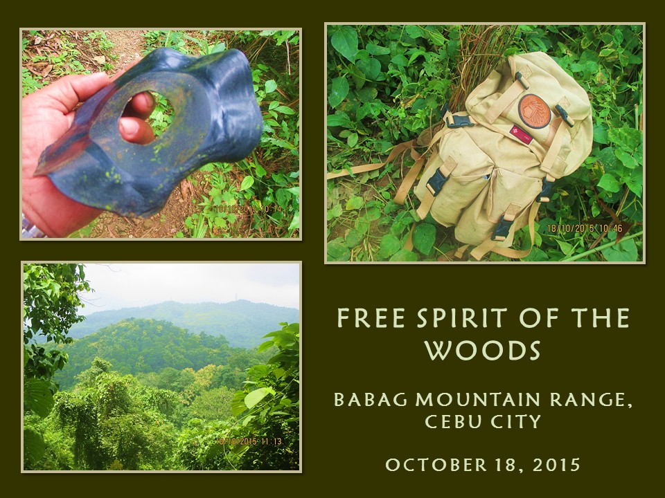
one is with you. Come on, use your imagination. I picked up a warped old 45 polyvinyl disc and keep it in my bag after I have finished my nature call.

I met a local with a heavy sack over his head and I gave the privilege of the trail to him. Despite gaining little in his progress by the heavy weight, the man took time to ask me why I am alone today? I answered him honestly and he went on his way grinning. I saw a woman splitting firewood with a bolo from a distance and she smiled when I gave her morning greetings. I talked to another local with a sack of coconuts over his head and asking me the same question. He gave his name as Ronald.


I reach the place called the Portal at 10:45 and I savor my first sips of my water. Meanwhile, my mind is working which of the seven routes would I take. I chose one that goes deep into jungle which leads to a stream. The trail is beginning to vanish as the vegetation claimed the bare grounds. Some parts have been washed away by water making my walk quite dangerous. The Merrells never failed me here but my sense of balance begins to irritate me.

It could be caused by different factors: 1) Lack of breakfast, 2) overweight or a 3) shifting backpack. I considered all three but I suspect the bag. It is overloaded by useless weights and the insides shift when I move. The bag is of old-school design and does not have a waist belt to hold the bag still. I use my hands when I need to as I weave along a tiny ribbon of ground which sometimes went missing for a time.

The last time I passed by here was in December 2014. That time I was leading people into the streams but the path that provided me through there had been missing or that the vegetation had really gobbled it up for good. I am now in a quandary if the other trail that would lead to Starbucks Hill would not be found also. I changed plans and take another trail but it led me to a familiar hill and to a community which I want to sidestep at.

I am back to square one and I start from there to Creek Alpha instead. A great transformation from the original plan. Reaching the community took a lot of my energy which no bread could compensate. I can now feel the burning hunger. I can never discipline a brain that automatically sends signal from the stomach. Well, it can wait for I intend to go slow to keep the mind from dictating its wishes on me.

I reach Creek Alpha at my own pace at 12:25 and I would go downstream to where a trail would lead me to another stream. The water is clear and briskly running in the fulness of its existence in a rainy season. Ahead are footprints of children and adult alike, distinguishable by bare and sandaled feet on sand. My senses peaked up a notch upon learning of people ahead of me. The sensation of hunger is now totally gone.

Meanwhile, my close observations on plants have led me to an exposed rootcrop of an Asiatic bitter yam (Local name: kobong) and I plucked a piece intending to propagate it on my backyard. The thorny vines make a good obstacle for burglars and strays. As I proceed on, I saw a small stream that connects to the bigger Creek Alpha. It looks good even if going above it takes a little climbing. I found a small pool and, above it, more climbing.


I go back to the main stream and found the trail. I reach Creek Bravo at 13:20 and take a short rest. I see the groves of water bamboos (botong) above me are recovering from its desecration of two years ago and, I believe, a single pole is ripe for the taking for another bushcraft camp should I host it back here. I take another trail bound for Camp Damazo taking dry twigs for firewood along the way. I may have to boil water at the campsite to dump the contents of my only sachet of coffee into it.

I reach the camp at 14:20 and begin a fire between a trio of stones. Camp Damazo is still the best place to do these trainings for the ladies, even of the auditions itself, because it has a clean source of water nearby. Likewise, it could now host another episode of the Philippine Independence Bushcraft Camp since the vegetation had already stabilized. It could host more people this time since there is a wide level ground a few meters away from camp.

After I had my coffee, I continue my hike at 15:20. The natural spring which had provided the camp with reliable water had become a small stream. Strong rains had caused the enlargement of the hole and washed away the bamboo trough that I had placed there in 2013. Its source came from another stream some 300 meters away, which I called Creek Charlie, whose water passes through permeable rock, sand and clay.

I push on and cross two more small streams, the upper parts of Alpha and Bravo, and climb up a steep trail that passes by healthy stands of stinging trees (alingatong) beside a stream. I reach Baksan Road and cross it to view a firewood gatherer’s version of a Nessmuk triumvirate. It is a heavy US-made axehead with a thick GI pipe for a haft; a local blade – 20 inches long – whose handle is bound by strips of rubber; and a stainless kitchen knife whose blade had metamorphosed into a mere sliver due to constant sharpening.

I take an easy stroll down to Lanipao enjoying the full bloom of the plants until I reach it at 16:50 and down some more to Napo which I found at 17:30. I got a motorcycle ride back to Guadalupe and changed to dry clothes while at the parking area of the Catholic church. I spend the rest of my day for a couple of cold San Miguel Beer bottles at a watering hole frequented by expats. Cheers! Mission accomplished.


Document done in LibreOffice 3.4 Writer

Friday, July 1, 2016

NAPO TO BABAG TALES CV: Woodlore

WHEN YOU ARE WITH the Camp Red Bushcraft and Survival Guild, everything is interesting on any given Sunday.  Their saga continues on and they could go anywhere they wished to and indulge in their favorite past time, which they called as “dirt time”. They love to work with their blades to make survival tools, to prepare their meals and to talk about its qualities which is just about infinite.  Then they cook feasts, which is the best part of their day.

Coming with them for the fourth time straight is the Colonel himself – Thomas Moore. Pathfinder Tom is one of the stars of the high-rating Discovery Channel survival TV show, Dude You’re Screwed, which was shown in Asia as Survive That. He is in Cebu to organize the team for Expedition Philippines, another survival reality show that he is planning to direct and participate in in one of the eight episodes.


I am with them today, October 11, 2015.  We all wished to spend the day at Camp Xi, a nice piece of flat land beside the meandering Sapangdaku Creek, which is perfect for big outdoor activities. After securing our food ingredients at Guadalupe, we proceed to Napo and walk the short distance to Camp Xi.  Jhurds Neo is leading the guys, totally comfortable on the idea of a happy walk and a very enjoyable day.

Coming along are Ernie Salomon, Aljew Frasco, Bona Canga, Jonathan Apurado, Justin Apurado, Locel Navarro, Christopher Ngosiok, Angel Villaganas, Niño Paul Beriales, Nelson Tan, Cleos Navarro and the Quijano Family of Richie, Francelyn and 7-year old Legend. With us, as guests, are Peter Tortusa and his Japanese lady friend, Kaoru. They all would be glad to spend the day with Pathfinder Tom.

We will spend another Sunday cooking up another feast.  All unsheathed their blades and begins the process of extracting useful firewood from debris.  A spark from a ferro rod gives life to a fire and water is boiled, presumably for coffee. Coffee. Oh, coffee. Where art thou? It came in a short while.  Why would people disdain coffee? Do they not know what it gives to a thirsty bushman?  A ton of inspiration.


With my William Rodgers bushcraft knife, I go down the river bank and look for bananas. No, I am not looking for the fruit or its blooming heart but I need the trunk for food. I rejoin the rest when I have a banana trunk with me, all quite perplexed when they learned that I am going to cook it.  They watch and they ask a lot of questions which is good because bushcraft cannot progress if your curiosity is confined to your eyes only.

Meanwhile, others proceed on to what they do best. Ernie has his grub wagon open and Jonathan is a willing subaltern. Angel and Locel blow some life into a fledgling flame for what I believe a grill session.  Aljew kept those coffee in good stead with his improvised billy can suspended by a tripod.  Francelyn just fried an amorous mix of spices on a small pot.  Christopher is everywhere, clicking on the shutter of his camera as if it is an assault rifle. Click click...click click.

Tom and Jhurds joins Aljew and Bona in a little chit chat.  Somebody just got mentioned and laughter roared as if a gang of hyena suddenly got transported from the Okuvango and wandered here. Peter watch the separate actions and unleashed his knife to make the best of the moment while Kaoru is in a daze, witnessing a new experience. A little while she begins to blend in by throwing a few pebbles to a faraway target with a slingshot.


Oh, I forgot about little Legend. He is watching his dad making a bamboo bow and arrow. Cleos and Justin are also in that observation platform.  When it was done, Legend begins to shoot at imaginary targets.  Her mother, meanwhile, is cooking soup from a dehydrated kelp which immediately got Kaoru’s attention.  Cultural gaps are better bridged by food and, once the connection is established, understanding and pleasant conversations follow.

Lunchtime ultimately came and the food is served. Ernie had cooked a local pasta (Local: pansit bihon) which he paired with pickled raw cucumber. The rice is neatly spread on frayed banana leaves to imitate a popular military style of meal, the “boodle fight”. Grilled pork are placed above the rice.  Seaweed soup is in its pot while my banana core adobo is in another. Game time!

After the meal, I organize all the ladies into one group and tour them around Camp Xi for a lecture of plant identification. This is in response to Tom who sees a need to involve a contemporary Filipina in one of the episodes of EP.  There will be auditions for that slot and, before that, I will train prospective lady applicants into advanced wilderness skills and that includes a plant ID tour.


What I am doing is just an eye opener since not all qualify as an applicant for they lacked the basic training in bushcraft and survival which is a prerequisite.  The show do not need actors but real bushcraft and survival practitioners.  We approach a colony of taros. There are purple taros, white taros, giant taros and giant wild taros. From among these, there are edibles and there are the toxic ones.  Identifying which from which is mind boggling since they almost look the same.

We transfer to a bunch of bananas.  I point to them the edible parts like the blossom and the fruit. I also reminded them of the trunk which I just cooked which came from here. On a stump of banana which I just cut, I carved a hole in the middle and, a few minutes after, water slowly filled the cavity.  They looked at the blade of my AJF Gahum which have stained after contact with the banana.  Do not worry. It is called a patina. It is good for the blade.

We cross the stream and climb up a path to another level ground.  I look around and I tow them to a tree which bear several strings of round green fruits.  That is a lanzones. Unbelief. I pluck a yellowish one and opened the skin.  Lanzones.  I eat a part and pass the rest to the ladies.  LANZONES! And they wanted more. I climb the tree and found a few half-ripe fruit which the ladies gorge among themselves.


I move to a thick growth of birds-of-paradise.  Too dangerous to be near.  We do not know what is behind that thick curtain of stems which have grown so close to each other, but I know there is water and, where there is water, there could be a predator or there could be food.  I stood on a rock and gaze down below.  Some ferns grow and another smaller fern variety which is very familiar because it is edible (Local name: paku) is also in this mix-up.

We cross the stream again and the guys are waiting for us.  It is now 14:10 and just about right to pack our things and go back the way we have started in the morning. Just about right, is it? How about the part that ends all activities?  The knife porn? Indeed, all the blades has its 15 minutes of fame.  A log becomes home to some of the blades but it ran out of space, necessitating for another log to accept more blades. Very impressive!

At 15:00, we leave Camp Xi for Napo and, from there, for Guadalupe and to Red Hours. Tom and I opt for big bottles of the coldest San Miguel Pale Pilsen to ourselves without drinking glasses. The rest choose to drink it with glasses. It was a fine occassion to toast good health and fortune to little Woodlore, the newly-born son of Nelson, who arrive with her mother.  Tom carried Woody in his arms and the little guy did not let out a whimper.

To good health and fortune Woodlore!


Document done in LibreOffice 4.4 Writer