Showing posts with label Asturias. Show all posts

Sunday, November 21, 2021

2021-045 | ADRENALINE ADVENTURE HIKE: SEGMENT IV-A

SEGMENT IV OF THE CEBU Highlands Trail is the beginning of where leisure mountain camping ends. The latter had been popular, especially at its two prominent peaks: Mt. Manunggal and Mt. Mauyog. These had been shaped by constant activities of outdoor clubs beginning in the ‘80s. What lies beyond is terra incognita or “no man’s land”. 

I decided to break that impasse by boldly walking through those areas in October 2015 with which places have confined the activities and stunted the growth of the collective outdoor community only on those two peaks because it was risky to do so. That exploration opened a corridor of passage where I eventually used during my Thruhike in January to February 2017.

Segment IV is divided into two sub-segments because of its length: Segment IV-A starts from Mt. Manunggal, Balamban and ends in Lawaan, Danao City. Segment IV-B takes off from Lawaan and finishes at Caurasan, Carmen. These were the very places which were frequented by armed groups in the ‘80s up to the earliest years of the third millennium. 

But Gian Carlo and Sheila Mei of Team Adrenaline Romance were ready. They understood that mindset which only long trails could provide. They honed this, starting from Mt. Manunggal to Mantalongon, Dalaguete, churning a mileage of 166.56 kilometers on four sets of weekends for Segment I, II and III. It was beyond my expectations considering that segment hiking the CHT was still an experiment yet. 

Experiment, in the sense, that I could not choose the people who desires to walk the CHT’s rugged length, the tyranny of the humid tropical climate, the remoteness from help and the very inquisitive locals. There was one major adjustment that I had made in the light of these and this was the deliberate reduction of pace. I cannot afford accidents in the middle of nowhere. I had to have a modicum of control on people’s movements, especially at places where you cannot observe them. Then, of course, there is the radio.

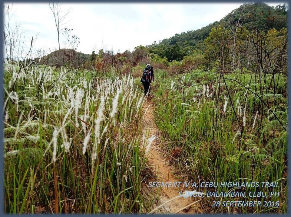
So the paths to the north of Mt. Manunggal were ripe for the taking on that day of September 29, 2018 and Team Adrenaline Romance were in the right place, at the right time, with the right person leading them to places where only a handful had been. Going with them were Apol and Swiss adventurer, Markus. This was the very first time that adventure tourism would be exposed on these misunderstood places. 

After a meet-up at the Ayala Mall van-for-hire terminal at 05:00, we cruised over the Transcentral Highway in a passenger van and to our preferred starting point, on a lonely corner where a feeder road led to Mt. Manunggal. On this very spot, Team Adrenaline Romance launched their campaign of the CHT seven months ago, which was the first half of Segment I. It was an extraordinary feeling for everyone who were here. 

We transferred by motorcycles-for-hire to the campgrounds of Mt. Manunggal and proceed to acquire something to eat for we simply forgot to eat breakfast, except for Markus. Then the journey for Segment IV lurched under a controlled pace at 07:15. The weather was mild but, once out of the mantle of fogs, it would be humid out there. We followed the route I explored in 2015 and it remained wild.


The forest had reclaimed what was theirs after a road was created in their midst. On a trail in between tall grasses, I spotted a large bird scat. It was made by a mature grass owl, perhaps a pregnant female. This was her breeding ground. Trees abound on both sides, 20 meters away and, ahead, were wild raspberries (Local: sampinit) which branches were heavy with succulent fruits. 

The path narrowed as we passed through it, plucking as many raspberries as we could and enjoying the freedom of the hills. We delighted the solitude of the moment, for we know, in five years’ time, people would come to settle and claim farm patches here. That would be alright if you are a subsistence farmer but what I feared really are outsiders who would buy rights to big chunks of land and then fence off both humans and beasts away in the name of “development”. 

I saw a couple of homesteads along the way but I know also that the lure of money from these outsiders would make them exchange their way of life for the lowlands, forfeiting their children’s rights to the land and its bounties. It is a cycle as moneyed lowlanders from the cities purchase properties to do “farming” while the true farmers on the mountains sold those rights to make a living in the urban areas. Then they exchange places, maybe in a hundred years. 

After snaking our way through that beautiful forest, we were met by wide open spaces – Cebu’s “Big Sky” – where you could see beyond the highlands rolling north before you without any obstacle. We stopped here for a while to rest and rehydrate. Markus carried with him binoculars and I saw better with a larga vista than with my own naked eyes.

With magnified vision, I noted Garces Peak of Asturias, Mt. Kalabasa and Mt. Mago of Danao, Ngipon sa Ilaga of Carmen and Mt. Kapayas of Catmon. Beyond was a blur of blue. All of these are on the fringes of Segment IV. These might be very far from where we stood but, in a matter of a day, we would be below Mt. Kalabasa. Another 2-and-a-half days, Mt. Kapayas. Team Adrenaline Romance have used my assessments to gauge their strength, stamina and rest time since day one of their journey. 

If Markus had brought a binocular, he would be bringing other items as well. While a binocular is a valued item, it is not a necessity on this long trail. He has a backpack with him and another big sling bag made of canvass. He answered to my appeal in bringing a gift for the grandchildren of Candelario Garces, who lived on a very remote mountain of Kaluwangan, Asturias. It was a board game and I decided to remove the burden from him and carry it myself.

We all carried extra loads for the Garces grandchildren. We would unload that tomorrow and we need to reach Cabasiangan first for the day was getting warmer. Tech1 Corporation, distributor of VERSA 2-Way Radios, loaned me a pair of their VERSA QuickTalk Go, for field tests. It is in FRS/UHF band which is ideal for urban areas with transmission distances of up to 200 meters but equally effective where there were no obstacles like unpaved mountain roads. I let Gian Carlo carry one of the pair. 

This heavily-furrowed road brought us to a small community which has a small store that sells cold soda drinks. They did not have something cold, this time, since a ref conked out. What the place had was a wounded, leopard cat (maral). It was breathing heavily half-alive and I cannot understand why people here did not put it out of its misery. Pity aside, it was my first time to see it so close, although I saw glimpses of this many times on the mountains. 

Leaving that poor animal, we decided to move on. We took a short cut but the imperious sun was still bearing its heat to our exposed skin no matter how we tried to be smart. As I was with Apol, a hundred meters away from the village center of Cabasiangan and waiting for them, my VERSA QuickTalk Go caught a transmission from Gian Carlo. I left my bag with Apol and proceed to their location. 

It was very warm at 11:15 yet I overtook a male local and appealed to him to carry a bag of one companion who may have been bogged down by the severe warmth. After a few minutes, Gian Carlo, Sheila Mei and Markus emerged with the local carrying a backpack. We thanked the local and paid him for his valuable services and we all decided to enjoy our noonbreak under the shade of a covered basketball court. 

At 13:30, we left Cabasiangan but not after ensuring that Markus gets a motorcycle ride down the lowlands and safety. The tropical heat was just too much for him. When we continued our journey, it was really warm. No amount of breeze could stymie the heat. We rest when we find a shady spot where there were no houses. We city people have habits, ways of talking and body language which locals might find unusual and might gave off a different connotation if espied.


We arrived at the village center of Ginatilan and, fortunately for us, their village chairwoman was present and I personally asked her approval to let us stay for the night at their old village square found at the bottom of this mountain where it meets the Lusaran River. It was downhill walk but, at least, it hid us from the overpowering heat of the mid-afternoon. At 16:00, we arrived there and claimed their granary as our billet area. 

On the second day, September 30, we left Ginatilan to cross the Lusaran River at 07:45. The water was just right as against the last time where it was thigh level. Everyone crossed the stream safely to the other side, which became the Municipality of Asturias. On the higher bank was a community square and a public school. 

Seen a familiar face. It was the farmer whom I talked to during my 2017 Thruhike. He was the son of a Korean War veteran and currently employed as a sentry in the said school. I gave him my extra Swiss Army Knife as my token of friendship and as my gesture to establish rapport in this place, as I did so on other places.  

Of course I printed certificates of appreciation for those villages which welcomed me during the CHT route explorations and the Thruhike. In Segment I, it was the village of Buot, Cebu City. In Segment II: Tubod, San Fernando. In Segment III: Mantalongon, Barili; Mompeller and Balaas, Argao; and Mantalongon, Dalaguete. Here, in Segment IV-A, I already gave Ginatilan. 

Soon, I would provide a different appreciation of thanks to Candelario Garces and his wife for welcoming me during the October 2014 exploration and for sharing what little food they had during the Thruhike where I passed by here last February 2, 2017. We have gifts for the Garces couple and their grandchildren. Yes, we have extra cargo but it would be worth its weight in bringing it here. 

I followed the trail up a ridge. It was another very warm day but I have one person less to look after this time. The view from up here was superb and you could see the serpentine path of the Lusaran River below, shining as the sun reflected its surface. I struggled with my breathing under the naked sun until I reached a forest line and stopped to rest, leaning my weight on a live tree. The canvass sling bag with its cargo were both heavy. 

After a few minutes of catching my breath, the covered trail led to a high meadow where there were two children playing. Instantly, the kids recognized me and respectfully took my hand to kiss it. The kids, a boy and a girl, were very happy and laughing to see visitors. They led us to their remote home. We finally arrived at the Garces Homestead at 09:40 and unloaded our gifts.

There was the expensive boardgame bought by Markus which I carried on his behalf. Gian Carlo and Sheila Mei unpacked their bags to produce two loaves of sliced bread, chocolates and more food. Apol has notebooks, pencils, ballpens, crayons and writing pads. On my part, I brought two books, four paracord bracelet assembly kits and free giveaways from a popular fastfood chain.

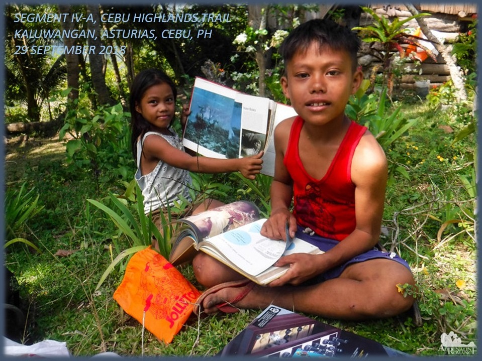
Apol was most helpful with her experience in dealing with children, orphans and youths in conflict with the law. She made the children overcome their shyness and sang and played with her. She even taught them how to create a paracord bracelet from the assembly kits. We gave all the food we brought to the beaming grandparents.

After an hour of rest and interaction with the two children, we bade goodbye and proceed on our journey to finish this sub segment. We were feeling blessed to impart something which would be appreciated very well by them as well as to their grandparents. It was a nice feeling and the hour-long rest was well deserved for the four of us. 

So I followed the rest of the trail through the graces of a kind memory. Sometimes I missed a path but most of the time I was correct. If I was in doubt, I brought out my compass for the cardinal directions. If it could not help me, I consult my map but it rarely came to that. Navigating in an almost unfamiliar terrain by memory sometimes burn you out.

When I missed a trail, I retraced my path until I found a familiar something. It could be a landmark, a familiar smell or just a gut feeling. But a chance meeting with a local is most valued. So I found the true path on the premise of the familiar and I found the unnamed river that separates Asturias from Danao City. It is a long descent and somewhere up ahead would be the pot of gold. 

We reached the bottom and prepared our lunch at a time. We are behind schedule. It was already 13:00. While Gian Carlo was at it, Apol and Sheila Mei took a dip on a deep pool of a stream where there was a small waterfall. God, it was so warm. I keep Gian Carlo company and exchanged stories to keep us occupied on dry ground. It was a good moment under the shade, recouping strength with coffee even on a very warm day! 

After a more than an hour of noonbreak, we crossed the stream and were now in Danao City. A path led to a large tree where there was a bull blocking the way. Although it was leashed, it could still reach us should we took any of the safest spaces to walk. The best thing to do is walk as one tight group so as to intimidate or confuse him. Small fries do that to keep at bay bigger fishes. 

There was a community and we moved through it and over a steep hillside which was bare and loose. Then we crossed a smaller stream and we were now in the village of Sacsac. We reached a paved road and stopped at a store to hydrate with cold RC Cola, just like I did during my thruhike here. For a good 15 minutes we took our rest ignoring a huge but empty jeepney calling out for passengers. We disregarded the opportunity, afraid that it may stay longer and ruin our itinerary. 

By 15:20, we moved out, following the ascending road that offered a view of the imposing karst formation and forest that was visible from yesterday’s walk. At the steepest part of the road, the empty jeepney roared ahead of us on its way to the Danao City terminal. Pride kept us grounded afraid to cheat for just a while. Anyway, after an hour of walking up several rises which seemed to have no end, we arrived the main road at Lawaan. 

We made it at 16:45 but, at this hour, in these places, transportation were scarce. After a longer wait, we were able to convince two motorcycle-for-hire drivers to ferry us down to the city center. Although downhill, the distance was great and we arrived 30 minutes later. We transferred to midget public jeepneys, dropping by at Liloan, to grace the opening of a friend’s halo-halo franchise and ingratiate ourselves with the specialty of the house to recover lost energies.

Team Adrenaline Romance, after Segment IV-A, have amassed a total of 190.05 kilometers and there is the Segment IV-B that is scheduled for October 13-14, 2018, which would surely goad them over the 200-kilometer mark and complete the first half of the CHT. That was a tough walk and the trail north has lots of these. But Team Adrenaline Romance is now in the groove of things of how the CHT ought to be walked…and enjoyed.  

Gian Carlo and Sheila Mei wrote about their Segment IV-A experience on the Adrenaline Romance Blog under two installments: 

Cebu Highlands Trail Segment IV-A: Mt. Manunggal to Ginatilan, Balamban.

Cebu Highlands Trail Segment IV-A: Ginatilan to Lawaan, Danao.

Wednesday, July 26, 2017

THE THRUHIKE JOURNAL: Day 15 (Ginatilan to Lawaan)

IT WAS COLD LAST NIGHT. Breeze kept blowing through the iron grills that is part of the wall of the storage house where we slept in. This community in Ginatilan, Balamban begins to stir to life in the early morning. Today is February 2, 2017 and, any hour from now, we will start Day Fifteen of our Thruhike. Coffee smells good as I stirred its powdery contents into hot water. Jonathaniel Apurado, as usual, cooks the rice and Knorr soup which begins to lose its appetizing mien on me. Capsules of multivitamins and natural raw Guarana completes our breakfast.

Residents came to know more about us after studying our vinyl banner tied on to the storage house announcing our activity. Located in the most remote part of Balamban, this community is nestled deep in the valley but is now accessible by a newly opened road. It once was the center of the village and engaged in commerce directly with Cebu City through the unpredictable Lusaran River until they transferred the seat of governance up a hill for better accessibility. The name of Ginatilan, I suspect, came from the Cebuano word “kinati-ilan”, meaning “at the lowest spot”.


Deprived of a bath for three days, I am still fresh and comfortable. A good night’s sleep sure helped a lot. The blisters on my feet are now history. The Hi-Tec Lima shoes mothered the affected part well. I have changed into a fresh pair of Kailas socks as well as a fresh pair of Accel elastic undershorts. The load inside my High Sierra Titan backpack is getting lighter and it helped a bit as we still have rugged terrain to hike up and down to.

Although I have explored these places in 2015, I cannot assure myself that I would be walking on the same trails again. I did not explore it with the benefit of a modern gadget like a GPS. I did it with dead reckoning most of the time and only once did I use a map and compass to check on my location when I found the website-sourced maps completely inaccurate when it came to placing names. A GPS transmitter is provided in this Thruhike by Galileo Satellite Control System Philippines so it could track our progress and save these in a cloud environment.

Right now, I will be walking on sheer memory, the product of the oddities of traditional navigation. After saying our thanks and bidding farewell at 08:10, we follow an unpaved road that goes down to the banks of the Lusaran River. This river is the second biggest river system in the island of Cebu. It has many headwaters, some of whom cascade down as barriers between local government units like between Cebu City and Balamban and Asturias.


The water level is at thigh level at its middle while current is moderate but it could carry you far downstream if you lose balance. Saw two boys ahead of us nimbly tiptoeing on concrete footpaths but once they were on water, they know where to place foot. I followed where they stepped at and I went easy on the other side. Jon struggled midstream as he failed to study the boys and almost tumbled over. He reached on the pebbly shore safely.

We stayed for a while to dry our feet. A man came over asking a question which turned into a conversation. He is a typical farmer, unkempt and unassuming, but beneath that rugged veneer, he is none other than the legal son of the late Sgt. Dionisio Calvo Rojas of the former 38th PC Company. It may not ring a bell to you but his father saw action in the Korean War as a member of the 10th Battalion Combat Team and came back home alive. He is the son of a hero and I reach out my hand as my sign of respect and shook his.

Our BCTs sent to Korea under the command of the United Nations did our country proud. I came to know them when I had the privilege of listening to three veterans talking among themselves many years ago. Your pride would swell when you learned how these guys from the 10th, the 14th and the 18th would stand on their ground on the trenches when other UN units abandoned theirs in the face of overwhelming odds, even in the dead of winter.

They would inflict heavy casualties against the North Koreans and the Chinese in close combat warfare. It simply is amazing since we do not have winter here and I could not imagine how our guys adapt quickly to that semi-arctic environment they are in but, they said, they learned painful lessons when they failed to wear mittens while touching metallic objects such as a spoon or a trigger. Chocolates, thick trench coats and PX goods made their life better there and raised their morale.


His is a sad tale though. His father remarried and sired many sons from other women. Deprived of support, he was forced to stop his studies and worked on odd jobs which took him to even as far as Hacienda Luisita in Tarlac. His mother is still alive, old and frail, and he needs help so her mother could avail of the survivor’s pension due her as the legal wife of a veteran. Here, in the most remote part of Cebu, of all places, I met the son of a hero.

The tale he spoke about his father’s service to country and the sad chapter after that moved me to put it in print here. As I have posted before, the CHT is not just about ecstasy of landscapes and adrenaline rushes, it is about people. People who have tales to tell. People who are hungry of news of the world beyond their places. People who are positive of improving their lives and grounded on their faith that someday they will be delivered from poverty.

We are now in the side of Asturias town. This is their farthest and their most remote part. We are in the village of Kaluwangan II. After crossing another stream, I am on to drier ground. There is a path and there is a school nearby. I pursue the trail up a mountain. It is always ascending and I looked back and relished at the beauty of the Lusaran River as seen from my vantage point. The river bent along the foothills creating deep pools almost oxbow-lake like.

I am not following the old path that I took two years ago but is in the midst of a new one where I thought would bring me direct to Uling Ridge. This is a small mountain range but it is formidable just the same. Not far away would be the Garces Homestead. I am told that today is the birthday of Candelario Garces and so have prepared something modest for him, his wife and his grandchildren. Actually, it is just surplus food that I carried for emergencies. Anyway, we will get a resupply once we reach Lawaan, Danao City.


The trail I am following goes into a cassava plot which was recently harvested, depriving us of handholds for balance. On the other side is the sheer drop of a steep slope without any vegetation to stop a roll. A careless slip would send you down tumbling a long ways. When you are into these situations, your senses and attention peaked a notch and you went carefully. The trail passes by a very small community of three houses. At this point, I sent a text message to the Asturias Police Station informing them if our presence.

Candelario is there and I greet him a happy birthday. He smiled but he seems to be sad. He is mourning the death of a grandson who was murdered in Cabasiangan, Balamban a month ago. I was saddened at the news since his late grandson was just a boy, still in his teens. Who would do such bad things to a teenager? These places we are trodding upon is still a semi-lawless region where scores are settled in violence. I gave him my gifts. In return, we refilled our water bottles.

He is alone as his wife is out there in the fields tending their farm plots while his other grandchildren are in school. His house is located near the peak. I was wondering if there is a name given for that peak? If there is none, then I will exercise my privilege of giving it a name being the first outdoorsman who explored this area. Why not Garces Peak? I dare say it is quite appropriate, is it not?

From here, I propagated VHF signals for the direction of the Babag Mountain Range in Cebu City, but it failed. Instead, I redirect my transmission to the coastline and I got a reply this time from an amateur radio station, 4F7MHZ. What amuses me is that I sent it in simplex VHF and the remote station received my signals in duplex UHF. I just cannot explain why? By the way, I am using and testing a Versa Duo VHF transceiver, at 5 watts power, loaned to me by Tech1 Corporation.


Before leaving, Candelario parted some of his prepared food for his birthday to us. These are two pieces from the free-rein chicken cooked in estofado and wrapped inside a small plastic that used to store cookies. How touching. My heart wept at his kind gesture. He has less in life but he still gave. He is an old man and frail. He goes to his farm on a horse because his lungs cannot endure walking on even moderate distances. He suffered incarceration in the past by a miscarriage of justice but that is another story.

We go down Garces Peak into a long route that passes by into more remote places. Unbelievably, a small house exists here and, further on, a bigger house where there is a woman weaving natural fibers on an ancient loom. We cross a small stream and debated on which route we would take when we faced a fork on a trail. I opt the more beaten one and I was rewarded by my guess when I met a mother and her son going home to Ginatilan from Danao City.

My eyes now fixed on the trail and on the landmarks ahead, it was not difficult anymore. We come upon a ridge overlooking a stream. On the other side would be Danao City and there is an activity on the stream. Under the shade of Mexican lilac trees, I watched the stream while munching on our noontime specialty of Nutribar and our trail food mix of peanuts, coated chocolates, marshmallows and raisins. Water does the rest of bloating it. Popped in another Guarana extract and then I chased sleep in humid temperatures.


We go down the mountain and into the bank of a stream. A father and his son are catching fish by hand using stones and barriers to trap these in small pools. Ingenious. So bushcrafty. So much to my liking. I practice bushcraft and championed this as a better outdoors activity over those that imitate Western culture or that relies so much on expensive gear, clothing and equipment. Bushcraft is a realistic activity that fits well in austere environments like mountains and jungles.

We cross this unnamed stream that drains into the bigger Lusaran River on the map. It is smaller but it is wilder and so was harder to walk across. There is a dangerous trail over on the other side, whose surface had been gnawed away by water, undermining rocks to precarious situations. Once we got past it, the path goes up and up. It is very warm. I do not know why, perhaps, there might be rain later. I see an electric post on top of a hill and it becomes my reference. Perhaps too, there might be a road or a community.

There is a house and another one and a good trail over the side of a hill and, ultimately, a paved road. On one side of this road is the village of Sacsac, Danao City, while on the other side would be Lawaan. We stop by a small store to rehydrate. There are cold bottles of RC Cola and I opened it with my Victorinox Ranger. It is good to just sit down and enjoy the shaded bamboo bench after a hard day of walking on rugged terrain. The rest allowed me to inform the Danao City Police Station of our activity.

The route we took is the same one used by residents of Ginatilan pushing their farm produce to the markets of Danao City and bringing home their weekly needs. Thankfully, our loads are light now as we used up most of our food and fuel. The concrete hardtop is unkind to feet as it goes on its rolling progress. We finally reach the edge of the village of Lawaan, passing by a school then the San Isidro Labrador Parish and, finally, the village hall at 15:35.


Village officials led by Hon. Pilarino Monte and Hon. Shirley Ramos, welcomed us to Lawaan and ushered us to our billeting place. After 15 minutes, our supply team arrived early on board the Toyota Hilux pickup driven by Swiss Markus Immer. Coming with him are Ernie Salomon, the couple Mark and Mirasol Lepon, Aaron Binoya and Justin Apurado. They got lots of Park N Go bread and baked products and 20 bottles Yakult Cultured Milk.

The people of Lawaan treated us all to a dinner of free-rein chicken soup and we were so much indebted to their kind gesture. They have given the upper floor of their village hall for our use. Markus and the rest left us when the rains fell, but Justin and the Lepon couple stayed. They would walk with us starting tomorrow to as far as to where their vacant schedules allow. Indeed. Tomorrow would be another hard day but it would be a very complicated trail, slippery and dangerous.

Distance Walked: 8.35 kilometers
Elevation Gained: 554 meters and a low of 107 meters


Document done in LibreOffice 5.2 Writer

Friday, July 15, 2016

MAN-SIZED HIKE XVI: Gaas to Danasan

AFTER ACCOMPLISHING FIFTY PERCENT of the CEBU HIGHLANDS TRAIL PROJECT last May 2015, the Exploration Team prepares to tackle the second half by taking on the first of the last four parts, which is Segment IV. The route that Segment IV will follow, will be from Mount Manunggal, Balamban, flowing north to Caurasan, Carmen. It will pass by the mountain ranges of Cebu's Midnorth Area and would be one of the hardest yet of the eight segments allotted to the Cebu Highlands Trail Project.

The CEBU HIGHLANDS TRAIL PROJECT is a personal undertaking that had has as its beginnings from the passion of hiking and camping among mountains. I realized that the island of Cebu can be walked along its most rugged spine from north to south or reverse. It only takes a steely determination to achieve this to offset what I lacked in funds and sponsors. Later on, people began to appreciate how this project will benefit Cebu and its people. Patterned after the Appalachian Trail and the Pacific Crest Trail of the USA, it will be an attraction soon for foreign and local tourists when completed.


The Exploration Team that I organized is not at its peak for Segment IV and I have only Justin Apurado to accompany me. I do not know how we both would achieve Segment IV but we will follow things according to plan. We will be on a wide stretch of country where, many years ago – and still is – considered too dangerous for mainstream outdoor activities. We do not have the benefit of a guide nor of a local who may well act as liaison. This would be exploration at its best, travelling by traditional means, aided only by a compass and by printed versions of small maps from a website.

I am pressuring myself to end the exploration phase of this ambitious project in 2016 and make the CEBU HIGHLANDS TRAIL available to the public by 2017. I have done this almost singlehandedly and I am determined to finish this to the end even if I am left with rags to wear. What you do not know is that I will leave a legacy of dots in a box – a template – so others who will follow after me would refine the CEBU HIGHLANDS TRAIL into a first-class long trail that would attract international backpackers and encourage local ones to enjoy their own mountains.

Today, October 22, 2015, is the day when Segment IV will finally be walked through. I and Justin had prepared well our stamina, including the basic items that the Team needs. This Team, to include reserves Jonathan Apurado and Jovahn Ybañez, is better prepared and organized than the previous ones I had led so there would be no more waste of time. The sacrifices and preparations during our training had worked so well during Segment III and Segment V where the Team had shaved a day each from its original schedules.

I will lead again my Team into places where many mainstream outdoors people have not been into before. There is more to Cebu and adventure can be most enjoyed here horizontally instead of vertical ascents. This is a four-day hike that will start from the Transcentral Highway in Balamban and, hopefully, would end at Carmen. I will follow a hypothetical route that will surely pass into Danao City and Carmen and, probably, might stray into either Cebu City, Asturias, Compostela or maybe in Tuburan.

After waking up at 04:00, I walk out of my house an hour later to the old Compania Maritima, across the Cebu City Hall, which has been converted into a terminal for passenger vans for hire, and waited for Justin. Confused with their travel schedules, we transferred to another terminal at the Cebu Business Park where we were able to depart at around 06:40.

As in every organized explorations, there is the Base Support Team. It will monitor our progress and will give weather updates to us and then informs the outdoors community in Facebook. Chad Bacolod, a fine communicator from Ham Radio Cebu, will man the desk. We will “ride” on the frequency of the Central Cebu Rescue Emergency Team (CCRET) of Danao City. Another crew, Jhurds Neo, of the Camp Red and Bushcraft and Survival Guild, will be alternate on communications and would be mobilized when in emergencies.

This Team, will carry a banner that describes our activity as well as the logos and names of sponsors. These are GV Hotels, Silangan Outdoor Equipment, Titay’s Lilo-an Rosquillos and Native Delicacies, Tactical Security Agency, Jonathan Blanes, Glen Domingo, Alan Poole, Alvin John Osmeña, Aljew Frasco, Boy Toledo and Glenn Pestaño. Also included are entities who contribute to the Team by other means like Camp Red, Mountain Climbers Alliance of the Philippines, Ham Radio Cebu, Drinox's Kitchen, Quijano Family, PAC Outdoor Gear, the Philippine Mountaineering Blog and the Warrior Pilgrimage Blog.

We are proudly wearing the team uniform jerseys provided for by Silangan with the name of the CEBU HIGHLANDS TRAIL PROJECT emblazoned on the front. Silangan Outdoor Equipment is my official outfitter since I endorse their products through my Warrior Pilgrimage Blog and in fora where the outdoors community interact. I am wearing their Greyman Hiking Pants and are bringing also their blue-colored side pouch and their second generation hammock. Likewise, I will be using a new pair of Merrell Geomorph hike shoes that Mr. Frasco had provided me.

Aside that, the CEBU HIGHLANDS TRAIL PROJECT is officially sanctioned by the Cebu Provincial Government as a legitimate outdoor activity that would help them identify places where adventure tourism would be developed on the remote mountain areas of the island. This, after my meeting with the Honorable Grecilda Sanchez, board member representing the Third District, and Ms. Mary Grace Paulino, the provincial tourism officer.

The following are the narrative of events in chronological order that tell the whole picture of SEGMENT IV-A, CEBU HIGHLANDS TRAIL PROJECT:

DAY 1 – October 22, 2015

  • Leave the Ayala Terminal at 06:40 by passenger van bound for Gaas, Balamban. We were delayed departure by two hours due to confusing travel schedule at the Compania Maritima terminal.
  • Arrive at the corner of Gaas-Sunog Road at 08:00
  • Start of first day hike. Leave road corner at 08:15 for the village of Sunog, Balamban by an alternately paved and unpaved road. Pace: Moderate to fast. Weather: Sunny but cool.
  • Passed by vicinity of Mount Manunggal at 10:00.
  • Arrive at the outskirts of Sunog at 10:25. Change original plan by taking on a newly-created road going to the village of Matun-og. Pace: Slow to moderate. Weather: Partly cloudy and sunny and very warm.
  • Stop at 11:45 for noon break just below the shoulder of Matun-og Peak. Boiled water for coffee and subsist on rosquillos and dehydrated fruit.
  • Resume hike at 13:00 and proceed to the village of Matun-og. Pace: Slow to moderate. Weather: Partly cloudy and sunny and very warm.
  • Arrive at the outskirts of the village of Matun-og at 13:55 and backtracked to the unpaved road that would lead to the next village of Cabasiangan. Pace: Slow to moderate. Weather: Sunny and very warm.
  • Stop by a store on the vicinity of the village of Cabasiangan at 15:45 to rest and rehydrate.
  • Resume walk at 15:50. Pace: Moderate to fast. Weather: Sunny and warm.
  • Arrive at the village center of Cabasiangan at 16:30. Make courtesy call to village officials and ask permission to spend night at their multi-purpose building. Village officials who were under the influence of liquor subjected us to long and repeated questionings. Permission denied. Another official, Mr. Jun Entroliso, suggests that we stay at his place.
  • Leave villlage center of Cabasiangan at 17:15 to a place called Guimatag. Access to there is done negotiating down a very deep valley and then up.
  • Arrive at Guimatag at 18:00. Mr. Entroliso's family offered us free stay at their place and free food of vegetable soup and milled corn and a strong beverage of white coconut (Local name: tuba lina). Dinner at 18:50. Failed to establish radio contact with Eagle Base. Weather: Cool. Taps at 21:30.
  • ESTIMATED KILOMETERS WALKED: 15.4


DAY 2 – October 23, 2015

  • Wake-up at 05:45. Coffee then breakfast. Food prepared by our host family are free-rein chicken soup and milled corn. Breakfast at 06:30.
  • Start of second day hike. Leave Guimatag at 07:30 for the village center of Cabasiangan going down the same route as yesterday's. Pace: Slow. Weather: Hazy skies and warm.
  • Proceed to the village of Ginatilan. Pace: Slow to moderate.
  • Stop by community of Casili at 09:25 to rest and rehydrate.
  • Resume hike at 09:35. Pace: Moderate to fast. Weather: Hazy skies and very warm.
  • Arrive at village of Ginatilan at 10:45 to rest and rehydrate. Stop for noon break. Offered free lunch by a local official.
  • Resume hike at 12:45 for the Balamban River. Pace: Slow to moderate. Weather: Hazy skies and extremely warm.
  • Cross boundary into Kaluangan, Asturias at 13:15 after crossing the Balamban River.
  • Pass by the community of Uling at 13:30 for the community of Harag Bogo on the other side of a mountain. Pace: Slow. Weather: Hazy skies and extremely warm.
  • Stop by a small stream at 13:45 to rest and rehydrate and to enjoy the spectacle of two Philippine orioles (Local name: antolihaw) fighting over territory. Resume hike at an ascending trail and stop at a nearby homestead at 14:15 to rest and rehydrate.
  • Resume hike at 14:40. Pace: Slow. Weather: Hazy skies and extremely warm.
  • Stop at a ridge above the community of Harag Bogo at 15:30 to rest and rehydrate and to find location on map with compass.
  • Resume hike at 16:00 and arrive at the homestead owned by the couple Candido and Eleuteria Garces at 16:15 to set up bivouac area and coffee break.
  • Dinner at 18:30. Food were beef soup, deep-fried pork and milled corn. Failed to establish radio contact with Eagle Base. Weather: Cool. Taps at 21:30.
  • ESTIMATED KILOMETERS WALKED: 14.5

DAY 3 – October 24, 2015

  • Wake-up at 05:30. Coffee then breakfast. Breakfast at 06:00. Food were cream of mushroom soup, deep-fried pork with sweetened krill and milled corn.
  • Start of second day hike. Leave Garces Homestead at 07:25 for the community of Harag Bogo going down a very deep valley. Pace: Slow. Weather: Hazy skies and warm.
  • Arrive at the outskirts of the community of Harag Bogo at 08:15 and refilled water bottles full. Cross an unnamed stream, which I believed as the Kaluangan River and cross boundary by climbing a long ridge leading to Cambubho, Danao City. Pace: Very slow. Weather: Hazy skies and extremely warm.
  • Stop at shady part of trail exhausted at 09:10 to rest and rehydrate.
  • Stop at shady part of trail exhausted at 09:45 to rest and rehydrate.
  • Stop at shady part of trail exhausted at 10:45 to rest and rehydrate.
  • Stop at shady part of trail exhausted at 10:55 for a noon break and for coffee.
  • Resume hike at 13:00
  • Arrive at the outskirts of the village of Cambubho at 13:10 to rest and rehydrate on fresh coconuts.
  • Resume hike at 13:30 for the village center of Cambubho. Pace: Moderate. Weather: Hazy skies and extremely warm.
  • Arrive at the village center of Cambubho at 14:15 and proceed without stopping to the village of Danasan.
  • Arrive at the village of Danasan at 16:00. Proceed first to do courtesy call to a detachment of the 79th IB, Philippine Army before finishing our business for the day with another courtesy call to the village head of Danasan to ask permission to spend night at their multi-purpose building. Prepare coffee then supper. Food are seaweed soup, deep-fried pork and milled corn. Dinner at 19:00. Weather: Cool. Taps at 22:00.
  • ESTIMATED KILOMETERS WALKED: 9
  • TOTAL KILOMETERS WALKED: 38.96


DAY 4 – October 25, 2015

  • Wake-up at 05:30. Coffee.
  • Attend a Catholic Mass at the village chapel at 07:00.
  • Leave Danasan for the city center of Danao City at 08:00 by motorcycles.
  • Arrive Danao City at 08:45. Breakfast at market.
  • Leave Danao City for Cebu City at 09:30 by public utility jitney.
  • Arrive Cebu City at 10:30.

The Team officially have logged 38.96 kilometers of walking from Point A to Point B, basing upon the auto computation of Wikiloc, a web-based application which can either be manipulated by uploading GPS waypoints or by manual tracing of the route by a mouse but, I believed, we had logged more than that. We have, for a few times, been forced to backtrack when we believed that we were going the wrong way. We had not reached Caurasan, Carmen as planned but there will be another day for that and that would be designated as Segment IV-B.

We each carried an average of 15+ kilos although we are observing light backpacking. Food, cooking pots and our sleeping equipment had used up much of our cargo space. It is good that water could be had along the route even under this El Niño phenomenon which was made more complex by the presence of a hazy smoke in the atmosphere. This haze originated from the forest fires in Indonesia and carried by the southwest wind. The places where we pass by are still abundant of water but, despite that, there is a need to carry at least two liters of water. Along the route are many clear mountain streams which the locals still use for domestic purposes.

We carried our big knives openly as against the common notion that most outdoors club do on their members not to carry one. I have a custom-made AJF Gahum heavy-duty knife hanging by my side while Justin carries a Seseblade Parang. Aside from that, I have also a Mora Companion, a Buck Classic 112 and a Victorinox SAK Trailmaster with me. These may be extra weight but these are very essential. I also carried my fire kit, my survival kit, my IFAK and an iCom IC-V80 VHF radio with a Modulebox Skyprobe antenna.

On the other hand, folks see our presence on all of the places we passed as very unusual. They have not encountered or have seen hikers, outdoorsmen and urbanites with backpacks before and they viewed us with constant suspicion until you break the ice by giving them a genuine smile and a greeting. Ultimately a conversation begins, explaining your purpose, and would make them see a bit but they cannot comprehend of why we walk when riding motorcycles are more convenient.

The addition of Segment IV-A is but one step closer to my objective. The next routes would be very hard as the other already-finished segments nor would it ensure favorable conditions. Definitely, the next segments will not be a walk in the park and would demand navigation savvy from the Exploration Team, which that responsibility rests squarely on me, as had been tested by this Segment IV-A. The CEBU HIGHLANDS TRAIL PROJECT from hereon goes on a high swing of difficulty but the Team accepts that challenge by adapting to what it demands.

I have learned so much from the different segment hikes with different teams. This present Team is so flexible and very much prepared for the physical challenges at hand that it had given me great assurance that we can deliver the CEBU HIGHLANDS TRAIL PROJECT true to its schedule. Me and my Team had explored, walked and achieved 59 percent of the Project and I am quite elated about this. The next 41 percent would be very demanding also but I and the rest of the Team are undaunted.


Document done in LibreOffice 4.3 Writer