
AFTER
FINISHING SEGMENT III of the CEBU HIGHLANDS TRAIL PROJECT last
February 21, 2015, I decide to prioritize Segment V over Segment IV.
Segment IV may have been scheduled first for October 2015 over the
other but it is long, difficult, demanding of strength, skills,
patience and time. It flows north from Mount Manunggal to Taguini,
Carmen and would pass by places where many years ago were considered
dangerous for mainstream outdoor activities.
On
the other hand, Segment V, which I had first scheduled in the first
quarter of 2016, is the shortest and the easiest and would be fine if
I do it ahead of Segment IV instead. It requires no special
considerations and I do not mind of the short space of time for its
preparation after I had set the schedule for May 1, 2 and 3, this
year. This route would link with Segment III and was to terminate
originally at Nug-as, Alcoy but I lengthened it to Upper Beceril,
Boljoon instead.
I
pressured myself to end the exploration phase of this ambitious
project in 2016 and make the CEBU HIGHLANDS TRAIL available to the
public by 2017. I have done this almost singlehandedly and I am
determined to finish this to the end even if I am left with rags to
wear. What you do not know is that I will leave a legacy of dots in
a box – a template – so others who will follow after me would
refine the CEBU HIGHLANDS TRAIL as a first-class long trail that
would attract international backpackers and encourage local ones to
enjoy their own mountains.
Today,
May 1, I am embarking on the fifth segment of this Project. I
already had a dedicated Exploration Team and had prepared well the
member’s stamina, including the basic items that the Team need. I
need this Team to be better prepared and organized than the previous
ones I led so as to lessen waste of time. The sacrifices and
preparations had worked well during Segment III where the Team had
shaved a day from its original four-day schedule.
I
will lead again the Team into places where many mainstream outdoors
people have not gone into before. There is more to Cebu and
adventure can be most enjoyed here horizontally instead of vertical
ascents. This is a three-day hike that will start from Dalaguete
and, hopefully, would end at Boljoon. I will follow a route that
will surely pass into Alcoy and, probably, might stray into either
Alegria or Malabuyoc.
After
waking up at 02:30, I walk out of my house an hour later to the
7Eleven Convenience Store located across the Cebu South Bus Terminal
and waited for the rest. Jonathan Apurado, a marine biologist and an
inactive mountaineer, came with his son Justin. Justin is an
engineering student of a local university and dabbles into bushcraft
and parkour. Not available this time is Jovahn Ybañez, a struggling
ultramarathoner, designated as reserve.
As
in every organized explorations, there is the Base Support Team. Its
primary function is communications and assistance. It will monitor
the progress of the Exploration Team and will give updates on weather
to the Team and informs the outdoors community in Facebook. Chad
Bacolod, a good communicator from Naga, will man the desk again.
Another crew, Jhurds Neo, of the Camp Red and Bushcraft and Survival
Guild, will be on standby and would be mobilized when needed.
The
Team, will carry a banner that describes our activity as well as the
logos and names of sponsors. These are GV Hotels, Silangan Outdoor
Equipment, Titay’s Lilo-an Rosquillos and Native Delicacies,
Tactical Security Agency, PAC Outdoor Gear, Jonathan Blanes, Glen
Domingo, Boy Toledo and Glenn Pestaño. Also included are entities
who contribute to the Team by other means like Camp Red, Mountain
Climbers Alliance of the Philippines, Ham Radio Cebu, the Philippine
Mountaineering Blog and the Warrior Pilgrimage Blog.
The
elements of the Team are proudly wearing the team uniform jerseys
provided for by Silangan with the name of the CEBU HIGHLANDS TRAIL
PROJECT emblazoned on the front. Silangan Outdoor Equipment is my
official outfitter since I endorse their products through my Warrior
Pilgrimage Blog and in fora where the outdoors community interact. I
am wearing their Greyman Hiking Pants and carrying their Predator Z
Tactical MOLLE Backpack.
Aside
that, the CEBU HIGHLANDS TRAIL PROJECT is officially sanctioned by
the Cebu Provincial Government as a legitimate outdoor activity that
would help them identify places where adventure tourism would be
developed on the once-remote mountain areas of the island. This,
after my meeting with the Honorable Grecilda Sanchez, board member
representing the Third District, and Ms. Mary Grace Paulino, the
provincial tourism officer.
The
following are the narrative of events in chronological order that
tell the whole picture of SEGMENT V, CEBU HIGHLANDS TRAIL PROJECT:
DAY
1 – May 1, 2015


-
Leave the Cebu South Bus Terminal at 07:00 by bus bound for Dalaguete. We were delayed departure by two hours due to a good number of vacationers taking advantage of a long weekend.
-
Arrive at Dalaguete at 09:30, transferred to motorcycles-for-hire.
-
Left highway for Mantalongon Vegetable Market but delayed further by 45 minutes because of road clearing and construction.
-
Arrive at Mantalongon, Dalaguete at 10:30 and then take a quick breakfast.
-
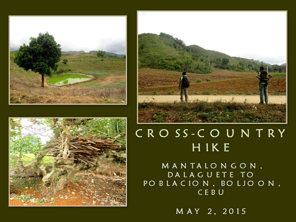
Start of first day hike. Leave Mantalongon Vegetable Market at 11:00 for Alcoy by an alternately paved and unpaved road known as the “Vegetable Highway”. Pace: Moderate. Weather: Warm and sunny.
-
Starts communicating with Base Support of our progress by radio, through a frequency provided by the Argao civic radio group, and by mobile phone. Exploration Team use EAGLE ONE as its callsign while Base Support use EAGLE BASE. Radio equipment in use is a Cignus V85 UHF/VHF Portable Radio Transceiver but radio contact weak as well as by phone.
-
Pass by villages of Langkas at 11:40 and Nalhub at 12:20 and stop at the village of Catolohan at 13:05 to to rest, rehydrate and eat bread from a small store.
-
Resume hike at 13:25 and proceed to somewhere in Alcoy. Weather: Partly cloudy.
-
Cross boundary into Nug-as, Alcoy at 14:00 and pass by the community of Bulalacao.
-
Arrive at the village center of Nug-as at 15:00. Make courtesy call to head of village and ask permission to spend night at their multi-purpose building. Prepare coffee then supper. Food are carbonara, asparagus soup and milled corn. Dinner at 18:00. Weather: Cool. Taps at 20:30.
-
ESTIMATED KILOMETERS WALKED: 12.9
DAY
2 – May 2, 2015

-
Wake-up alarm rang at 04:45. Prepare coffee then breakfast. Food prepared are fried chorizo Bilbao, scrambled eggs, asparagus soup and milled corn. Breakfast at 08:00.
-
Start of second day hike. Leave Nug-as at 09:00 for somewhere in Boljoon. Pace: Slow to moderate. Weather: Partly cloudy.
-
Stop by community of Liptong at 09:10 to drink fresh coconut wine offered for sale.
-
Resume hike at 09:20. Pace: Moderate to fast. Weather: Partly cloudy.
-
Cross boundary into Nangka, Boljoon at 10:30. Radio transmission unsatisfactory.
-
Pass by village of San Antonio at 11:15.
-
Stop by small store at the community of Calot at 11:50 to rest, rehydrate and eat bread.
-
Resume hike at 12:10. Pace: Moderate to fast. Weather: Warm.
-
Pass by villages of Upper Beceril at 12:50 and Lunop at 14:00.
-
Stop by a small store in Lower Beceril at 14:20 to rest and rehydrate.
-
Resume hike at 14:50 and arrive at the village center of Lower Beceril at 15:00 to pose before camera.
-
Resume hike at 15:05 for Poblacion. Pace: Slow to moderate. Weather: Partly cloudy.
-
Arrive at Poblacion at 16:50. Take a rest, rehydrate and eat an early dinner at a local restaurant.
-
Leave Boljoon for Cebu City at 18:00 by bus.
-
Arrive Cebu South Bus Terminal at 21:30.
-
ESTIMATED KILOMETERS WALKED: 20.48


This
present Exploration Team had prepared so well in terms of physical
conditioning that we shaved off a day of its original itinerary by
our pace alone. Another factor which caused us to make this a 2-day
affair instead of three is the presence of the “Vegetable Highway”.
The existence of this little-known vein of progress actually is
unknown even to some people living on the places we passed by. For
most of those who lived along it, it is a blessing.
The
Team officially have logged 33.57 kilometers of walking from Point A
to Point B, basing upon the auto computation of Wikiloc, a web-based
application which can either be manipulated by uploading GPS
waypoints or by manual tracing of the route by a mouse but, I
believed, we had logged more than what we were supposed to since the
absence of a reliable transport system in the hinterlands of Boljoon
forced us to walk down to the national highway located along the
shore.
We
each carried an average of 13+ kilos although we are observing light
backpacking. Food, survival gears and our sleeping equipment had
used up much of our cargo space. It is good that water could be had
along the route even under a mild El Niño phenomenon. The places
where we pass by are still abundant of water so there is no need to
carry more than two liters of water. Along the route are natural
springs which pour out cool potable water for man and creature alike.
On
the other hand, folks see our presence on most of the places we
passed, except at Mantalongon, Dalaguete, as unusual. They have not
seen hikers or outdoorsmen or urbanites with backpacks before and
they viewed us with suspicion until you break the ice by giving them
a smile and a greeting. Ultimately a conversation begins, explaining
your purpose, would make them see a bit but they cannot comprehend of
why we walk when there are vacant seats on a few motorcycles passing
by.
The
completion of Segment V is but one step closer to my objective. The
next routes would not be as easy as the finished segments nor would
it ensure favorable conditions. Definitely, the next segments will
not be a walk in the park and would demand navigation savvy from the
Exploration Team, which that responsibility rests squarely on me.
The CEBU HIGHLANDS TRAIL PROJECT from hereon goes on a high swing of
difficulty but the team accepts that challenge by adapting to what it
demands.
I
have learned so much from the different segment hikes with different
teams. This present team is so flexible and very much prepared for
the physical challenges at hand that it had given me a great
assurance that we can deliver the CEBU HIGHLANDS TRAIL PROJECT true
to its schedule. Me and my team had explored and achieved fifty
percent of the Project and I am quite elated about this. The next 50
percent would be different.
Document
done in LibreOffice 3.3 Writer


No comments:
Post a Comment