Showing posts with label Carmen. Show all posts

Tuesday, March 1, 2022

2022-009 | ADRENALINE ADVENTURE HIKE: SEGMENT VI-A

THIS PASSION BY TEAM Adrenaline Romance of walking the entire length of Cebu, in sub-segments, following in the wake of my epic Thruhike, which I did in 29 days of January and February 2017, have set them afire. They had crossed over the halfway mark of the Cebu Highlands Trail by finishing Segment V last May 24-25, 2019 and accumulated a thought-provoking 230.08 kilometers.

That is already a bragging right in itself that is very difficult to equal by even accomplished hikers, much more so, by their fellow bloggers. Gian Carlo and Sheila Mei, to include their friend Apol, are in a different level right now and I could feel the electricity running in their veins. They have adapted very well to the rigors of the CHT and developed that certain toughness of the mind that I had so recognized during my explorations of the routes.    

I was awakened by Gian Carlo calling me on an early morning of June 29, 2019. He, Sheila Mei and Apol were already in the Cebu North Bus Terminal. It was a shock for me since I always come first and, there, my client took the place of my alarm which I set at 04:00. Daylight already carved the dawn sky! How could that be? I take pride of always being the first to arrive. This time I was very sloppy. 

Anyway, I arrived blushing at 05:35 to the trio and offered my profound excuses. Without waiting for them to decide what would be next, I went straight to a waiting bus that would take us to Carmen. We arrived there at 07:30 and found a small eatery in the public market to take breakfast. We also bought extra food for our lunch which our itinerary says 12:00 at Agsuwao, Catmon. 

We hired motorcycles to bring us up to Caurasan, Carmen, which travel took more than an hour and, instantly, I set about my usual courtesy calls. The village officials expected our coming and it took just a few minutes. Then I proceed to the military detachment nearby and jotted the names of Sheila, Gian Carlo, Apol and mine. The military wished us well and would be monitoring our progress.

We left Caurasan at 09:20, by way of an unpaved road which were lined with flowering indigenous trees of all shapes and sizes. The rugged road becomes half-concrete prevalent on most found on most mountain villages of Cebu. It is just a set of narrow concrete ribbons that could accommodate one set of four wheels one way or a couple of motorcycles each going the other way. 

I walked point retrieving information from memory. The entirety of the CHT was never created with the efficiency of a radionavigation system, which could have produced waypoints, but by the quirks of traditional navigation. It was these invisible routes that my memory tracked feverishly, sometimes placing a stress on my brain, leaving me mentally exhausted at times. 

When I walked, I watched out for the familiar. If I had some doubts, then I would consult the general directions of my compass. Since we were walking north, then north shall be the judge, come what may. My compass, an analog Suuntu A30 – now paired by a digital Casio Protrek sportswatch which I just used recently – had never let me down. 

Sometimes, I would rely with common sense where terrain is concerned. I would never choose a path that goes down, to my false security and comfort. On this moment, you would be tempted to the drift of just going down and, by that time, too much ground had been covered to offset an error. I would opt for higher ground instead and abandon it when the terrain rolled in my favor. 

I saw a trail that branched out of this road and I followed it uphill. At first I was in doubt but when it passes by a community, I began to like it since it looked familiar. I began to like it more when the trail went around the back of Mount Kapayas, whose peak is but a short detour for us if we choose to visit it. I was now in my groove and sniffed the path like a bloodhound.

This trail passed by swidden farms among forests and over beautiful meadows with coconut trees that afford limited views of a remote valley which places I would not want to be lost in. As I mentioned earlier, the drift of travel would somehow lull you into complacency until such time that you discover you are way off your general direction by several kilometers that rectifying it would need a lot of effort and energy. 

Both Segment IV and VI, thirty-five and twenty years ago, was a mass base of a political organization that was engaged in an armed struggle against the military and the overthrow of the government. Because of its remoteness, dotted with thick forests and so many hiding places, these places created a reputation of its own. It became “no man’s land” to the detriment of the residents. 

While I recognized its latent risks, I came with good intentions. These beautiful places cannot just live forever in their past. My introduction of adventure tourism through the CHT, carefully whetted to only a few hikers as possible, is meant to open up opportunities for these communities which difficulties caused by hostilities and distrust have left them with little or no options. 

Since we had been walking for an hour, I picked a spot for rest, known by the locals as Lantawan, where there is an abandoned shelter littered by broken shells of cooked egg. It offered an unobstructed view of a valley and the hills across which belonged to the municipality of Tuburan. We stayed here for fifteen minutes and just enjoyed the landscape. 

We pursued the path once more with vigor, the trail now hugging the steep bulwarks of Mt. Kapayas. For once, it crossed over a steep farm and went down from a ridge grown with mahogany trees. Before me are two paths whose left fork I took during the seventeenth day of my thruhike in February 2017 which could have led me farther away from a path I fixed in my memory until a guardian angel led me to the right trail.

This time, I fixed it permanently. I took the right. The trail still hugged the steep mountain but, no sooner, I espied a concrete path up ahead complete with steel railings. Concrete pavements meant that motorcycles could now penetrate these once remote parts and that is good even when outdoor purists disdained the sight of it. It does not matter to me since it is made for walking just the same. 

I was happy at this path concreting project. Imagine the many years the residents have suffered from neglect of the government and the difficulties brought on by a foreign ideology upon their communities? The sight of this path, from the side of an adventure guide who relied on his memory for navigation, is heavenly! Even if it goes up for around 400 meters!   

We arrived on a small plateau where there is a small community. I followed the trail until we arrived at the house where I last slept in during my epic thruhike. It belonged to the former village chief of Bongyas, Catmon, Mr. Soping Branzuela. I gave him a certificate and left a loaf of bread as my appreciation for his kindness and hospitality. Bread is something of a luxury in these places. 

Since it is already 11:15, we decided to enjoy fifteen minute rest. Once done, we followed a trail down to the village center. I was expecting millet grown on their farms but I was in the wrong season. Only here and in a few adjoining villages where millet is grown. What was grown instead were corn. We arrived at the village center at 12:00 and decided to spend noonbreak here with cold soda drinks. 

At exactly 13:15, we resumed our foot journey. There is another road with a set of two narrow concrete pavements. It goes and it wind among farms, grassy meadows and more beautiful landscapes. While it was warm at that hour, breeze were plentiful and helped to our cause. There was not much traffic on the road except for a few motorcycles. 

At a spot where there is a beautiful small valley, I point to Team Adrenaline Romance the peak of Mt. Kapayas and its neighbor, Torre Peak, from a far distance. They were amazed at the progress we made for just half a day. Sooner, or tomorrow, this mountain would just be a speck just like the last time we saw it from Balamban.

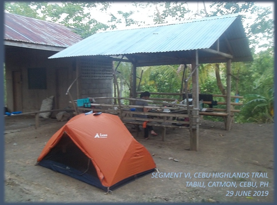
We followed this half-paved road in the village of Agsuwao until it became unpaved, then full concrete for a time and then asphalt that is in need of new topping. A big concrete tablet showed that we are now in the village of Tabili, Catmon, but it would still be a long way to our campsite. At 16:00, we arrived at the home of the late village head, Mr. Danny Demana. His father-in-law replaced him and we were expected. 

I slept here twice: During the route exploration of Segment VI in February 2016, the time I befriended Mr. Demana, and Day 18 of my thruhike. We occupied the space at the back where there was a nursery, a shed and an outhouse. Both Apol and I claimed the shed with its four posts for our hammocks while Sheila Mei and Gian Carlo pitched their tent on open ground. 

Team Adrenaline Romance surprised me with a new aluminum pot. They were amused at the pot I brought last time in Bangkito, Tuburan during Segment IV. It had a hole which made the cooking of rice a lengthy task. This time, rice should be cooked effortlessly; which it did with my Trangia alcohol burner; causing thin streaks of soot to mark its bottom. 

During this time, we enjoyed tea served in small a ceramic kettle and cups which I carried. After supper, we hit the deck at 19:30. It rained hard that night. The roof above me had a leak and one line of drop fell on me. I had to shift position so water would not hit me dead center. I refused to let the rain steal away my sleep and sleep I had after a few wet moments of discomfort.     

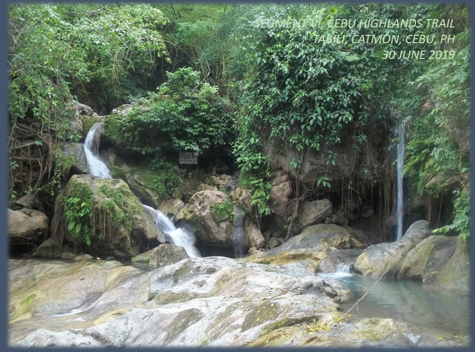
We woke up early at 05:30 of September 30, 2019 and prepared ourselves an attire for swimming. We visited the Tinubdan Waterfalls of Tabili, Catmon guided by the teenaged son of the late Mr. Demana. We hopped on motorcycles for a short trip to the trailhead and walked a short path to the bathing area. This has gained popularity since it was featured in social media by vloggers. 

After an hour enjoying the coolness of an early morning bath in Tinubdan Waterfalls, we returned to our campsite and prepared breakfast. After another round of tea in style, we broke camp. By 08:00, we gave thanks to our host and proceed to a stream that separates Catmon from Sogod. The stream is called Bawo Creek. The day is cloudy but humid owing to last night’s rain. 

After a half hour of asphalt road, we took an unpaved road and, up to a certain point, we took a trail that led us to the stream. It is a beautiful countryside with orchards dotting the landscape. The water was not high and we crossed it without having to remove shoes and socks. There were dry parts necessitating just a little effort to leap over. 

I followed a path through head-high cornstalks until such time we were in open places. I looked back from where we came from and it was a beautiful sight. Farther away, Mt. Kapayas reduced in size to bigger than a speck and Team Adrenaline Romance could still not believe that they placed so much distance from it in a day. The trail has to climb over a ridge that now belonged to Sogod. 

Huffing and puffing, we made it to the ridge. It was as if we climbed a mountain but this was no mountain. It was a plateau of small Chocolate Hills-like mounds, which were farmed by locals in delicate terraces. We were in the village of Cabalawan, Sogod. Further ahead is the village center and the road. We followed this dirt road and turned left on another dirt road at the first corner. 

The road went straight to a large hill planted with mangoes but bent to the left and then to the right until we arrived at a bridge. Beyond this bridge was a trail that traversed over farms and orchards and communities until we arrived at an unnamed creek which I believed to be that of Putat River which spews out its contents to the TaƱon Strait.

We crossed the stream without too much effort and crossed another tributary and we followed another trail that led us to an asphalt pavement. Finding a store, we decided to stop for noonbreak since it was already 11:15. The owner welcomed us and we were allowed to cook rice, boil water for coffee, sit in the shade and use the bathroom.

We left at 12:30 after paying for what we consumed and our profound thanks for the hospitality. The road was abandoned at this hour, the nearby Mangadlaw Elementary School is devoid of children and teachers since it was a Sunday. The road was lined by several communities and solitary houses. By 13:30, we took a courtesy call on the village of Cabangahan, Sogod, scribbling our names on their visitor’s log. 

We resumed our walk on a beautiful stretch of road which has limestone forests on both sides and tell-tale signs of karst cave formations. This was an enjoyable walk because, somewhere up ahead, lay the village of Bagakay, Sogod and their well-kept secret, the Dau Cave, named after a large dau tree (English: Pacific walnut) growing near its entrance. 

We arrived there at 14:15 and made a courtesy call. The accommodating village official offered to guide us to Dau Cave and they have taken considerable effort to clear the vegetation at its approach. After the brief excursion, I retrieved a certificate and bestowed it to the village of Bagakay in appreciation for their assistance in completing the CHT and the success of the Thruhike. 

We bade goodbye at 15:00 and proceed to walk the last kilometers of our journey. Our destination is the village of Mohon, Sogod. On that place is a highway that traversed northern Cebu from Borbon to Tabuelan. We need to be there before dusk and hopefully catch a bus to Mandaue City.

Everyone were suffering from fatigue; walking for hours even though we have enough rest; and completely hydrated. The feet soles were complaining and during this stretch we rest when we could. Although the day’s warmth was decreasing at that hour, aided by shades of trees and hills, we were sweating very much. At 16:30, exactly on the itinerary, we arrived at the road corner. 

This was just the first half of Segment VI and Team Adrenaline Romance chalked up an additional 32.3 kilometers on their mileage, and upped their total to 262.11 kilometers. There was no rush and we made it exactly at what was stated in our itinerary, except on the first day where we did not make it to Agsuwao, Catmon for our noonbreak. This was an exception for I was late at the meetup area.    

Please stay tuned for more adventures of Team Adrenaline Romance in the next month as they try to complete Segment VI by trailing this blogger to Ilihan, Tabogon. How many kilometers would they add to their current total? Expect you to follow their campaign and read Adrenaline Adventure Hike: Segment VI-B. Make your presence felt by giving a comment. Thank you!

Friday, January 7, 2022

2022-002 | ADRENALINE ADVENTURE HIKE: SEGMENT IV-B

TEAM ADRENALINE ROMANCE HAD walked through the first half of Segment IV and came out stuffed with better appreciation of the Cebu Highlands Trail. The challenges of the fresh sceneries that the “no man’s land” route provided have excited Team Adrenaline Romance so much so that they filed a leave of absence the soonest time possible.


When we breezed past Mount Manunggal on our way to Lawaan, Danao City the last time, they begun to enjoy the landscapes of their backtrail and picked off the familiar landmarks which had given their confidence a shaky ground to stand on. The second part of Segment IV – Segment IV-B – has different difficulties than the first and it offers another different side of Cebu. This is still a “no man’s land”. 

We choose the Cebu North Bus Terminal as our meeting place on October 13, 2018. Gian Carlo and Sheila Mei arrived first. Later, Apol came, and we found an empty bus bound for Danao City. The bus left Mandaue City at 05:30 and arrived at Danao at 06:45 and we found a small eatery to take breakfast. We also bought extra food for our lunch which our itinerary says 12:30 at Mount Mago. 

We left the busy city center at 07:30, each astride in tandem on a motorcycle-for-hire, bound for the village of Lawaan, our last place of engagement two weeks ago. We arrived there at 09:10 when the motorcycle I rode conked out and we waited for another. We hit the trail at 09:15. We were following a paved road that was quite shady and very peaceful. We faced a road junction and followed the one on the left.


The road rose in elevation and we were now exposed to the morning sun. As we walked over a ridge, we saw Mt. Kalabasa of Danao City; Garces Peak of Asturias; Mt. Matun-og, Mt. Mauyog and Mt. Manunggal, all in Balamban; and – surprise! – Mt. Babag, Cebu City. These were the great landmarks that we saw on our northerly quest that created furrows on our foreheads. As we checked our backtrails, these were now just drops of water in a pail. 

Walking on, we passed by a farmer harvesting pomelo from his fruit-laden trees and gave us two which Sheila Mei and Apol devoured without a trace and brought another with us. We walked on and we arrived on the trailhead in the village of Pili, Danao City. There is a trail that goes to Mt. Mago but I have to make a courtesy call first to a military detachment located nearby. 

After my business with the authorities, we pushed north at 10:20, following the trail that go over the ridges of this unnamed mountain range. The path is soft earth blazed by generations of feet while all around us are green meadows. It is rolling terrain without forest cover. On a rise, I read an elevation of 755 meters from my Casio Pro Trek.


We still brought a pair of Versa Quicktalk Go UHF/FRS transceivers which we used for our communications in Segment IV-A. While I took the point, Gian Carlo swept last and Apol and Sheila Mei in between. We used the radio to check each other out when visibility is hampered by rolling terrain or when a branch of a trail placed Gian Carlo in a bind. 

We arrived at the camping grounds of Mt. Mago at 12:40 and quite famished. We spent noonbreak here under the shade of one puny tree, enjoying lunch from food we bought earlier and finishing the one last pomelo for dessert. I noticed a pond. It had always been there the two times I was here. I excused myself and made a brief inspection. 

I found out that it is a seep that overflowed to a very tiny brook. I deduced that it became a small stream, ultimately dividing Carmen from Tuburan, until it became a river that flows out to the Camotes Sea. This unassuming pond could be the headwater of the Panalipan River! We took water from the pond and washed our plates, spoons and forks from twenty meters away dowhill.


We left Mt. Mago when dark clouds appeared with the clap of thunder and followed a trail in a forested area. The ground is dry and plenty of loose soil and pebbles. We came upon a very steep part which was kind of tricky. This path is so enchantingly silent that only locals know and, of course, me. Overnight campers would never go beyond Mt. Mago. We rested after that descent and rehydrated. 

From then on it would be rolling terrain once more, passing by solitary houses and farms and, sometimes, a family of cows blocking the way. The trail goes down to the remote village of Bangkito, Tuburan. We passed by a public school, going into their center where there was a basketball game in progress. Everyone stopped playing and looked at us. 

This was one of the critical areas during the insurgency problem in the ‘80s until the early years of the third millennia and everyone wanted to make sure that we were not armed. When they resumed their game, I released a sigh of relief. Then and there, I did a courtesy call to their village council while Team Adrenaline Romance stayed behind to fill water from a water reservoir.


On the way back, I brought a cold big bottle of Coke. We emptied it fast and we hoped we could produce another one later. We prepared our campsite and then our dinner. When the food was almost cooked, I went back to the community store to buy another cold big bottle of Coke. But it was the last they sold to me earlier. 

We had our dinner and pairing it with warm Coke was not bad after all. That night there was another basketball game and there were many onlookers from the different places. After the game there was a disco. The noise interfered in our quest to snatch that sleep. Motorcycles would park nearby and leave. Nevertheless, it did stop at 03:00 of the next day, October 14. 

We woke up collectively at 05:30 with eyes that hungered for more sleep. We prepared breakfast and, after eating, we broke camp. I went back to the village center to give the village council my appreciation of thanks in the form of a certificate, as I did yesterday with the villages of Pili and Lawaan. This was for their hospitality in accepting us in their localities and aiding me and my team during the exploration phase of the CHT and that epic Thruhike.


We left Bangkito and went east for that deep valley under the shadow of another mountain range found across us: Ngipon-sa-Ilaga. I almost missed a trail were it not for a girl who was observing us. After asking her directions, we followed the trail down the deep valley of Anahawan. It would twist and wind its way among the lower foothills of Mt. Mago. 

Cows and carabaos were tethered along trails and we have to make wide detours. When we reach a stream we rest for a while from the brunt of the morning sun. This was the same stream that I suspected to have originated from that small pond at Mt. Mago and this could be the upper portions of the Panalipan River. Downstream of me are small waterfalls and Team Adrenaline Romance had to change to Project BLUE t-shirts for a photo ops.     

After a generous rest of thirty minutes, we resumed our journey. The trails pass by meadows and farms and a very old oleander-leafed euphorbia (Local name: soro-soro). The biggest I have seen. This marked the start of the ascent to Taguini. The trail is well beaten and easy to follow.


We arrived at Taguini so early at 10:00 but it was empty of people and traders. I expected a market fair. I missed by a day! Anyway, we are two hours early for a noonbreak and we decide to have that at the village of Caurasan, Carmen instead. So we spent rest here and bought locally-baked bread and paired it with cold soda drinks. 

After twenty minutes, we resumed the last few kilometers of Segment IV-B. Team Adrenaline Romance, perhaps, assured that the last half of the CHT was about to end, walked with a confident and springy stride this time. We reached Caurasan at 12:30 and checked in at their village center with our identification cards with a civilian interloper who insisted on voter’s ID! 

After that, I did another courtesy call on a military detachment nearby and then we ate lunch there. We left Caurasan for the town market of Carmen astride motorcycles-for-hire. The ride down to town was a long one and we arrived at 14:00, time good enough to take it easy for our return to Cebu City. Team Adrenaline Romance celebrated their feat with an early dinner in a Japanese restaurant inside SM City.

Team Adrenaline Romance had achieved one-half of the CHT by finishing Segment IV-B, which was 17.68 kilometers in length. With that, they extended their mileage total to 207.73 kilometers which was quite impressive! They had adapted to the rigors of what it was like when walking a long trail like the CHT which is partly wild, very humid, unimaginable difficulty in terrain and somewhat dangerous!  

The lands we passed by in all of Segment IV, to include parts of Segments I, II and III, were indeed very dangerous if we walked it in another time, say 1987 or 1995. That is the reason why adventure tourism and outdoors leisure activities did not grew beyond the known safe havens. Many have tried to open these corridors among Cebu’s mountains but it never prospered. 

The exploration of the CHT and its opening to the public as a guided adventure hiking tour came at a favorable time when such threats and troubles to foot travel have disappeared although residues of it remained which comes in the form of suspicion and distrust. By and by, people will come to terms with their past and embrace change which is harmless, fun and productive.  

Gian Carlo and Sheila Mei wrote about their Segment IV-B experience on the Adrenaline Romance Blog under two installments: 

Cebu Highlands Trail Segment IV-B: Lawaan, Danao to Bangkito, Tuburan.

Cebu Highlands Trail Segment IV-B: Bangkito, Tuburan to Caurasan, Carmen.


Wednesday, December 1, 2021

2021-046 | THE 3RD CAMINO DE SANTIAGO OF CEBU: DAY 4 & 5

A RAINBOW GREETED ME as I enjoyed a cup of coffee on the balcony of the San Pedro Calungsod Parish rectory on the fourth day (June 21, 2019) of this Camino de Santiago from the North. The hills were still swathed in mists as an early rising sun bathed it in golden light. It was a magical feeling, almost surreal. 

Behind me was the imposing height of Mount Manghilao, a great landmark of Masaba, Danao City, as seen from anywhere. Across me, far more distant than these hills swathed in mists, was another landmark: an unnamed peak. That mountain would be my signpost later on my journey to Compostela. 

I arrived here yesterday at the San Pedro Calungsod Parish together with fellow pilgrims Renita Reynes, Erl Durano and Grace Lina. Fr. Junly Cortes, the parish priest, had welcomed us and took care of our comforts and needs. We had taken baths in the early morning and were now seated with Fr. Junly at the breakfast table.

This Camino de Santiago from the North was the last of the three Camino de Santiago established in Cebu, at the behest of the former parish priest of the Archdiocesan Shrine of Santiago de Compostela, Fr. Scipio Deligero. We started from the St. James the Apostle Parish in Sogod four days ago and this exploratory Camino Cebu has brought us here in very good hands. 

We have stamped our credenciales with the parish seals of St. James in Sogod; the San Guillermo de Aquitania in Catmon; the St. Joseph the Worker in Binongkalan, Catmon; the Our Lady of Mount Carmel in Cantumog, Carmen; even that of the St. Benedict Monastery in Corte, Carmen. We have also secured one from Fr. Junly’s parish. 

This was a journey that had turned out well despite it being exploratory in nature. I was commissioned by Fr. Scipio to find and identify the routes but I decided to involve the three ladies instead, who really were all veterans of another but much longer Camino de Santiago from the South which they walked in January 2019.

Fr. Junly, who is an adventure racer, knows the hinterlands of Danao City for this was his training ground. He showed me a path and mentioned all the places that we needed to pass in order to reach the next parish: Our Mother of Perpetual Help in Ibo, Danao City. This time, the Camino Cebu would pass long stretches of trails and unpaved roads. 

We left Fr. Junly and his parish at 07:30, following a low ridge which goes amongst farms and homesteads. The appeal of trails on this fourth day for the Camino de Santiago was a different experience. The soft ground that crunch underneath your shoes was most welcome for any feet but it brought with it a certain caution when you experienced the usual skids.

These part of the Camino Cebu was unexpected and was never thought of in my itinerary. I literally created another itinerary based on this and shall be permanent. We were walking over ridgelines, among meadows, within pocket forests and small communities where residents helped us with our journey. 

We crossed a small stream and went over another trail that led to an unpaved road where there was a chapel which then led to a paved one in the village of Mantija, Danao City. We arrived at 08:30. After fifteen minutes of rest, we resumed our journey. Then it passed by sparsely-populated areas, farms and more pocket forests.

The weather cooperated and we really enjoyed this part. We just walked without so much strain. We were just killing time. I even forgot the mandatory rests of fifteen minutes after each hour of walk. This casual-like walk led us to a steel foot bridge. Below us was the Danao River. Across us was the village of Ibo, Danao City which we came upon at 10:15. 

While I was walking searching for their parish, I mistakenly presumed a local wearing a palm hat and an open-carried bolo as a farmer until he identified himself as Fr. Porferio Mahinay Jr., the parish priest of the Our Mother of Perpetual Help. What humility! I even learned later that he was a licensed civil engineer! 

He welcomed us into his rectory. His parish is kind of busy since their village fiesta was approaching. On the dining table were fruits and vegetables brought by his parishioners as offerings and donations. There were no concrete structures yet for the church. Fr. Jun utilized a chapel as their temporary house of worship. 

Fr. Jun was very much happy to receive us but he has no word of our coming since his locality has no cellular phone signal yet, much less, the internet. It was cool inside and we were served cold juice which helped to our cause. After 30 minutes of rest, it was time to leave again for the Camino de Santiago.

Taking the hint from Fr. Jun, we followed an unpaved road bound for the village of Togonon, Danao City. Midway, the road became paved and the air became warm. This familiar landmark of a mountain that had left me marveling in the past was now in my midst. It has bare karst formations which are used by local rock climbers. 

We stayed under the shade of a small store by a road junction to spend our noonbreak. The lady storekeeper was most happy to serve us instant noodles and, later, just coffee for me. After an hour, after asking directions from her, we took the road on the left which goes up to the higher elevations of this unnamed peak. 

At 13:00, we huffed and puffed on an ascending road but, once we were on a level terrain, the road became unpaved and showed its true character. It was very shady, due to presence of a second-growth forest and there were no houses along the route. Another enchanting road that gave you the creeps. 

This was a rather long stretch and I liked it that way. I could see valleys below and the mountains that shaped this new landscape that I have seen for the first time. Beyond, far away, are familiar trysting grounds. Then the enchantment gave way to a small community and more of it as the gravelly road became concrete again and goes downhill. 

We now crossed into the village of Dapdap, Compostela. In a very spacious community shelter, we found rest at 14:30. I have never been in this part of Compostela. After 15 minutes, we proceed passing by a junction which led to the village center of Dapdap on the right and to another village, Mulao, Compostela, on the left. I took the left.

The road goes downhill, crossed a stream, goes a little up and goes down again and we were in another junction: the right goes to village center of Mulao while on the left to the village of Basak, Compostela. I know this part very well and what to expect. Just like yesterday, we climbed a hill in the morning and another in the afternoon. This time it was at lesser proportions and I know where I was going. 

We finally arrived at our resting place for the night at 16:00. It was not a parish that we were so privileged to rest for three nights but a humble home that a family had dedicated to welcoming pilgrims of the Camino de Santiago. This was the third time that Frank and Minnie Catampatan hosted me and my pilgrims and I could not find the happiest second home but here.

Woke up to the crowing of the cocks for this fifth and final day (June 22) of this Camino de Santiago from the North, we were treated to a good breakfast again. We were that pampered, thanks to Santiago de Compostela, who provided, from out of nothing, comfort, kindness, empathy, protection, nutrition, charity and piety. At 08:00, we left our kind hosts and proceed to finish this exploration and pilgrimage today. 

It was getting warm by the time we left Basak although the path was very shady. We were approaching the great highlight of all the three Camino de Santiago: the “Cross of Triumph”. This cross was erected in 2016 on top of a hill and is a hundred feet high, the biggest in the island of Cebu. Upon this cross, pilgrims leave their pebbles carried since Day One of their spiritual journeys. 

We arrived on the great cross in Bagalnga, Compostela at 09:15. I left another pebble. Renita, Erl and Grace did, likewise. Aside from pebbles, which actually represents our old self, we said our personal prayers here as well as prayer petitions from relatives, friends, classmates and neighbors, hoping for small miracles in their lives. These prayer petitions came in verbal requests or written on papers.

The morning was just so perfect. There was no pressure and we just enjoyed the view and prayed the five decades of the holy rosary facing the lowlands and the Camotes Sea. By 10:00, we went down the hill and followed a narrow concrete road down to a much busy road in Guila-guila and sate our thirst with cold soda drinks inside a small store at 10:45. 

After 15 minutes of my standard rest time, we walked again this busy thoroughfare, muddied and hosting puddles of turbid liquid after a hard rain last night. We turned right on a much better road but lacking in shades. It was now very warm and the road rose up but I know where it would take me. This was the last obstacle. 

We arrived at last at the Archdiocesan Shrine of Santiago de Compostela at 11:40. Bells herald our coming and the welcoming committee was most happy of our arrival for we had accomplished our mission: that of establishing and completing the third route of the Camino de Santiago for Cebu. Fr. Scipio Deligero had delivered his promise before ending his stint in this parish come August where another priest would assume his post.

Renita, Erl and Grace had the distinction of the only other pilgrims who walked this Camino de Santiago from the North, as well as that rare feat of walking both this northern passage and that of its much longer route from the south. All three have grasped the full meaning of being a pilgrim and so have found a different avenue of spirituality. However, Renita, most of all, had achieved a most rare deed: that of walking the three different routes of the Camino Cebu.   

On my part, the opportunity to work with the Roman Universal Catholic Church, notably with the Archdiocese of Cebu, and to my close devotion to St. James the Apostle, had transformed me into someone that I have not had dreamed of before. It was a calling and I answered it. I am in a unique situation after I helped establish the two longest routes of the Camino de Santiago here. 

This special relation granted me certain spiritual privileges, or indulgences, if you may, which I could never achieve with my sinful ways, past and present. This was more than monetary compensation, titles and prestige. My church is kind enough to give me certain earthly privileges as well to work as an independent guide. While it may have a certain air of prestige but, do not be misled, it is a very demanding work. 

Cebu now has three Camino de Santiago routes. The first one was the one from the south, starting from Badian, 175+ kilometers long and walked in ten days. It was established in 2017 and is now the premier route. The second is the one walked around Compostela and Liloan, which is 28+ kilometers and walked in two days. This was first walked in 2018 and is the most popular. Then we had the one from the north, walked in five days at 65+ kilometers.

iBuen Camino!

Sunday, November 7, 2021

2021-043 | THE 3RD CAMINO DE SANTIAGO OF CEBU: DAY 3

WE PILGRIMS ARRIVED AT the Our Lady of Mount Carmel Parish, Cantumog, Carmen yesterday afternoon, June 19, 2019; which was the second day of the inaugural pilgrimage of this third Camino de Santiago of Cebu. This route started from the St. James the Greater Parish, Poblacion, Sogod on the first day, June 18th. 

While this may be an exploratory walk, which the then parish priest of the Archdiocesan Shrine of Santiago de Compostela, Fr. Scipio Deligero, have commissioned me to be realized before he would end his term, it is also an educational campaign. My team of pilgrims played their role very well as the unofficial representatives of St. James or Santiago de Compostela. 

The pilgrims were Renita Reynes of Compostela; and journalists Erl Durano and Grace Lina. They were the only ones available when I knocked on former pilgrims for company. All were veterans of the Camino de Santiago of January 27-February 5, 2019, which arrival coincided with the 2nd National Congress of St. James the Apostle Parishes and Devotees hosted by Compostela. 

We were very blessed to have attended two Eucharistic Celebrations. The first was on the very first day, before we started from Sogod; and the second was here which was concelebrated by fourteen priests led by the parish priest, Fr. Fiel Suico, yesterday evening. This early morning of this third day, June 20, we would be blessed again to attend another Holy Mass. 

Fr. Fiel invited us for breakfast first with his guests, all of them his classmates in their seminary days. They were having a reunion and Fr. Fiel was the host. To everyone on the table, we explained the Camino de Santiago. They have heard of that but they never have an inkling that it was already established here since 2017. In fact, they were witnessing an actual Camino de Santiago with our presence. 

After breakfast, we proceed to the Our Lady of Mt. Carmel Parish for another concelebrated Mass at 06:30 led by Fr. Fiel and seven other priests. It is good to be in the middle of all these. The adrenaline rush of an unexpected journey tempered by the familiar rites of my faith. The good thing is you get to know those who worked in the parish and listen to their stories. 

At 07:15, we bade goodbye to Fr. Fiel and his peers and the people who made our stay worthwhile. We were encamped yesterday on the fringes of the parish grounds where there where trees but, even so, we were invited to enjoy coffee, biscuits and fruits at the rectory when their parish priest was out. I have a souvenir from them – an avocado seed – which I intend to bury on the last day when we are at the Cross of Triumph.

I already know where Fr. Fiel would be next assigned and I hope we would meet again there in his new parish on another Camino Cebu. So was another classmate of his. Hefting my heavy High Sierra Titan 50 with much greater confidence, I set on leading this last of the Camino de Santiago from the north on its third day. We are going down a road which joined a wider but busier road.

We arrived at a part of this road where one goes to Caurasan and the other to Corte, where all the monasteries are. We chose the latter because it is in our itinerary. Surprisingly, despite its remoteness, the pavements are concrete. The width of the road is wide enough for two trucks. It goes steep and, along the way, we find mountain resorts that we thought never existed here. But there they were. 

At its steepest part, another road branched on the right. A concrete arch says we are at Saint Benedict’s Monastery. This one I have heard many times and I was tempted to explore the place. Monasteries are places of worship where isolation plays a big part in the residents’ spiritual growth and I might be visiting at the wrong hours?

The neat courtyards beckoned me the more to intrude into its solitude. There is a sense of holiness in the place, especially at the part where there is a long flight of stairs that led to a huge image of the Santo NiƱo de Cebu amongst the backdrop of verdant mountains. When I was about to turn back for the Camino de Santiago, a man came out from another flight of stairs and asked us of our purpose here.

We told him that we were just carried away by our curiosity. He identified himself as a priest but he has a different accent. He was from India and he was the administrator and spiritual director. He invited us instead to the monastery building where he explained the origin of their order and how did they started here upon learning that we were in a pilgrimage. 

Inside were beautiful paintings, statues and glass mosaics that you only saw in TV documentaries and encyclopedias and, later, in the Internet. It is as if we were in Italy or some other European city. One painting caught my interest. It was that of Pope John Paul II meeting Mother Teresa. Two of the holiest people in contemporary times who are now saints. 

In a corner was a glass showcase where the monastery sold items and souvenirs for their upkeep. All nice things! As I was choosing one from among the many, my attention was called upon by the arrival of a team of policemen from the Carmen Police Station. I have been expecting their presence since I made a courtesy call a week ago on their mother unit – the Cebu Police Provincial Office. 

After a photo documentation with the policemen, we decided to stay longer here by praying the five decades of the rosary inside the Our Lady of Manaoag Chapel. When we left the monastery, it was already 10:25, yet we managed to have our credenciales unexpectedly stamped with their seal. We have stayed more than an hour and we have far to go. 

Good thing, even at this hour, shades from an exotic mahogany forest occupied both sides of the road. We passed another Franciscan monastery but it is best that we do not disturb their solitude. We hiked on up this steep road until we were now at another corner where a sign says Cebu Safari and Adventure Park. 

Nearer to that is a small restaurant constructed out of two steel cargo containers. It is 11:10 and it is near noontime. Why not spend noonbreak here? For a good reason, I forego of cooking lunch when on the long trails. The lady pilgrims brought cereal bars and chocolates for nutrition to save on time and to enjoy a longer siesta.

By 12:00, we resumed our walk and finally reached level ground. No more uphills this time and it is lushly forested with a mix of exotic and indigenous trees. I have never been here and I believed we are now on the highest ridges of this mountain range in Carmen. The road feels so enchanting under the noontime day. This would be eerily dark at night. 

A concrete signpost says that we are in the village of Lanipga. Five minutes later, we were now on a road where there is another branch. I consulted my compass and the needle pointed favorably on the unpaved branch. This road goes downhill this time, passing by a well, then on to hillside farms.

We left the safety of the shady trees into paths lined with coconut trees. The warmth of the day became real once more. When a breeze slapped through you, what a relief it would bring, even though how brief. Communities began to take shape here. We stopped by a shed to rest away from the sun and we learned that we were now in Canhumayan, Danao City. 

I was now filling in the blanks that my itinerary could not identify right after leaving St. Benedict’s Monastery. There were so many surprises brought about on this third day of the Camino of the North. The familiar rush of adrenaline with the discovery of new places was revving up and playing on my juices. The weight on my back became nonexistent as I put forward one foot over the other. 

I have been navigating, most of the time, on dead reckoning and my directional sense have never failed me except of a few occasions where a blunder would cost me more time and energy and doubled the distance. Over the horizon is Mount Manghilao, which became my landmark. Below that hill is our theoretical destination.

Crossing a small stream, we are on another pebbly road which connect to a paved one which seemed to be busy. We arrived at a very busy corner next to a public school and enjoyed iced candy to cool ourselves. Crossing a small bridge, we were now following another steep road which seemed to have no end.

We were now tired. We just hurdled a mountain range in the morning. Now, in the middle of the afternoon, where our energy reserves were on the wane, another mountain range. The road bent and snaked its way up the hills until we saw the most welcome sign: San Pedro Calungsod Parish. It is 16:05 and we are in Masaba, Danao City. 

We were expected and Fr. Junly Cortes welcomed us into his parish. The parish is under construction but the rectory is very neat and modern, being new. I was assigned a room while the ladies have their own. Cold juice drinks were prepared and it is most appreciated by a thirst-tortured throat. Then I saw a small statue of St. James on a small altar near the balcony. We were almost home!