
TROPICAL
STORM LUIS is hitting landfall today, September 14, 2014, in Luzon,
and it had brought great volumes of rain for the past days here in
Cebu. It had rained at dawn and I do not mind if it will also rain
on my scheduled activity this early morning. I am at Tisa eating
bread with coffee and I wait for Bogs Belga, Dominik Sepe and Mark
Lepon to arrive. All came early. Very good!
When
we had secured ingredients for our noontime meal, we left Katipunan
Street and proceed to Riva Ridge Subdivision where there is a road
that led to the trailhead of Freedom Trail. Freedom Trail is the
route which I had pioneered in 2009 that traverse Tisa Hills, Banawa
Hills, some fringes of the Buhisan Watershed Area, Baksan, Arcos
Hills, Sapangdaku with terminus at Mount Babag. It was used during
Freedom Climb 2009 and again in FC 2010.

I
had last used this route in April 2011 (BUSHCRAFT BUHISAN 7:
Training the Pulag-bound) during an endurance training for
members of Tribu Dumagsa Mountaineers who were preparing for a climb
to Mount Pulag. In that hike, we passed by Kilat Spring and
Starbucks Hill, before finishing it at Napo. Today, I will follow
that route and, hopefully, scale again the fabled Starbucks Hill.
We
reach the trailhead. The ground is wet, dews adhered to the blades
of strikingly-green green grasses. Overhead are rainclouds while a
strong breeze blew in from the southwest. Rain is ominous but I do
not mind. In fact, I welcome it. I reach a sentry post and I
retrieve my Chipaway Cutlery Bowie knife from my Silangan
Predator Z bag so I could open carry it below my waist.
When
you are with a Camp Red Bushcraft and Survival Guild activity you can
relish that freedom of carrying a knife openly. It is a privilege
that might had been denied to you when you are with another set of
people but, here in Camp Red, we ensure you that you will enjoy that
right. Along the way you will learn what is the wisdom behind the
carrying of knives. For that matter, outdoorsmen of tougher
character begins to seek our company.
When
we had crossed a cleavage, I begin a practical lecture about tracking
while walking along the trail. Since we are on hard ground, tracks
are invisible and impossible to read but by touching the surfaces of
stones, you will know if people pass by here recently or not. There
are two different techniques for that: one for the dry season and
another one for a rainy day.

I
intentionally brought them to a different trail and, forced to find
the correct trail, we took an animal trail, hoping we could find a
perfect footprint, which we did, on a farm. Seeing a deep imprint, I
touched the ground if it is soft or hard. When I found that it is
neither, I explained to them about the gender of the foot that made
it; the rough estimate of time that the footprint was made;
approximate build and height of the owner; and the possibility that
the owner is carrying a heavy load or not.
We
cross an open field until we come upon Freedom Trail again.
Rainclouds are a blessing when taking this trail since it is really
warm and sunny here. Then I thought of the many who have planned an
activity for today at any place outdoors but decided not to push
through because of Typhoon Luis, of this inclement weather, of muddy
trails and of getting wet. I sneered at that attitude. Most of
these people loved to use the word “adventure”.
I
reach the mango tree on a high saddle and I shift to Kilat Trail. I
will again be reunited with the natural spring of Kilat. I found
this place while hiking and exploring alone in September 2010.
Although locals visit here often to source their water needs, it was
unknown to conventional hikers until I brought a few here but these
returned and brought more of their kind. The natural spring gave
them an option to rehydrate and replenish.

Water
poured out of the ground when lightning struck the place many years
ago. A burnt stump of an antipolo tree (sp. Artocarpus
blancoi L.) stands as a mute reminder while a fig tree growing over
the hole nurture its sweetness. Today, I met a man while going down
there. We exchanged conversations and I was alarmed when he told me
that people from the nearby abomination called Monterazzas de Cebu,
conducted a survey there.
That
could only mean that they aimed to claim the rest of the Banawa Hills
and deny people access to Kilat Spring or, for that matter, claim
Kilat Spring for themselves. Behind their palaces and mansions is a
watershed area that had provided drinking water to the poorest
quarters of Metro Cebu. The government should know that developments
adjacent to watersheds are regulated, even prohibited, depending upon
its vulnerability. I believed I smelled dead rats somewhere in the
offices of the DENR and the Cebu City Government.
I
reach Kilat Spring and I see people washing their clothes while the
children help their parents with the laundry. I gave away my sweet
buns to the children while we stayed for a while to boil water for
coffee. Dom and I forage dry firewood and natural tinder, which are
rare because everything is wet. It does not matter but we have to
try and we did make a small fire just enough to boil water good for
four people.
Satisfied
with our coffee and after filling up our extra bottles, we left the
place going by way to the Portal. The trail is excellent and it is
thick with vegetation. Beside the trail is a path hacked for a tree
planting project. Each stick marks where a young tree is planted. I
reach a point on the trail that I came to get lost often. Today I
know where I am going. The sticks told me so. Easy!
When
I got past that, I pass by the section where upland marsh palms
(saksak) grew abundantly. The palms are flowering and in
bloom and nobody had harnessed their saps, which would usually pour
out from a flower petiole when cut, that can be used as a strong
drink (tapuy) or into vinegar. It only shows that some
essential primitive-living skills are not anymore available to the
present generation. Why not do the harvesting myself? Hmm...why
not?

When
we reach the Portal, we rest. It is 10:30. I am eyeing Lensa Trail
today and it would lead me to Starbucks Hill. I hope. Last time,
after I scaled the small peak (BUSHCRAFT BUHISAN 12: Circles),
I got lost when I followed a wrong ridge for an exit route and dumped
me and the rest instead on a small but suffocatingly-hot valley.
Ultimately, I was able to extricate my companions from that place by
following a set of scant tracks on a trail-less terrain. That was in
April 2012.
Abundance
of rain for several months have thickened the vegetation and the
trail looks gloomy. I do not fear snakes for snakes are lazy
creatures themselves during a cold rainy day. My worry is the soft
ground and the harmful plants that grow along the route. The ground
is almost covered by thick bushes and long grasses now and I have to
pay attention closely of deceiving paths that led you to nowhere but
disappointments.
I
do not want to waste time going back and forth borne out of
overconfidence and reading the wrong path. I need to be sure where I
am going. Somewhere along the path is a small palm that marked a
fork of a trail. The left branch would lead to Banica Creek while
the other would follow the contour of the terrain. I would make it
sure that I will not miss the plant. I follow the right route going
into a very long bend until I see a mango tree.
Mango
trees are quite rare in Buhisan, especially at its wildest parts. We
may have to stay here for a while since it is already 11:00, just
about right to prepare a meal. Underneath is a rare clearing and
almost flat. It had been visited recently by people. I retrieve the
pork, my AJF Folding Trivet and my sooth-blackened pots from
my bag. Dominik and I forage again dry firewood. We got only a few
dry ones.
Dominik
begins to slice the pork with his Hemvarnet knife. Bogs and
Mark helped him by slicing the other ingredients with their Mora
and Seseblades, respectively.
I explore the place and some bushes had recently been cut. I
secured three long sticks and a vine and brought it back to the
resting place. Dom had already started a fire. A pot is placed over
the fire iron. It will be used to cook braised pork.
I
prop a tripod over it where the bigger pot containing rice would be
hanged beside the first. Only one fire will cook our food inside the
two pots simultaneously since we do not have plenty of dry firewood.
One pot is placed directly above the flame while the heat carried by
the breeze will do the cooking of the second pot that is hanged.
Bushcraft is like that. Full of improvisations. Quick to adapt to
any situation.
We
had our lunch at 12:30. Bogs had added a dish of sliced raw cucumber
in vinegar to the fray. It is a simple meal. The braised pork is
excellently prepared. I believed we had taken many refills that the
bottoms of the pots are scraped clean. We have extra water to clean
the pots and to boil some for tea. We revived the fire and burn
small scraps of garbage and, when finished with that, we thoroughly
put it out.
After
repacking our things, we resume at 13:20. The trail really is
difficult to follow since the time we left the Portal hours ago. It
is now covered with so much vegetation. I arrive at another trail
fork. One goes down while the other goes up. I remembered I had
taken an ascending trail and so I took this trail. A small snake
instantly move away upon noticing my presence. I advised everyone to
be a alert.
It
is a long ascent and I could not believe, after that, I come upon a
house with barking dogs. It is not supposed be there or I may have
missed a trail again. I see clusters of houses below us and I take a
trail instead leading to a nearby ridge. That ridge is good and well
covered. One could camp here without being noticed and would have
been a perfect place were it not for the nearness of houses. The
trail ended abruptly. I look for other paths but found none so I go
back to the lone house and then down to the community.
It
is a very secluded community and it is the first time I have visited
this place. I asked a man for the name of this place and he said it
belonged to Baksan. He pointed me to a route going to the road but I
have other things in mind. I need to visit again Starbucks Hill and
I asked instead another route to the Buhisan, apart from the route
that we had just came from. He pointed a path. I gave thanks and we
are still in the game.
When
I arrive at the branch of a trail, I followed it and it goes on a
long stretch of soft ground. I remembered this route now. It pass
by a huge rosewood tree, standing straight to the sky, and everyone
are amazed when all see it. The soft ground gave us difficult
footing. We rely on our hands, grabbing at anything to keep our
balance and to keep us from slipping down. We pass by a patch of
broken rocks. Loosening one might trigger the whole hillside to
slide down so we chose where we step.
It
is silent save for the singing of the cicadas. It never rained but
drops of moisture from leaves fall from time to time. Our clothes
are wet because of that. The path is wet. The ground gave in to
weight. It is a very tiring walk. Mark found a rusting empty shell
of a Garand rifle and kept it as a souvenir. We persevered until we
reach a ridge. The ridge goes down to a saddle. I stood looking at
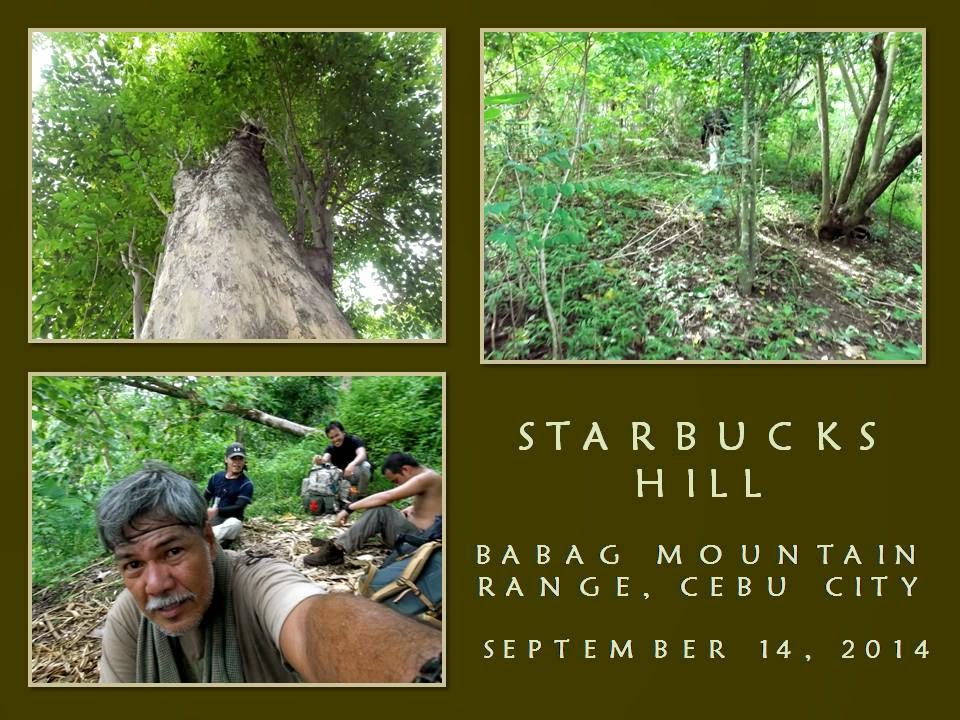
the familiar back of another ridge – Starbucks Hill.

The
rest are exhausted and all sat on dead poles like I did. Infront of
them is the fabled peak! It is still 14:30. Is this really
Starbucks Hill? Dominik, who was in that hike of April 2011
(BUSHCRAFT BUHISAN 7: Training the Pulag-bound), remembered.
I do not know, but there is something amiss. I looked around the
saddle, at the tamarind trees and at the peak. There is something
that I have noticed as odd but I cannot recall what is that.
Anyway,
I urge the rest to move because, after that, it would all be ridges
that end near a road. I had never expected that there is now a
well-used trail leading to the peak nor I had expected to move easily
upward. This is something new on Starbucks Hill. I reach the top in
less time than I had expected it to be. The breeze is always cool
here. It cooled my superheated body and so for the rest.
I
need to find that huge tamarind tree where the “coffee bar” is
located. When I had visited here the first time (BEBUT’S TRAIL
5: Starbucks Point), I was with Ernie Salomon, Boy Toledo and
Glenn Domingo. We brewed coffee here – under that big tamarind
tree – and that is why this place is called Starbucks Hill. It is
a special place. A good place to rest from the noontime sun for
breeze coming in from the sea are plentiful here.
I
am very careful now, intending not to be misled just like the last
time. My mind says “RIGHT” all the time, always keeping to the
rightmost path if ever there are trail forks. I saw none, much more
so the “coffee bar”. Strange. I am now following a descending
trail and re-tracing it back to the ridge is now daunting since I
covered a lot of ground already. I looked for signs. Somebody just
left a bundle of freshly-cut fish-tail palm leaves.
I
see black seeds of a zingiber plant on the ground. It is not
scattered but grouped like a mound. A Malayan palm civet left it
long ago as its dropping but it is now very dry and very light. I
thought I heard a rustling of dry leaves on the ground. Might be the
rest of the guys coming down after me. As I walk down a few meters,
something moved far from my right and it created a lot of ruckus. A
sizable snake is fleeing away in a frenzy.
The
path I took led me to a stream. It is Lensa Creek all right. The
one that supplies water to the catchment basin and then to the dam of
Buhisan. We have walked very far and I cannot explain why I am again
dumped on another exit. I will have to follow the course of the
creek upstream instead, intending to reach Camp Damazo thence to
Lanipao and Napo, but it is still a long way. It is now 15:15 and
too few hours of daylight. Then I saw a shoeprint on a sandbar.
The
shoe is threaded. This is interesting. I called everyone to study
the print and asked of their opinions. Dom says it is a hiking shoe
and it is going upstream. Very well. Let us see if the rest of the
tracks just ahead weave a different tale. A woman may have left this
considering that it is a narrow shoe and small. About size 7. We
found the same tracks but I found one unusual print. The heel dug in
deep. It is made by a rubber boot. It is not made by a hiker but by
a local and it has a dog for its companion.
While
doing all this walking on the streambed, I chose to step on boulders.
When we walk on forested ground, I chose the stones and roots
instead of stepping on the wet path. I deliberately show them my
walking habits even to the extent of going back to a shoeprint I
intentionally left and wiping it away. This is done to leave no
trace of my passing and from being observed by another person. It is
not related to the Leave No Trace, but a skill taught to me by
grandpa when I was a kid. Ages before LNT was born.
The
stream gave in to forest then stream again. Another set of
shoeprints – I mean, bootprints – are discovered by us. It goes
downstream. Why? Because a pebble was dislodged from its hole when
the foot stepped above it and moved an inch downstream. It belonged
to a man. Why? Because it is size 9 and the imprint is deeper than
the first set of tracks we saw. Up ahead, I saw the twin logs and I
am near. We walk on until we reach Creek Bravo.
Mark
and Bogs are now suffering from cramps. Walking on a streambed is
very taxing and would stretch some of your leg muscles because you
will be using a different set of muscle tissues that is different
from those you normally use on a trail. Camp Damazo is on a high
ground and it would be difficult for them. We may have to rest more
often and they would have to rehydrate more often. It is a slow
process going to Camp Damazo and daylight is losing its brightness.
We
reach Camp Damazo. We rest again. It is 16:15. Just a little more
and we will be on Baksan Road. I walked with Bogs while Dominik
accompanied Mark. Our distances lengthened. I reach the road at
17:00 and waited for Dominik and Mark. They came at 17:20. The
trail to Lanipao is now easy as it is all downhill. We use LED
torches when darkness overtook us. We took cold refreshments at
Lanipao at 18:30.
Our
last engagement is Napo. We reach it at 19:00. Motorcycles-for-hire
whisk us one by one to Guadalupe. Lessons were learned during the
hike and these hardy individuals that I am with had came out of that
difficulties smarter and better. For me, it was my last tryst into
Starbucks Hill by way of Lensa Trail. From hereon, it shall be a
“Holy Grail” to any bushman worth his salt who seeks it.
Note:
For a purpose, I never document some of my routes with GPS or given
grid coordinates and, lacking that, it ups the ante for adventure.
Document
done in LibreOffice 3.3 Writer
Some photos courtesy of Mark Lepon


No comments:
Post a Comment